Horsey Windpump and Horsey Mere
![]()
![]() A fine circular walk visiting an early 20th century drainage windmill on the Norfolk Broads with lovely waterside footpaths along Horsey Mere and other waterways. It's a beautiful area with reedbeds, marshes and the option of extending the walk to the nearby Horsey Beach where you can look out for grey seals and explore the dunes. Horsey Dunes, together with the adjoining Winterton Dunes, also contain the largest colonies of dark green fritillary and grayling butterflies in Norfolk.
A fine circular walk visiting an early 20th century drainage windmill on the Norfolk Broads with lovely waterside footpaths along Horsey Mere and other waterways. It's a beautiful area with reedbeds, marshes and the option of extending the walk to the nearby Horsey Beach where you can look out for grey seals and explore the dunes. Horsey Dunes, together with the adjoining Winterton Dunes, also contain the largest colonies of dark green fritillary and grayling butterflies in Norfolk.
The National Trust owns the mill so you can enjoy a climb to the top and enjoy fabulous views over the mere and surrounding broads. The area is also great for wildlife watching with Bitterns and Marsh Harrier to look out for in the air.
Highlights on the walk include Horsey's thatched church with a Saxon round tower and fascinating interior. You will also pass the 18th century Brograve Mill. The mill is now a derelict Grade II listed building and the earliest surviving tower mill in the Broads.
There's lots of good options for extending your walk. You could head just a mile to the west and visit Hickling Broad where you can pick up the Weavers' Way long distance trail. The trail runs around the broad before picking up delightful riverside paths along the River Thurne.
Postcode
NR29 4EE - Please note: Postcode may be approximate for some rural locationsPlease click here for more information
Horsey Windpump and Horsey Mere Ordnance Survey Map  - view and print off detailed OS map
Horsey Windpump and Horsey Mere Open Street Map  - view and print off detailed map
Horsey Windpump and Horsey Mere OS Map  - Mobile GPS OS Map with Location tracking
Horsey Windpump and Horsey Mere Open Street Map  - Mobile GPS Map with Location tracking
Explore the Area with Google Street View 
Pubs/Cafes
For some post exercise rest and refreshment you could head to The Nelson Head in the village. The redbrick traditional country pub includes a cosy open fire and a nice beer garden. Inside there's an interesting interior with a large collection of marshman's implements, local pictures and Nelson memorabilia on display.
There's also good quality locally source food, real ale and a parking area. They are also dog friendly. You can find them at a postcode of NR29 4AD for your sat navs.
Further Information and Other Local Ideas
The Winterton on Sea Walk visits the site from the nearby village. The longer circular walk provides an alternative route to the site and also visits nearby Martham Broad. There's much to enjoy in Winterton too with village features including a lighthouse, pretty cottages, unusual roundhouses and a fine 17th century pub. The area also includes the noteworthy Winterton Dunes. The dunes are part of a National Nature Reserve where you can look out for a variety of coastal birds and the natterjack toad.
The Potter Heigham Walk starts from the nearby village and visits the broad before heading along the Thurne River to the little village of Thurne. In Potter Heigham there's some interesting architecture and a noteworthy 12th century church which is well worth a visit. In Thurne there's the picturesque Thurne Mill which was built in 1820 and is still working today.
If you head north along the coast path you could visit Sea Palling, Eccles on Sea and the worthy village of Happisburgh. There's a lovely secluded beach, a striking 18th century lighthouse and a historic 15th century church to see here.
For more walking ideas in the area see the Norfolk Broads Walks page.
Cycle Routes and Walking Routes Nearby
Photos
The present four storey mill was built in 1912, but a mill has stood on the site for over 200 years. The fully restored windpump, owned by the National Trust, is the only NT property in the Norfolk Broads which is open regularly. Horsey used to be a hotbed of smuggling and the sails of windmills were used for signalling in order to warn of approaching customs and excise men.
View across Horsey Mere The Brayden Marshes adjoin its western edge (seen on the horizon, in adjacent grid square).
Horsey Mere. This view towards the northeastern edge of the mere was taken from the viewpoint at its southeastern edge. Horsey Mere is the only broad in Norfolk surrounded by a high level bank for which reason it is called a mere, rather than a broad. The term 'mere' originates from an old Dutch word meaning an artificial lake.
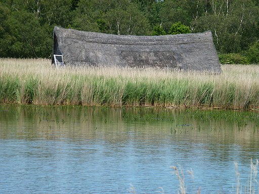
Thatched boat house on the mere. The mere is part of the Broads national park area, and the Horsey Estate is part of the Norfolk Coast Area of Outstanding Natural Beauty (AONB). Horsey Estate was purchased by the National Trust from the Buxton family in 1948. The Buxton family still manage the estate in partnership with the National Trust and it is thanks to the fact that nature conservation has always been a priority for the Buxtons that Horsey remains an important place for wildlife. In winter Horsey Mere is an internationally important wildfowl refuge and home to thousands of ducks including teal, wigeon and pochard.


