Instow to Appledore Circular Walk
![]()
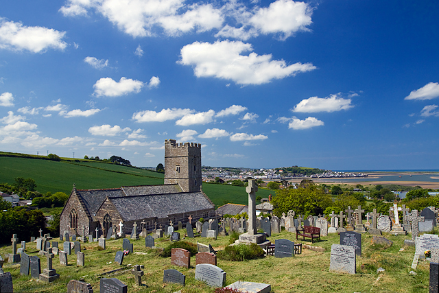
![]() This delightful Devon village sits in a lovely spot where the rivers Taw and Torridge meet. Notable features include a lovely riverside beach and a church dating back to the 13th century.
This delightful Devon village sits in a lovely spot where the rivers Taw and Torridge meet. Notable features include a lovely riverside beach and a church dating back to the 13th century.
This route from the village makes use of the Tarka Trail and the South West Coast Path to visit neighbouring Appledore on the opposite side of the river. During the summer months you can catch the ferry back at the end of the walk.
The walk starts from the village quay and takes you south along the River Torridge and the Tarka Trail to Bideford. Here you cross the river on Bideford Old Bridge and pick up the South West Coast Path on the other side. Follow the path north and it will take you past Northam to Appledore where you can pick up the seasonal ferry service to return you to Instow.
Postcode
EX39 4JJ - Please note: Postcode may be approximate for some rural locationsInstow Ordnance Survey Map  - view and print off detailed OS map
Instow Open Street Map  - view and print off detailed map
Instow OS Map  - Mobile GPS OS Map with Location tracking
Instow Open Street Map  - Mobile GPS Map with Location tracking
Walks near Instow
- Northam Burrows Country Park - Explore over 600 acres of grassy coastal plain, salt marsh, sand dunes and grasslands in this coastal country park in Devon
- Tarka Trail - This wonderful walk through Devon follows the path taken by Tarka the Otter in the book of that name
- Braunton Burrows - This circular walk explores the expansive sand dune system of a beautiful nature reserve on the North Devon Coast
- Westward Ho - Westward Ho! is a lovely seaside village in North Devon with a nice beach and some great coastal walking
- Codden Hill - This circular walk climbs to Codden Hill from the village of Bishop's Tawnton in North Devon
- Bideford - This attractive North Devon town has some lovely walks along the estuary of the River Torridge
- Great Torrington - This attractive historic town in Devon is a lovely place to explore on foot
- Appledore - This pretty Devon village is located at the mouth of the River Torridge, near the towns of Barnstaple and Bideford
- Crow Point - This walk visits the Crow Point Lighthouse near the town of Braunton on the North Devon coast
Pubs/Cafes
The Boathouse is in an excellent spot overlooking the beach and the river. They serve great seafood which you can enjoy from the splendid ‘Top Deck’ terrace. You can find them on Marine Parade at postcode EX39 4JJ.
Dog Walking
The riverside paths make for a fine dog walk and the Boathouse mentioned above is also dog friendly.
Photos
Appledore, viewed from the beach, at Instow. The village includes this iver beach and sand dunes, which are home to some rare species of orchid including the pyramid orchid.
During the height of the tourist season in the summer, the beach, also referred to as Instow Sands, is heavily frequented. The sandbanks at the mouth of the estuary cancel out most of the ocean swell, making the beach calm and ideal for families.
On the sands, there are many anchored boats. Many can only be reached at low tide or by dinghy or what is known as a "tender" in the area. Utilising the open space and calm waters, windsurfing and kitesurfing have grown in popularity. Canoeing and kayaking are also popular.
This picture is taken from the south of the village and shows the old quayside where you can catch the ferry. In the summer, the service connects Appledore slipway and Instow Quay across the Torridge estuary. There are two hours of service on either side of high tide. This service, which is aimed at both residents and visitors who use the Tarka Trail and South West Coast Path, has recently been provided on days when the estuary's water levels have been high enough as a not-for-profit endeavour.
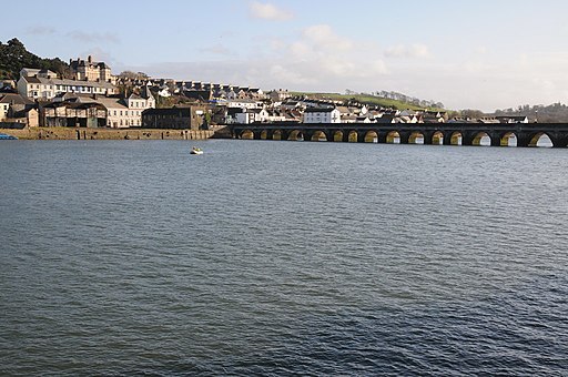
Bideford Long Bridge. The bridge spans the River Torridge near its estuary and connects the old part of the town, and formerly important river port, of Bideford on the left bank (west side) with East-the-Water on the right bank (east side). It is one of the longest mediaeval bridges in England, being 677 feet (222 yards) long with 24 arches.
Appledore river frontage. The village is the home of Appledore Shipbuilders, a lifeboat slipway and Hocking's Ice Cream, a brand of ice cream only sold in North Devon. Appledore is a charming fishing community with a rich maritime history and deilightful pastel homes. It has winding, narrow streets and colourful houses.
The village was founded on an ongoing tradition of fishing and boat building. For many years, Appledore served as a significant shipbuilding hub for the area, and many locals still find work in the village's sizable indoor shipyard. The North Devon Maritime Museum is now located in the village due to its long maritime history.


