Purbeck Circular Walk
![]()
![]() A long circular walk exploring the beautiful Isle of Purbeck in Dorset. The walk runs for just over 15 miles using sections of the Purbeck Way, South West Coast Path long distance footpaths.
Starting on the front in Swanage the route climbs north along the coast path to Ballard Down. From here you can enjoy wonderful views across the Purbecks, Poole Harbour, Studland and the Isle of Wight. You can also pick up the Purbeck Way here and follow it west to Corfe Castle. It's a splendid elevated path with great views for the whole way. You'll pass Ulwell where you'll have to climb down some steep steps before ascending past Round Down and Godlingston Hill. As you approach Corfe Castle there's fabulous views down to the ruins of the 11th century structure. The castle has a fascinating history being partially demolished in 1646 by the Parliamentarians during the English Civil War.
A long circular walk exploring the beautiful Isle of Purbeck in Dorset. The walk runs for just over 15 miles using sections of the Purbeck Way, South West Coast Path long distance footpaths.
Starting on the front in Swanage the route climbs north along the coast path to Ballard Down. From here you can enjoy wonderful views across the Purbecks, Poole Harbour, Studland and the Isle of Wight. You can also pick up the Purbeck Way here and follow it west to Corfe Castle. It's a splendid elevated path with great views for the whole way. You'll pass Ulwell where you'll have to climb down some steep steps before ascending past Round Down and Godlingston Hill. As you approach Corfe Castle there's fabulous views down to the ruins of the 11th century structure. The castle has a fascinating history being partially demolished in 1646 by the Parliamentarians during the English Civil War.
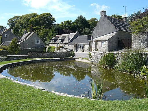
At the village you turn south to follow trails through the countryside to the village of Worth Matravers. It's a pretty spot with a delightful duck pond and a nice cafe for refreshments. From the village it is a short walk to the coast at Seacombe Cliff. Here you pick up the waymarked coast path and head east past Dancing Ledge to Anvil Point Durlston Country Park. In the park you can see the Anvil Point Lighthouse and a wide variety of flora and fauna, including 33 species of breeding butterfly, over 250 species of bird recorded, 500 wildflowers, 500 moths.
After passing through the park the route then descends back into Swanage to finish on the seafront.
To extend your walking on the Isle of Purbeck you could try the shorter Corfe Castle, Old Harry Rocks and Chapmans Pool walks.
Purbeck Circular Walk Ordnance Survey Map  - view and print off detailed OS map
Purbeck Circular Walk Open Street Map  - view and print off detailed map
Purbeck Circular Walk OS Map  - Mobile GPS OS Map with Location tracking
Purbeck Circular Walk Open Street Map  - Mobile GPS Map with Location tracking
Purbeck Walks
- Corfe Castle - This circular walk takes you around the Dorset village of Corfe Castle, visiting Corfe Common and passing the fascinating ruins of the 11th century ruined castle
- Old Harry Rocks - This circular walk visits the local landmark of Old Harry Rocks on the Dorset coast, near Studland
- Kimmeridge Bay to Chapmans Pool - This circular walk takes you along the South West Coast Path to two noteable highlights on the Jurassic Coast.
The beautiful Kimmeridge Bay is part of the Purbeck Marine Wildlife Reserve - Lulworth Castle - Explore the beautiful grounds of this 17th Century castle on this circular walk in Dorset
- Lulworth Range Walks - This circular walk in Dorset visits the deserted village of Tyneham before heading along the coast at Brandy Bay and Worbarrow Bay
- Wareham - The pretty Dorset town of Wareham has some lovely waterside walks along the rivers which pass through the area
- Langton Matravers - This pretty little village sits in a lovely spot close to the Dorset coast, near Swanage.
Pubs/Cafes
In Worth Matravers stop for refreshments at the excellent Square and Compass pub. The pub has a nice beer garden to sit out in during the summer months. It's also notable as a Grade II listed building, originally built in the 18th century as a pair of cottages before becoming a public house. The building includes a museum of fossils and other local artefacts and the pub is one of only nine nationally that has been included in every edition of CAMRA's Good Beer Guide.
Photos
Beach Huts along the seafront in Swanage. It was midweek and May but there were still a few holiday makers to be seen having their lunch in the huts which are available to rent throughout the season.
Bridleway up Godlingston Hill. A bridleway climbs up the Purbeck Chalk Ridge from Ulwell, on the south side of Godlingston Hill. The Purbeck Way follows this route to Corfe Castle.
Bridleway junction on Brenscombe Hill. The bridleway along the top of the Purbeck chalk ridge continues on into the distance - it is also the route of the Ballard Point-Corfe Castle branch of the Purbeck Way. To the right the bridleway descends through Brenscombe Little Wood to the Studland Road west of Rempstone Hall.


