Rhoscolyn Circular Walk
![]()
![]() This circular walk explores the area around the pretty Anglesey village of Rhoscolyn. The village is located south of Holyhead and is notable as the most southerly settlement on the island. For walkers there's a fine cliff top path with interesting geological features and excellent views to enjoy throughout. There's also lots of wildlife to see with grey seals in the water and stonechat, whitethroat and wheatear to look out for in the air.
This circular walk explores the area around the pretty Anglesey village of Rhoscolyn. The village is located south of Holyhead and is notable as the most southerly settlement on the island. For walkers there's a fine cliff top path with interesting geological features and excellent views to enjoy throughout. There's also lots of wildlife to see with grey seals in the water and stonechat, whitethroat and wheatear to look out for in the air.
The walk starts in the village and follows a footpath west to Tywrideen before turning south west to Rhoscolyn Head. You then pick up the Anglesey Coast Path and follow it south east past the mediaeval St Gwenfaen's Well to Borthwen. There's great views over the Llyn Peninsula from the dramatic rocky coast path. There's also lots of coves, two striking natural arches and views to the nearby Ynysoedd Gwylanod (seagull’s islands) and Rhoscolyn Beacon. From the attractive sandy Borthwen beach it is then just a short walk back to the village.
Postcode
LL65 2NJ - Please note: Postcode may be approximate for some rural locationsRhoscolyn Ordnance Survey Map  - view and print off detailed OS map
Rhoscolyn Open Street Map  - view and print off detailed map
Rhoscolyn OS Map  - Mobile GPS OS Map with Location tracking
Rhoscolyn Open Street Map  - Mobile GPS Map with Location tracking
Pubs/Cafes
Back in the village head to the White Eagle for some post walk refreshment. There's a lovely outdoor terrace here with splendid views to enjoy. They also serve excellent food including oysters freshly caught from the Menai. You can find them at postcode LL65 2NJ for your sat navs.
Dog Walking
The coastal paths make for a bracing walk with your dog. The White Eagle mentioned above is also dog friendly.
Further Information and Other Local Ideas
This route uses a section of the Anglesey Coast Path. You could continue along the trail to extend your walking in the area. Head north and it will take you to the lovely Trearddur Bay.
The Trearddur Bay to Rhoscolyn White Eagle Walk will take you to the bay from the White Eagle pub.
Heading east will take you to Cymyran Bay.
Head north and you could enjoy a more challenging walk to the summit of Holyhead Mountain.
For more walking ideas in the area see the Anglesey Walks page.
Cycle Routes and Walking Routes Nearby
Photos
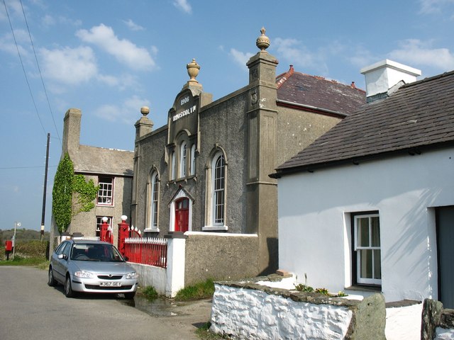
Capel Seion, Rhoscolyn Built in 1906, this is a Welsh Calvinistic Methodist chapel. It is a registered Grade II building. It replaced a 1805-built chapel and is also known as Capel Ty'n Rhos.
View down the back wall of the Porth Saint cove. Here the path runs along a ledge less than a metre wide. To reassure the faint-hearted a guard rail has been fixed along the edge of the precipice
The Dutch style Ty Craingc and the not so ancient cromlech. The burial chamber in the garden is a Victorian folly.
The former Rhoscolyn lifeboat station. Rhoscolyn's lifeboat station on Ynys Defaid ("sheep island") was operational between 1830 and 1929. On December 3rd 1920, five of the thirteen man crew of the lifeboat Ramon Cabrera were drowned in Caernarfon Bay in an attempt to rescue the crew of the Whitby registered SS Timbo, during which the lifeboat was twice capsized. A memorial to the five stands in the St Gwenfaen Churchyard.


