Royston Heath
![]()
![]() This large area of heathland is located just to the south west of the town of Royston in Hertfordshire. Also known as Therfield Heath it's a good sized area of common land on which sheep are still regularly grazed. The heath is in an elevated position, with some small hill climbs and great views over the Cam Valley countryside. Therfield Hill is the high point at 168 m (551 ft), with a water tower sitting on the summit.
This large area of heathland is located just to the south west of the town of Royston in Hertfordshire. Also known as Therfield Heath it's a good sized area of common land on which sheep are still regularly grazed. The heath is in an elevated position, with some small hill climbs and great views over the Cam Valley countryside. Therfield Hill is the high point at 168 m (551 ft), with a water tower sitting on the summit.
This circular walk starts from the car park off the Baldock Road, just west of Royston. From here you can pick up the trails heading west towards Jubilee Wood and the Fox Covert Nature Reserve. You then pass Church Hill before returning to the car park on different trails on the northern side of the heath.
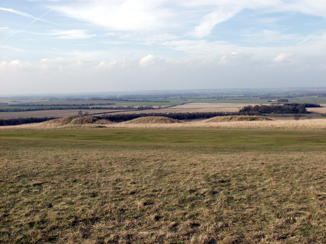
On the walk look out for several bronze age round barrows and lots of pretty wildflowers in the spring and summer months. Also look out for wildlife including the Chalkhill Blue butterfly fluttering around the flowers.
Both the Hertfordshire Way and the Icknield Way Path cross the heath. You can pick up either of these long distance, waymarked trails to continue your walking around Royston. You could follow the Icknield Way Path south, for example, to visit the village of Therfield itself.
Royston Heath Ordnance Survey Map  - view and print off detailed OS map
Royston Heath Open Street Map  - view and print off detailed map
Royston Heath OS Map  - Mobile GPS OS Map with Location tracking
Royston Heath Open Street Map  - Mobile GPS Map with Location tracking
Pubs/Cafes
The Heath Cafe Bar is a lovely place for some post exercise refreshment. They serve a good range of meals and snacks with a nice outdoor seating area for warmer weather. They're located on the eastern part of the heath at Baldock Road, SG8 5BG.
Dog Walking
The heathland and woodland are ideal for dog walking. It's a popular place so you will probably meet other owners with their pets. The on site cafe mentioned above is also dog friendly.
Further Information and Other Local Ideas
Just to the west there's the picturesque village of Ashwell to explore. There's a fine Tudor museum, a 14th century church and the interesting Ashwell Springs to see here. This biological Site of Special Scientific Interest, is notable as a source of the River Cam.
For a longer circular walk through the area see the Therfield Walk. This starts from the neighbouring village which lies just to the south. The attractive village is well worth a visit with its pretty village green and historic pub which dates back to 1700.
Just to the north is Shepreth where you could visit the Shepreth Wildlife Park. The park includes some exotic animals including red pandas, llamas, monkeys and tigers.
For more walking ideas in the area see the Hertfordshire Walks page.
Cycle Routes and Walking Routes Nearby
Photos
Five Hills barrows, Therfield Heath. The burial mounds on the right of the picture date to the Bronze Age; they are three of the five burial mounds that give the site its name. The mound in the left background is a Neolithic long barrow.


