Sawley Abbey
![]()
![]() This walk explores the area around the Lancashire village of Sawley, visiting the historic Sawley Abbey and a particularly scenic stretch of the River Ribble.
This walk explores the area around the Lancashire village of Sawley, visiting the historic Sawley Abbey and a particularly scenic stretch of the River Ribble.
The walk starts at the abbey car park and explores the abbey ruins before picking up a section of the Ribble Way and following it to neighbouring Chatburn.
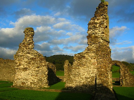
The abbey ruins date back to the 12th century and are now run by English Heritage. You can stroll around the grounds and view a number of information boards detailing the history of the site. The Grade I listed abbey was eventually disolved in in 1536, during the reign of King Henry VIII.
After making your way round the ruins head up to Sawley Bridge where you can enjoy some lovely views of the Ribble Valley.
To extend the walk continue south along the River Ribble to visit nearby Clitheroe where you can visit the old castle. To the east is Gisburn where there's a fine 18th century coaching inn and nice trails around Gisburn Park.
Postcode
BB7 4NH - Please note: Postcode may be approximate for some rural locationsPlease click here for more information
Sawley Ordnance Survey Map  - view and print off detailed OS map
Sawley Open Street Map  - view and print off detailed map
Sawley OS Map  - Mobile GPS OS Map with Location tracking
Sawley Open Street Map  - Mobile GPS Map with Location tracking
Pubs/Cafes
Head to the Spread Eagle Inn for some post refreshments. The splendid inn is located in a fine spot next to the river near the old bridge. On sunny days you can sit outside and enjoy a fine meal with views over the water.
Dog Walking
The abbey and the river are a pleasant place for a dog walk. You are requested to keep them on leads around the abbey ruins. The Spread Eagle mentioned above is also dog friendly.
Further Information and Other Local Ideas
To continue your walking around the village head south east and enjoy a climb to Pendle Hill. You can also pick up the long distance Pendle Way and enjoy a waterside walk around Black Moss Reservoir in this area.
The expansive Gisburn Forest is also not far away. You'll find miles of walking and cycling trails here.
Just to the west is the neighbouring village of Waddington. The village is very pretty and a regular winner of the Lancashire Best Kept Village awards. A stroll along the Waddington Brook and through the delightful Coronation gardens is recommended here.
To the north is Bolton by Bowland where there's two pretty village greens and views of the Skirden Beck.
For more walking ideas in the area see the Ribble Valley Walks page.
Cycle Routes and Walking Routes Nearby
Photos
Sawley Abbey or Salley Abbey - it is known by both names. Founded by William de Percy in 1147 as a Cistercian Monastery and operated for nearly 400 years - although never enjoying much wealth. This did not stop the tyrant Henry VIII dissolving the house, and executing the last abbot for his involvement in the Pilgrimage of Grace. The photograph shows what is left of the chapel.


