Shakespeare's Way Walk with OS Map
146 miles (235 km)
![]()
![]() This walk follows a route that Shakespeare may have taken when travelling between Stratford-upon-Avon and London. The path passes through the Chilterns, Oxford, Blenheim Park, the Cotswolds, the valley of the River Stour and the Thames Valley making for a beautiful and varied walk. There are lovely waterside stretches along the Oxford Canal and the River Thames into London.
This walk follows a route that Shakespeare may have taken when travelling between Stratford-upon-Avon and London. The path passes through the Chilterns, Oxford, Blenheim Park, the Cotswolds, the valley of the River Stour and the Thames Valley making for a beautiful and varied walk. There are lovely waterside stretches along the Oxford Canal and the River Thames into London.
The walk is waymarked with a logo of Shakespeare's head.
Please click here for more information
Shakespeare's Way Ordnance Survey Map  - view and print off detailed OS map
Shakespeare's Way Open Street Map  - view and print off detailed map
*New* - Walks and Cycle Routes Near Me Map - Waymarked Routes and Mountain Bike Trails>>
Shakespeare's Way OS Map  - Mobile GPS OS Map with Location tracking
Shakespeare's Way Open Street Map  - Mobile GPS Map with Location tracking
Cycle Routes and Walking Routes Nearby
Photos

Royal Shakespeare Theatre, Stratford-upon-Avon

Chalgrove, Oxfordshire

Four Pillars Hotel, Sandford-on-Thames

Hamble Brook, Hambleden

Deer in Stonor Park

Globe Theatre South Bank, London
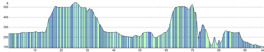
Elevation Profile