Sizewell Walks - to Thorpeness
![]()
![]() Sizewell is a small British fishing village located in East Suffolk. It falls under the jurisdiction of the civil parish of Leiston and is situated along the coastline of the North Sea, just to the north of the larger holiday village of Thorpeness. Positioned between the coastal towns of Aldeburgh and Southwold, it sits approximately 2 miles (3.2 km) east of the town of Leiston and is situated within the Suffolk Coast and Heaths Area of Outstanding Natural Beauty (AONB). The village is home to two nuclear power stations, one of which remains operational. There have been preliminary proposals for the construction of a third power station at this location.
Sizewell is a small British fishing village located in East Suffolk. It falls under the jurisdiction of the civil parish of Leiston and is situated along the coastline of the North Sea, just to the north of the larger holiday village of Thorpeness. Positioned between the coastal towns of Aldeburgh and Southwold, it sits approximately 2 miles (3.2 km) east of the town of Leiston and is situated within the Suffolk Coast and Heaths Area of Outstanding Natural Beauty (AONB). The village is home to two nuclear power stations, one of which remains operational. There have been preliminary proposals for the construction of a third power station at this location.
This walk from the village takes you along a section of the Suffolk Coast Path to visit the neighbouring village of Thorpeness. You can park in the public car park in Sizewell and then pick up the footpath heading south along the coast. Along the way you will pass Sizewell Marshes and Aldringham Walks, an RSPB run area with a wide variety of flora and fauna to see.
Please scroll down for the full list of walks near and around Sizewell. The detailed maps below also show a range of footpaths, bridleways and cycle paths in the area.
Sizewell Ordnance Survey Map  - view and print off detailed OS map
Sizewell Open Street Map  - view and print off detailed map
Sizewell OS Map  - Mobile GPS OS Map with Location tracking
Sizewell Open Street Map  - Mobile GPS Map with Location tracking
Walks near Sizewell
- Aldeburgh to Thorpeness - A circular walk from Aldeburgh to Thorpeness, taking in the Suffolk Coast, the wonderful Thorpeness Meare and the North Warren RSPB reserve.
Start from Aldeburgh at the Fort Green car park on the front - Suffolk Coast Path - A walk along the beautiful Suffolk coast from Felixstowe to Lowestoft
- Orford Ness - Follow the walking trails around this beautiful nature reserve on the Suffolk Coast
- Southwold - This lovely circular walk takes you from the coastal town of Southwold to the nearby village of Walberswick in the Suffolk Coast and Heaths Area of Outstanding Natural Beauty
- Aldeburgh to Snape Maltings - This walk visits the lovely Snape Maltings Nature Reserve from the coastal town of Aldeburgh in Suffolk
- Iken - This walk explores the area around the Suffolk village of Iken
- Leiston - This East Suffolk based town is located near the coast and the towns of Aldeburgh and Saxmundham.
- Aldringham - This Suffolk based village is located just south of Leiston in the Blything Hundred area of the county.
Further Information and Other Local Ideas
For more walking ideas in the area see the Suffolk Coast and Heaths Walks page.
Photos
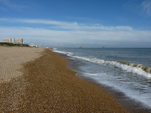
Sparkley sea, Sizewell beach.
The beach at Sizewell witnessed the historic landing of Henri Peteri and his brother Willem in September 1941. Departing from the Dutch town of Katwijk, the brothers embarked on a remarkable journey in a collapsible canoe, enduring 56 hours at sea. These courageous individuals, who escaped occupied Holland, were known as Engelandvaarders. Among them, approximately 1,700 reached England, with about 200 crossing the perilous North Sea. Regrettably, only eight out of 32 men attempting a canoe trip like the Peteri brothers succeeded in reaching the English coast.
In 2005, Henri Peteri initiated the construction of a memorial to honour the men who undertook the challenging journey across the North Sea by canoe. The memorial comprises a pair of crossed kayak oars, symbolizing their remarkable feat, along with a broken paddle that serves as a poignant tribute to those who tragically lost their lives during the voyage. In June 2009, the monument was unveiled by Henri's widow on Sizewell Beach, alongside the original kayak used in the historic expedition.
An inscription on the broken paddle reads:
In memory of the thirty-two young Dutchmen who tried to escape to England by kayak during World War II to join the Allied Forces. Eight of them reached the English coast. Only three survived the war. The last living survivor dedicated this memorial to his brothers in arms who were less fortunate. He reached England – and freedom – on this beach on 21 September 1941.
Looking north on Sizewell Beach. The village is home to two distinct nuclear power stations, namely the Magnox Sizewell A and the Pressurized Water Reactor (PWR) Sizewell B, which are prominently visible to the north of the village. Sizewell A has been decommissioned, ceasing electricity generation in 2006. The decommissioning process is anticipated to continue until 2027, with the site not expected to be fully cleared until 2098. Initially, there were plans to construct a third nuclear power station nearby. However, as of May 2013, significant doubts had arisen regarding the likelihood of reaching an agreement with the government. Nevertheless, in October 2021, the government announced new funding rules to facilitate financing through the Regulated Asset Base (RAB). "Welcome to Sizewell, twinned with Chernobyl" was a slogan adopted by anti-nuclear campaigners.
Track in Sizewell Belts Nature Reserve located to the west of the hamlet. Sizewell Marshes constitute a 260-acre (105.4 ha) biological Site of Special Scientific Interest located adjacent to Sizewell in Suffolk. Situated within the Suffolk Coast and Heaths Area of Outstanding Natural Beauty, it forms part of a larger 356-acre (144-ha) nature reserve managed by the Suffolk Wildlife Trust, known as Sizewell Belts. These unimproved wet meadows hold significant importance, designated by Natural England for their exceptional collections of invertebrates, featuring many nationally rare and scarce species. They are also nationally significant for their array of breeding birds typically found in wet grassland habitats. The aquatic flora present within the marshes is diverse, including species such as the nationally scarce soft hornwort and fen pondweed.
Sizewell Hall behind the beach. Sizewell Hall serves as a Christian conference centre located in Sizewell on the Suffolk coast, England. The estate is under the ownership of the Ogilvie family. Initially, in the 1950s, it functioned as a progressive school catering to children aged 7 to 13. Over time, it has gained historical significance due to its association with a notable taxidermy collection. Presently, the Christian conference centre is operated by Sizewell Hall Ltd, a registered charity. In 2007, the centre accommodated approximately 6,500 visitors, primarily comprising local church groups from East Anglia, national organizations, and a local youth organization called CYM from Ipswich. Notably, CYM has developed an activity holiday program for schoolchildren known as the African Village, situated within the Hall grounds.


