Wiveton Downs
![]()
![]() The Wiveton Downs are located close to the Norfolk coast, near Blakeney. The Nature Reserve is lovely peaceful place for a stroll with footpaths, gorse, an old quarry, woodland and grassland to explore.
The Wiveton Downs are located close to the Norfolk coast, near Blakeney. The Nature Reserve is lovely peaceful place for a stroll with footpaths, gorse, an old quarry, woodland and grassland to explore.
You can start the walk from the nature reserve car park off Bazzy Lane at a postcode of NR25 7SN for your sat navs. From here you can pick up various footpaths across the downs where there are nice views of the surrounding coast and countryside and lots of flora and fauna to look out for.
After exploring the downs head north east into Wiveton village where there's a splendid old church and a fine pub for post walk refreshment.
Postcode
NR25 7SN - Please note: Postcode may be approximate for some rural locationsWiveton Downs Ordnance Survey Map  - view and print off detailed OS map
Wiveton Downs Open Street Map  - view and print off detailed map
Wiveton Downs OS Map  - Mobile GPS OS Map with Location tracking
Wiveton Downs Open Street Map  - Mobile GPS Map with Location tracking
Pubs/Cafes
Head into the village and you could visit the splendid Wiveton Bell. There's a lovely outdoor seating area with fine views of the noteworthy old church in the village. You can find them at postcode NR25 7TL for your sat navs.
Dog Walking
The downs are a lovely place for a peaceful dog walk and the pub mentioned above is also dog friendly.
Further Information and Other Local Ideas
To continue your walking in the area you could try the Blakeney Circular Walk or head to the Blakeney Point Nature Reserve and look out for the seals on the coast. There's also the popular Blakeney to Cley Walk to try.
For more walking ideas in the area see the Norfolk Walks page.
Cycle Routes and Walking Routes Nearby
Photos
The Blakeney Esker SSSI. An information board by the footpath informs about this geological feature which was created during the Quaternary period by melt water from glaciers forming a tunnel beneath the ice, and carrying large quantities of sand, gravel and flint that the glaciers had scraped out. When the glaciers retreated these tubes of sediment were left behind leaving the features visible today. The southern end of the Esker (Wiveton Downs) represents one of the very best examples of an Esker formation to be seen anywhere, and this is the reason for its SSSI designation.
Gorse on the downs. Wiveton Downs is a Site of Special Scientific Interest of geological and wildlife interest. The view is from the north side of the ridge looking across towards Wiverton and the coast beyond. View north from the Downs. A Rowan tree in berry adds colour to the scene. In the background can be seen the tower of the church of St Nicholas, Blakeney.
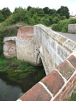
Wiveton Bridge. This old bridge spanning the River Glaven is located a short distance south of St Mary's church - it has a single arch and dates from the 15th century. A chapel once used to stand close by the bridge and it is believed that the brick buttress platform on one corner of the bridge might be associated with it. No trace remains of the chapel.
The Wiveton Bell Public house adjoining the village green, beside Blakeney Road. The village of Wiveton is situated on the west bank of the River Glaven, about one kilometre distant, across the river, from the village of Cley next the Sea. Wiveton has a population of about 160; some of the houses are second homes with the owners absent for most of the year. Until the 17th century, when the River Glaven was still navigable, Wiveton had a harbour, the outline of which can be seen in the fields separating it from Cley. There is a medieval bridge a short distance south of the church. The village made headlines in 1779, when the then newly-appointed Rector, James Hackman, was hanged for murdering Martha Ray, the mistress of John Montagu, 4th Earl of Sandwich (who is credited with inventing the sandwich).


