Elgin to Nairn
28 miles (45 km)
![]()
![]() Follow National Cycle route 1 from Elgin to Nairn and enjoy splendid views of the Moray Firth and Findhorn Bay.
Follow National Cycle route 1 from Elgin to Nairn and enjoy splendid views of the Moray Firth and Findhorn Bay.
The ride starts with a nice off road stretch along signed National Cycle Route 1 and the River Lossie in Elgin, before quiet country roads take you onto Kinloss where you can see the historic ruined abbey and the beautiful Findhorn Bay. You then continue through Forres and Dyke, with views of the Findhorn River and some lovely wooded sections, before arriving at the fishing port of Nairn with its attractive harbour. The ride finishes with a pleasant traffic free run along the River Nairn in Nairn.
Elgin to Nairn Ordnance Survey Map  - view and print off detailed OS map
Elgin to Nairn Open Street Map  - view and print off detailed map
Elgin to Nairn OS Map  - Mobile GPS OS Map with Location tracking
Elgin to Nairn Open Street Map  - Mobile GPS Map with Location tracking
Further Information and Other Local Ideas
East of Elgin there's Loch Oire and Loch Na Bo to visit.
Cycle Routes and Walking Routes Nearby
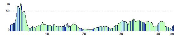
Elevation Profile