Long Eaton to Langley Mill
![]()
![]() This lovely ride starts at the Nutbrook Trail just north of Long Eaton rail station following it north to Langley Mill.
This lovely ride starts at the Nutbrook Trail just north of Long Eaton rail station following it north to Langley Mill.
The trail follows the Erewash Canal and also includes a section through Shipley Country Park which makes it ideal for a leisurley afternoon's cycling.
The finish point is Langley Mill rail station.
Long Eaton to Langley Mill Ordnance Survey Map  - view and print off detailed OS map
Long Eaton to Langley Mill Open Street Map  - view and print off detailed map
Long Eaton to Langley Mill OS Map  - Mobile GPS OS Map with Location tracking
Long Eaton to Langley Mill Open Street Map  - Mobile GPS Map with Location tracking
Pubs/Cafes
The Nutbrook Coffee Shop is located right on the Nutbrook Trail, minutes from Shipley Park. It's about a 30 minute walk from the Shipley Country Park Visitor Centre (1.7 miles), following the Nutbrook Trail past Osbournes Pond. There's a great selection of freshly made sandwiches, panini’s, pies, pasties and a fantastic range of cakes. There's also a very pretty garden area to sit out in and it's also dog friendly. You can find it on the trail at postcode DE7 6BQ for your sat navs.
Cycle Routes and Walking Routes Nearby
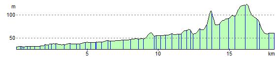
Elevation Profile