 |
Wirral Way |
 |
|
Description |
 This is a terrific walk or cycle ride that runs along a pleasant traffic free path through the Wirral Countryside and along the coastal estuary of theĀRiver Dee. It follows the track bed of part of the former Birkenhead Railway route from Hooton to West Kirby. This is a terrific walk or cycle ride that runs along a pleasant traffic free path through the Wirral Countryside and along the coastal estuary of theĀRiver Dee. It follows the track bed of part of the former Birkenhead Railway route from Hooton to West Kirby.
You start off at Hooton Railway Station near Ellesemere Port and head towards Neston entering the lovely Wirral Country Park on the way. The path then heads along the beautiful Wirral coastline passing Heswall and Thurstaston before finishing at West Kirby.
Along the route you'll pass very close to Royden Park and Caldy Hill, both of which are worth a small detour if you have time. At Royden Park you will find woodlands, meadows, heathland and two meres with an abundance of birdlife. You can also explore Thurstaston Common and climb Thurstaston Hill here.
At West Kirby you'll pass Caldy Hill where there are nice woodland trails and views over the River Dee, Hilbre IslandĀand theĀIrish Sea.
Near Neston you pass the pretty coastal village of Parkgate which is well worth a visit. From the attractive coastal parade there are views across the marshland of the Dee and huge variety of birdlife to look out for.
The long distance Wirral Circular Trail also passes the area. Pick up this 37 mile trail to explore the rest of the peninsula.


|
|
|
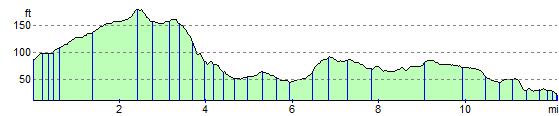
Distance | 12 miles (19 km) |
|
|
Joining Routes | Hilbre Island, Parkgate Circular Walk, Royden Park, Caldy Hill, Wirral Country Park, Chester to Neston, Liverpool to Neston, North Cheshire Way, Rivacre Valley Country Park, Wirral Circular Trail, Heswall Dales, Thurstaston Common and Coast, Burton Marshes Greenway, National Cycle Route 56 |
|
|
Memory Map Route | Wirral Way.mmo (right click - 'Save As') |
|
|
GPX File | Wirral Way.gpx (right click - 'Save As')
| |
|
Elevation | 
|
|
|
Route Photos |  |  |  |  | On the path near Wilaston | Pond at Wirral Country Park | Neston | View of the path at Heswall |  |  | | | Coast at Thurstaston | Coast at West Kirby | | |
 Photos are copyrighted by their owners Photos are copyrighted by their owners
|
|
|
Map (Route in Red)
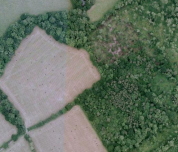
Aerial Photo View of this route
|
|
|
|
Video | |
|