North Cheshire Way with OS Map and GPX
![]()
![]() Starting at Hooton Station, near Ellesmere Port, follow the North Cheshire Way through Frodsham, Northwich, Knutsford and Wilmslow to the finish point at Disley.
Starting at Hooton Station, near Ellesmere Port, follow the North Cheshire Way through Frodsham, Northwich, Knutsford and Wilmslow to the finish point at Disley.
Highlights on the walk include:
- Climbing Helsby Hill near Frodsham. The hill includes and Iron Age Hillfort with wonderful views over the Cheshire Plain, North Wales and the Mersey Estuary.
- A long riverside section along the River Weaver from Frodsham to Northwich.
- Tatton Park, near Knutsford. This historical estate contains a mansion, Tatton Hall, a manor house dating from medieval times, Tatton Old Hall, gardens, a farm and a deer park of 2,000 acres.
- A section alongside Manchester Airport near Wilmslow.
- Following the River Bollin through the delightful Styal Country Park and Woods in Wilmslow
- The wonderful Lyme Park (video below) with its mansion house and Medieval deer park. This can be found near Disley towards the end of the route
- Canalside sections along the Shropshire Union Canal and the Maccesfield Canal
The walk is waymarked with a yellow arrow on a black disc.
North Cheshire Way Ordnance Survey Map  - view and print off detailed OS map
North Cheshire Way Open Street Map  - view and print off detailed map
*New* - Walks and Cycle Routes Near Me Map - Waymarked Routes and Mountain Bike Trails>>
North Cheshire Way OS Map  - Mobile GPS OS Map with Location tracking
North Cheshire Way Open Street Map  - Mobile GPS Map with Location tracking
Pubs/Cafes
In Prestbury Ye Olde Admiral Rodney is a historic pub worthy of some investigation. This charming former coaching inn dates back to the 17th century and includes many period features such as low ceilings and panelled walls. You can find them on New Road with postcode SK10 4HP for your sat navs. The pub is also dog friendly if you have your canine friend with you.
The village itself is also worth exploring with several listed timber framed buildings and a picturesque churchyard. Look out for famous faces too as it is one of the most desirable places to live in the north with many celebrities and footballers purchasing expensive properties in the area. Just north of the village you'll also find the Grade II listed Mottram Hall. The estate includes 270 acres of beautiful landscaped gardens surrounding a fine 18th century hall which now operates as a hotel.
Further Information and Other Local Ideas
Near Northwich you could stop off at the noteworthy Arley Hall. Here you'll find a fine stately home and some stunning gardens which are amongst the best in the country. The hall is located on the route at postcode CW9 6NA for your sat navs. For more walking ideas in the area see the Cheshire Walks page.
Cycle Routes and Walking Routes Nearby
Photos

Pott Shrigley waymarker post. View along the NCW towards Birchencliff from the junction with Moorside Lane. Fine views of the Cheshire Plain on the descent ahead.

Morning at Acton Bridge. A selection of preserved boats moored at Acton Bridge after a steam rally. The 'Kerne' is a steam tug which worked the London docks; the large boat in the further group is a traditional Weaver Navigation vessel.

Giants Castle bridge leading over the River Bollin into Giants Castle Wood near Styal.

Swans near Morley Hall. In the field, next to the railway line, just out of shot to the left, is a small pond. Five swans were grazing just as two more flew over head, to land nearby. Little Barrow is in the distance, with the stile on the right.

View of Footpath towards Catton Hall. The footpath hugs the hedge of this field before joining the private road. Since 2006 this has made up part of the North Cheshire Way.

Comberbach. The trail passes just to the west of Pickmere Lake and Budworth Mere in Great Budworth. It then crosses these fields before reaching the Marbury Road. Beyond the woods on the left lies Marbury Country Park.

Adlington, on the trail near Wych Wood. Although the photo is taken from the edge of the square it looks back SE along the footpath just walked from Harrop Green.

Prestbury: field pond and sheep. This is on the almost level lower land between the River Bollin (behind) and the River Dean (ahead).
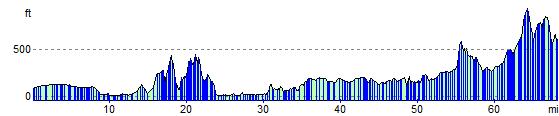
Elevation Profile