Bakewell Loop
9.3 miles (15 km)
![]()
![]() This lovely short ride first follows the Monsal Trail through the Derbyshire countryside before returning to Bakewell via Ashford in the Water.
This lovely short ride first follows the Monsal Trail through the Derbyshire countryside before returning to Bakewell via Ashford in the Water.
The Monsal Trail is an off road track with splendid views of the River Wye and the peak district scenery - it is a must see if visiting the area for cycling.
Bakewell Loop Ordnance Survey Map  - view and print off detailed OS map
Bakewell Loop Open Street Map  - view and print off detailed map
Bakewell Loop OS Map  - Mobile GPS OS Map with Location tracking
Bakewell Loop Open Street Map  - Mobile GPS Map with Location tracking
Cycle Routes and Walking Routes Nearby
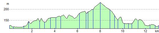
Elevation Profile