Buxton to Matlock
31.1 miles (50 km)
![]()
![]() A challenging but rewarding route taking you through the heart of the Peak District.
A challenging but rewarding route taking you through the heart of the Peak District.
Highlights include views of the Rivers Wye and Derwent and Chatsworth Park - an attractive country house home to the Dukes of Devonshire. There is also a run along the lovely Monsal Trail which follows the River Wye. Attractive towns on the route inlclude Ashford in the Water and Bakewell.
The route then finishes in the county town of Matlock.
Buxton to Matlock Ordnance Survey Map  - view and print off detailed OS map
Buxton to Matlock Open Street Map  - view and print off detailed map
Buxton to Matlock OS Map  - Mobile GPS OS Map with Location tracking
Buxton to Matlock Open Street Map  - Mobile GPS Map with Location tracking
Cycle Routes and Walking Routes Nearby
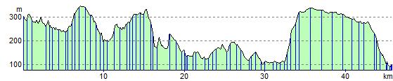
Elevation Profile