Birdoswald Walk
![]()
![]() This circular walk explores the fascinating Birdoswald Roman Fort on the Cumbrian section of Hadrian's Wall. The route first explores the fort before following footpaths to other local highlights including the River Irthing, a Roman Quarry, nearby woodland and the village of Gilsland.
This circular walk explores the fascinating Birdoswald Roman Fort on the Cumbrian section of Hadrian's Wall. The route first explores the fort before following footpaths to other local highlights including the River Irthing, a Roman Quarry, nearby woodland and the village of Gilsland.
The walk starts from the English Heritage car park and visitor centre. The fort is the most impressive of the remaining defences along the Wall today. It dates back to AD 122 and includes a well preserved eastern gate, fort walls and watch towers. There's also a museum with an interactive exhibition which details the history of the fort.
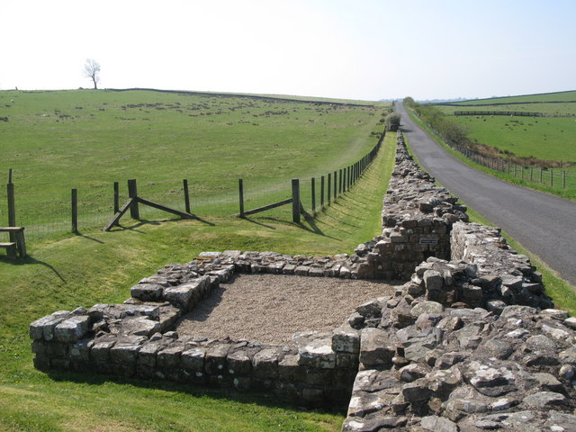
After exploring the fort you can pick up the Hadrian's Wall Path and follow the waymarked trail along the wall to Turrets 49b and 50b.
Soon after you come to Combcrag Wood and a Roman Quarry. Here you turn south through the woods on a path which runs along the River Irthing to Chapelburn. Here you'll pass another Roman Fort and cross the Irthing before heading east along a country lane to Upper Denton where you'll pass the remains of the old Bastle or fortified farmhouse.
The route continues east to bring you into the village of Gilsland. The village is in an interesting spot straddling the border between Cumbria and Northumberland, with most of its houses in Northumberland. From the village you can visit the lovely Crammel Linn waterfall which sits in a wonderful river gorge to the north.
After exploring the village the route heads west to cross an old Roman Bridge over the Irthing. Shortly after you return to Birdoswald where the walk finishes.
You can virtually explore the fort on the google street view link below.
Postcode
CA8 7DD - Please note: Postcode may be approximate for some rural locationsPlease click here for more information
Birdoswald Ordnance Survey Map  - view and print off detailed OS map
Birdoswald Open Street Map  - view and print off detailed map
Birdoswald OS Map  - Mobile GPS OS Map with Location tracking
Birdoswald Open Street Map  - Mobile GPS Map with Location tracking
Explore the Area with Google Street View 
Pubs/Cafes
There's a good English Heritage cafe selling a decent range of meals and snacks. There's seating indoors and some picnic benches outside if the weather is good.
If you prefer a pub then you could stop off at The Samson Inn in Gisland. They have a good menu and a fine range of ales. There's also a sunny beer garden and accommodation if you need to stay over. You can find it at postcode CA8 7DR for your sat navs.
Dog Walking
The area makes for a great dog walk although you're required to keep them on leads in the Birdoswald fort area. The Samson Inn mentioned above is also dog friendly.
Further Information and Other Local Ideas
If you head east along the wall you'll come to another of the major highlights at Housesteads. There's another well preserved forther with a barracks block, hospital, Commander's House, granaries and communal toilets which are all still visible today.
Just east of Gisland you can pick up the Pennine Way and follow it south across Blenkinsopp Common to the interesting Lambley Viaduct. Near here you can also pay a visit to Featherstone Castle, a Grade I listed Gothic style country mansion.
In nearby Haltwhistle you can pick up the
South Tyne Trail. This shared cycling and walking trail will take you toward Slaggyford.
If you head a few miles west along the wall there's another historic local highlight at Lanercost Priory. The English heritage run site was originally founded in 1169 as an Augustinian monastery. Today the substantial priory ruins are well worth a visit for the fascinating history and architecure.
For more walks in the area see the North Pennines Walks and Northumberland National Park Walks pages.
Cycle Routes and Walking Routes Nearby
Photos
Birdoswald (Banna). Banna means "horn" or "peak", an appropriate name for this fort sitting on its promontory above the River Irthing.
Remains of Bastle at Upper Denton. Scheduled Monument 27671. Upper Denton is a small village in northern Cumbria, not far from the Scottish border. The Bastle, a ruined late medieval fortified house, once served as the vicarage for the nearby church.The structure had deteriorated seriously and parts had collapsed. Negotiations with English Heritage resulted in an offer to grant-aid 80 per cent of the work, as a result of which the Bastle has been repaired.
Millennium Footbridge over the River Irthing by Hadrian’s Wall near Gilsland. The footbridge over the River Irthing links the fort at Birdoswald to the remains of the Wall at Gilsland. The bridge was the first of a suite of smaller bridges constructed on the wall. It was designed by Napper Architects with Arup and was lowered into place by an RAF helicopter. It is close to the extensive foundations of the Willowford Roman bridge.


