Housesteads Circular Walk
![]()
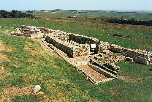
![]() Visit the fascinating Housesteads Roman Fort on this circular walk around Hadrian's Wall in the Northumberland National Park. The fort dates from AD 124 and includes a barracks block, hospital, Commander's House, granaries and communal toilets which are all still visible today.
Visit the fascinating Housesteads Roman Fort on this circular walk around Hadrian's Wall in the Northumberland National Park. The fort dates from AD 124 and includes a barracks block, hospital, Commander's House, granaries and communal toilets which are all still visible today.
You can start the walk from the Housesteads car park on the Military Road just south of the fort. You then climb steadily up to the fort where you can explore the buildings and enjoy wide ranging views over the surrounding countryside, woodland and hills. The walk then heads west along Housesteads Crags and Hotbank Crags where you can actually walk on a section of the wall. Just before Crag Lough you turn north and then east, following another footpath past Ridley Common and Broomlee Lough. After rounding King's Wicket, you pass Milecastle 36, King's Hill and Clew Hill before returning to the fort and the car park.
To extend your walk you can continue west along the path and visit the iconic Sycamore Gap. The famous tree was voted England's tree of the year in 2016. It is located just over a mile west of Housesteads near to the pretty Crag Lough.
Another option is to pick up the Pennine Way and follow it between Broomlee Lough and Greenlee Lough towards Haughton Common. Greenlee Lough is also a nature reserve and one of the most significant wetland sites in the UK.
If you head east along Hadrian's Wall Path you will soon come to Carrawburgh which was the site of a 3½ acre auxiliary fort.
You can virtually explore the fort and the Hadrian's Wall Path using the google street view link below! You can see all the buildings and the wonderful views over the national park from the fort's high points.
Postcode
NE47 6NN - Please note: Postcode may be approximate for some rural locationsHousesteads Ordnance Survey Map  - view and print off detailed OS map
Housesteads Open Street Map  - view and print off detailed map
*New* - Walks and Cycle Routes Near Me Map - Waymarked Routes and Mountain Bike Trails>>
Housesteads OS Map  - Mobile GPS OS Map with Location tracking
Housesteads Open Street Map  - Mobile GPS Map with Location tracking
Explore the Area with Google Street View 
Pubs/Cafes
Head west of the site and you can visit The Twice Brewed Inn near Sycamore Gap. Here you can enjoy home-cooked meals in a comfy, cosy restaurant with a roaring fire. There's car parking, cycle storage and a nice beer garden for warmer weather too. They also offer tours of their brew house in an area with a brewing tradition dating back nearly 2,000 years. If you need to stay over they have several rooms with fine views over the area. You can find the pub near the Gap at a postcode of NE47 7AN.
Dog Walking
The area is popular with dog walkers but you are advised to please keep them on short leads. The Twice Brewed Inn mentioned above is also dog friendly.
Further Information and Other Local Ideas
If you head west along the wall you will come to one of the other major highlights at Birdoswald. There's another well preserved fort and an excellent English Heritage Visitor Centre and museum here. There's also some nice trails through the Irthing Valley and visit to the village of Gilsland on the border with Cumbria. Here you can visit the splendid Crammel Linn waterfall which sits in a wonderful river gorge north of Gilsland.
Many people visit the fort from the Steel Rigg car park just west of the site. The Steel Rigg Circular Walk will take you to the tree at Sycamore Gap before visiting Housesteads. It takes you along an interesting section of the wall with views of the Crag Lough on the way.
Just south of the site you'll find another of the area's walking highlights at the lovely Allen Banks and Staward Gorge. This National Trust owned area includes lovely peaceful river and woodland trails with lots of wildlife to see. Near here you can also pick up the Haydon Bridge Walk from the riverside village. The walk will take you to the historic Langley Castle which dates from the 14th century. In the village itself there's a fine 17th century inn and a noteworthy 14th century bridge over the river to see too.
You could visit the site from nearby Bardon Mill train station. The village is located just to the south close to the Vindolanda Roman Fort.
For more walking ideas in the area see the Northumberland Walks and Northumberland National Park Walks pages.


