Crowcombe Walks
![]()
![]() This Somerset based village makes a fine start point for exploring the surrounding Quantocks Hills and Brendon Hills.
This Somerset based village makes a fine start point for exploring the surrounding Quantocks Hills and Brendon Hills.
This circular walk from the village uses part of the Macmillan Way and the Quantock Greenway to climb to some of the Quantock Hills located near to the settlement. On the way you'll climb to Black Hill, Thorncombe Hill and Bicknoller Hill while enjoying some wonderful views from the high points.
The walk starts in the village where you can follow the Macmillan Way south east to Little Quantock Combe and Fire Beacon. The trail will take you north west along Crowcombe Park, climbing to Black Hill, Halsway Post, Lowsey Thorn, Black Ball Hill, Thorncombe Hill and Bicknoller Hill. On this section look out for lots of pretty heather in the summer months. There are also some splendid views from this ridge top part of the route.
At Bicknoller village you turn south east, following the Quantock Greenway to Higher Halsway where you will pass the impressive 15th century Halsway Manor. You then continue pass Lower Halsway and Lawford before returning to the village.
To continue your walking around Crowcombe head south to climb to the highest point in the Quantocks at Wills Neck.
Postcode
TA4 4AD - Please note: Postcode may be approximate for some rural locationsCrowcombe Ordnance Survey Map  - view and print off detailed OS map
Crowcombe Open Street Map  - view and print off detailed map
*New* - Walks and Cycle Routes Near Me Map - Waymarked Routes and Mountain Bike Trails>>
Crowcombe OS Map  - Mobile GPS OS Map with Location tracking
Crowcombe Open Street Map  - Mobile GPS Map with Location tracking
Walks near Crowcombe
- Wills Neck - Climb to the highest point in the Quantock Hills on this circular walk in Somerset
- Quantock Greenway - A splendid figure of eight walk through the stunning Quantock Hils AONB.
The walk begins at the pretty village of Broomfield which is the highest village on the Quantock Hills - Brendon Hills - Explore the Brendon Hills range on this challenging walk in the Exmoor National Park
- Hawkridge Reservoir - Enjoy a circular walk around this pretty reservoir in the Quantock Hills area of Somerset
- Nether Stowey - This picturesque Quantocks village has some nice country and woodland trails to the west and south of the settlement
- Holford - This lovely Quantocks village has some nice walks to try through the surrounding woodland and countryside
- Kilve Beach and East Quantoxhead - This circular walk explores a beautiful area of coast and countryside in the Quantocks.
- Great Wood Quantocks - Enjoy miles of cycling and walking trails in this large area of woodland in the Quantocks
- Cothelstone Hill - Enjoy heathland, woodland and wonderful views on this circular walk in the Quantocks
- Lydeard Hill - Climb to Lydeard Hill in the Quantocks an enjoy splendid views over the surrounding countryside on this short circular walk.
You can start your walk from the Lydeard Hill car park on Lydeard Hill Road - West Bagborough - This Quantocks village is in a superb location for starting a walk to the surrounding hills
Pubs/Cafes
Back in the village you can enjoy some post walk rest and refreshments at The Carew Arms. The historic pub dates back to the 17th century and has a charming interior with an ancient inglenook fire. Outside there's a splendid large garden area with views towards the Brendon Hills. You can find them at postcode TA4 4AD for your sat navs.
Further Information and Other Local Ideas
Just to the east you'll find miles of peaceful woodland trails around Great Wood.
The long distance Samaritans Way South West passes through the settlement too.
For more walking ideas in the area see the Quantocks Walks page.
Photos
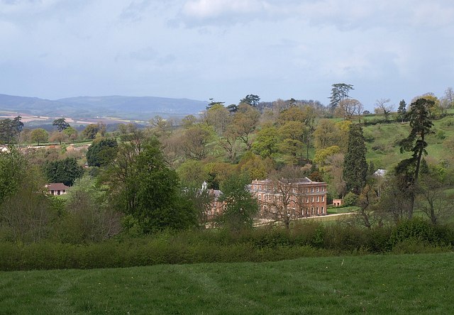
Crowcombe Court. “The house is of brick and the finest of its date in Somerset south of the Bath area” (Pevsner, South & West Somerset, 1958). The date is 1724-39. "Begun by Thomas Parker, finished by Nathaniel Ireson of Wincanton." The building straddles a gridline but almost all of the two visible facades is in ST1436. However, the stable block to the left of the main house is in ST1336. Seen from the lane from Little Quantock.
Wall and pier, Halsway Manor. With the backdrop of this is part of the manor, the listed surrounding wall, with fluted pilasters and volutes on the pier. Above the manor is Halsway Wood, on the steep slopes of Thorncombe Hill on the Quantocks. The manor is England's National Centre for Traditional Music, Dance and Song. It's notable as the only residential folk centre in the UK. The eastern end of the building dates from the 15th century with the western end as an addition in the 19th century.


