Emsworth to Langstone and Mill Pond Harbour Walk
![]()
![]() This attractive coastal town has some lovely walks along Chichester Harbour to try. This route takes you from Emsworth to Langstone Harbour along a splendid waymarked, coastal path.
This attractive coastal town has some lovely walks along Chichester Harbour to try. This route takes you from Emsworth to Langstone Harbour along a splendid waymarked, coastal path.
The walk starts at the train station and heads south to the marina, the photogenic mill pond and the old tide mill. You can then pick up a section of the Wayfarer's Walk and Solent Way long distance trails. These waymarked trails will take you west along a lovely section of the harbour, where you can look out for a wide variety of birds. Keep your eyes peeled for redshank, dunlin, shelduck and curlew as you make your way along the coastal path.
After a while you pass the noteworthy remains of Warblington Castle. Originally home to a medieval manor, today, the turret, the arch of the gate and the drawbridge support in the moat still survive. The site has an interesting history having previously been the home of the Countess of Salisbury, who was executed at the Tower of London in 1541 under the orders of Henry VIII due to her disapproval of his marriage to her friend Catherine of Aragon.
The route continues west to Langstone Harbour. Here you will find mudflats, salt water lagoons and a windmill. Together with Chichester Harbour, which is at the other (eastern) side of Hayling Island Langstone Harbour is designated as a Special Protection Area for wildlife. It's another popular spot for birdwatchers so make sure to bring your binoculars for this walk.
The route finishes at the quay where you can enjoy refreshments and harbour views at the local pub, the Royal Oak.
To extend the walk cross Langstone Bridge to visit Hayling Island. Our walk around the island visits Sinah Common, Ferry Point, South Hayling, Eaststoke Beach and the Sandy Point Nature Reserve.
You could also continue west along the Solent Way to Farlington Marshes where you'll find a beautiful nature reserve with more wildlife to see.
The Sussex Border Path passes through the town. Pick this up and head south to visit Thorney Island. This links with our Chichester Harbour Walk which further explores the AONB, visiting the delightful quay at Bosham.
Emsworth Ordnance Survey Map  - view and print off detailed OS map
Emsworth Open Street Map  - view and print off detailed map
Emsworth OS Map  - Mobile GPS OS Map with Location tracking
Emsworth Open Street Map  - Mobile GPS Map with Location tracking
Pubs/Cafes
The Ship Inn in Langstone is superbly positioned for a pit stop. The family-friendly seaside pub overlooks Sweare Deep and Emsworth Harbour. There's a fantastic outdoor area right next to the water and a cosy interior with a warming fire. You can find the pub in Langstone with a postcode of PO9 1RD for your sat navs.

Pictured above the Ship Inn at Langstone. A great place to relax outside with a drink on a summer day.
Cycle Routes and Walking Routes Nearby
Photos
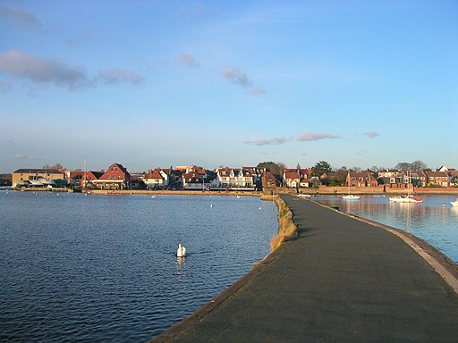
Emsworth from the Mill Pond wall. The pond is a popular place for a walk in the town. The Westbrook Stream which flows into the millpond from the north, brings a regular flow of small fish which attract diving birds and gulls. There's also a resident flock of non-breeding Mute Swans and plenty of ducks to feed. Other birds you may see include Tufted Ducks, Pochard, Goldeneye, Cormorant, Little Grebe, Great Crested Grebe and Red-breasted Mergansers
Emsworth Tide Mill. The tide mill dates to the 18th century and is Grade II listed. The building has recently been modernised (with new dormers) for use as a sailing club. The town has a basin for yachts and fishing boats, which fills at high tide and can be emptied through a sluice at low tide. It is now used for recreational sailing, paddle boarding, kayaking and swimming.
Warblington castle tower. These ruins are located on the walk in the small village of Warblington, just to the west of Emsworth. Most of the original moated castle was destroyed during the English Civil War, leaving only a single gate tower, part of a wall, and a gateway. The property is privately owned and does not allow for public access. It is a grade II* listed building and a scheduled Monument. The 12th century St Thomas à Becket Church is also located in the village and worthy of some investigation.


