Falls of Clyde Circular Walk Map
![]()
![]() Enjoy woodlands, waterfalls and a walk along the River Clyde in this delightful nature reserve in Lanark. The falls comprise of Bonnington Linn, Corra Linn, Dundaff Linn, and the lower falls of Stonebyres Linn. Corra Linn is the highest, with a fall of 84 feet. The Clyde Gorge is a haven for wildlife - look out for peregrine falcons, badgers, bats, roe deer, otters, kingfishers and over 100 species of bird. There's an excellent Visitor Centre with a lot of information on the falls and the animals that dwell there.
Enjoy woodlands, waterfalls and a walk along the River Clyde in this delightful nature reserve in Lanark. The falls comprise of Bonnington Linn, Corra Linn, Dundaff Linn, and the lower falls of Stonebyres Linn. Corra Linn is the highest, with a fall of 84 feet. The Clyde Gorge is a haven for wildlife - look out for peregrine falcons, badgers, bats, roe deer, otters, kingfishers and over 100 species of bird. There's an excellent Visitor Centre with a lot of information on the falls and the animals that dwell there.
The Clyde Walkway long distance walk path runs through the reserve so you could pick this up and continue your walk along the River Clyde. Also nearby is Lanark Moor Country Park where you can enjoy a walk around Lanark Loch.
Postcode
ML11 9DB - Please note: Postcode may be approximate for some rural locationsFalls of Clyde Nature Reserve Ordnance Survey Map  - view and print off detailed OS map
Falls of Clyde Nature Reserve Open Street Map  - view and print off detailed map
*New* - Walks and Cycle Routes Near Me Map - Waymarked Routes and Mountain Bike Trails>>
Falls of Clyde Nature Reserve OS Map  - Mobile GPS OS Map with Location tracking
Falls of Clyde Nature Reserve Open Street Map  - Mobile GPS Map with Location tracking
Further Information and Other Local Ideas
South of Lanark there's a popular climb to Tinto Hill to try. The hill is an excellent local viewpoint with fine views over the hills and countryside of the Southern Uplands. The hill top is also home to one of the largest Bronze Age round cairns in Scotland.
Just north of Lanark there's a pleasant walk through the Clyde Valley Woodlands which includes a pleasant riverside path along Mouse Water and pretty waterfalls. Head north west to Crossford and you can visit the ruins of the ancient Craignethan Castle. You'll also visit the Lower Nethan Gorge Nature Reserve, another section of the Clyde Valley Woodlands.
Cycle Routes and Walking Routes Nearby
Photos
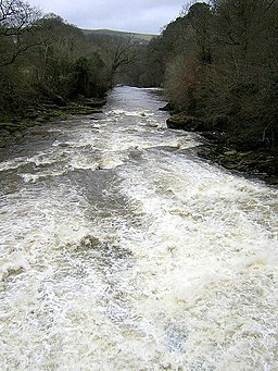
The Corra Linn in full spate, a sight not seen often in the year only when the dam at the power station at Bonnington Linn is open to let the full force of the river spill over the falls.
The Falls of Clyde encompasses a rich tapestry of flora and fauna within its ancient woodlands and along the River Clyde. The reserve is renowned for its spectacular waterfalls—Dundaff Linn, Corra Linn, Bonnington Linn, and Stonebyres Linn—which provide a stunning backdrop to the diverse ecosystems present.
Bonnington Linn, Falls of Clyde. The woodlands are primarily composed of native species such as oak, ash, and birch, creating a varied canopy that supports a multitude of plant life. In spring, the forest floor is adorned with wildflowers, including bluebells, wood anemones, and wild garlic, offering a vibrant display of colors and scents. These floral communities provide essential habitats and food sources for numerous insects and other wildlife.
Sheltered woodland area on the walk. When high winds blow elsewhere, the 6 mile walk round the falls of Clyde can be a haven of calm.
The reserve is a haven for bird enthusiasts, with over 100 species recorded. Visitors may observe dippers and kingfishers along the riverbanks, while the woodlands host species such as ravens and great spotted woodpeckers. The area also supports birds of prey, including peregrine falcons, which can sometimes be seen soaring above the cliffs and gorges.
Mammals are abundant within the reserve. Badgers forage in the undergrowth, and otters are occasionally spotted along the riverbanks, indicating a healthy aquatic ecosystem. In the evenings, Daubenton's bats can be observed feeding over the river, showcasing the reserve's rich biodiversity.
Bonnington Sluice Gates above Falls of Clyde. This weir supplies water to the Falls of Clyde hydro-electric power station.
Beyond its natural wonders, the Falls of Clyde holds historical significance. The area is part of the Clyde Valley Woodlands National Nature Reserve, which preserves remnants of ancient woodlands that once covered much of central Scotland. These woodlands have remained relatively undisturbed for centuries, largely due to the steep gorges that made timber harvesting challenging.
The reserve also features well-maintained walking trails that guide visitors through scenic woodland paths alongside the river, offering breathtaking views of the waterfalls. The New Lanark Visitor Centre, located nearby, provides additional insights into the area's natural and cultural heritage, enhancing the overall visitor experience.
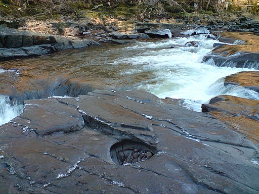
River Clyde. A pothole on a rockshelf on the bed of the River Clyde above Stonebyres Falls. These features are responsible for corrading and thus lowering river beds through vertical erosion.


