Harringworth Welland Viaduct Walk
![]()
![]() This circular walk visits the impressive Harringworth Viaduct or Welland Viaduct in North Northamptonshire.
This circular walk visits the impressive Harringworth Viaduct or Welland Viaduct in North Northamptonshire.
On the way you'll pass the neighbouring village of Seaton and the Seaton Marshes Nature Reserve. The eastern part of the walk includes a section along the long distance Jurassic Way which runs along a particularly lovely area of the River Welland. The northern section around Seaton villages uses part of the Rutland Round, another waymarked trail running through the region.
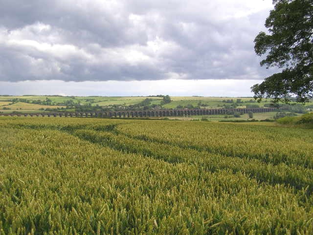
You can start and finish the walk at Harringworth village where there is a decent walker/bike friendly cafe for post walk refreshments. The route then picks up a mixture of public footpaths and country lanes to take you around the photogenic structure. The Grade II listed viaduct is about a kilometre long, and was completed in 1878. It contains 82 arches and is notable as the longest masonry viaduct across a valley in Britain.
On the walk there are also some fine views of the surrounding Welland Valley countryside to enjoy.
Postcode
NN17 3AH - Please note: Postcode may be approximate for some rural locationsHarringworth Welland Viaduct Ordnance Survey Map  - view and print off detailed OS map
Harringworth Welland Viaduct Open Street Map  - view and print off detailed map
Harringworth Welland Viaduct OS Map  - Mobile GPS OS Map with Location tracking
Harringworth Welland Viaduct Open Street Map  - Mobile GPS Map with Location tracking
Pubs/Cafes
Back in Harringworth the Spokes cafe is a nice place for some post walk refreshments. The friendly cafe sells a good range of meals, snacks and treats. There's pleasant outdoor seating and a secure courtyard for bike storage. You can find them at Meadow Cottage with a postcode of NN17 3AH for your sat navs.
Further Information and Other Local Ideas
If you head east along the Jurassic Way you will soon come to Wakerley Woods. There's some great walking and mountain bike trails with lots of deer to look out for in these expansive local woods. Fineshade Woods can also be found in this area.
Just to the east of Fineshade you'll find the pretty village of King's Cliffe where you can pick up the Kings Cliffe Railway Walk. The easy trail runs along a now disused railway line to the east of the village. King's Cliffe is also a pleasant place for a stroll with a Norman church, picturesque 17th century almshouses and nice views of the Willow Brook, a tributary of the River Nene. There's also a fine old 18th century pub for refreshments afterwards. Near here there's also Blatherwycke Lake to explore. There's some lovely waterside trails with lots of birdlife to see on the water at this scenic spot.
Heading west along the Rutland Round will take you to Eyebrook Reservoir where there are some lovely waterside trails to try.
Cycle Routes and Walking Routes Nearby
Photos
Looking southwest down the Welland valley. This view from near Redhill Farm on the B672, just south of Morcott, southwest towards Harringworth and the viaduct.


