Hog's Back Walk
![]()
![]() This walk explores the scenic ridge of the Hog's Back in the North Downs near Guildford in Surrey.
This walk explores the scenic ridge of the Hog's Back in the North Downs near Guildford in Surrey.
The elevated ridge is a great place to enjoy views over the surrounding area. To the north you can see landmarks in the city of London including Canary Wharf, Tower 42, The Gherkin, Wembley Arch and Heathrow Airport. To the south is more rural with views to Hindhead and the Devil's Punch Bowl.
The walk starts a short way south of Guildford train station where you can pick up a country lane heading south west to Henley Fort and the Hog's Back trackway. Follow the ancient track west onto Guildown where there are fine views back down to Guildford. The route then descends to pick up the North Downs Way and follow it west towards Puttenham at the western end of the site. You can then return across Puttenham Heath and Wanborough Common before heading back to Guildford where a final waterside section on the Wey South Path will take you back towards the train station.
Hogs Back Ordnance Survey Map  - view and print off detailed OS map
Hogs Back Open Street Map  - view and print off detailed map
Hogs Back OS Map  - Mobile GPS OS Map with Location tracking
Hogs Back Open Street Map  - Mobile GPS Map with Location tracking
Pubs/Cafes
Just to the south east of the ridge you'll find the pretty village of Shalford next to the river. Here you could visit the Seahorse pub for some well earned refreshment. There's a fine menu and an attractive outdoor space that’s ideal for a spot of al fresco dining when the sun makes a welcomed appearance. You can easily find it in the village at postcode GU4 8BU for your sat navs.
Dog Walking
The bracing ridge walk is a fine one for fit dogs to enjoy. The Seahorse pub mentioned above is also dog friendly.
Further Information and Other Local Ideas
At the western end of the ridge you can extend the walk by visiting Puttenham Common. There's miles of peaceful woodland trails here with a series of pretty ponds. Just to the west of the common you will find the historic Waverley Abbey. There's some nice trails here around the 12th century abbey grounds and along the River Wey. You could also climb to the nearby Crooksbury Hill for more fine views over the Downs.
For more walking ideas in the area see the North Downs Walks page.
Cycle Routes and Walking Routes Nearby
Photos
Hog's Back Trackway. This section of the ancient Harroway is much quieter than that to the west - the thundering A31. The route follows the chalky ridgeline, the drier option compared to the clay valley floors.
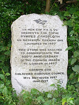
Cornish March Stone. On Guildown at the eastern end of the Hogs Back where there was a skirmish between Cornish and Royalist parties in 1497.


