Long Itchington Walks
![]()
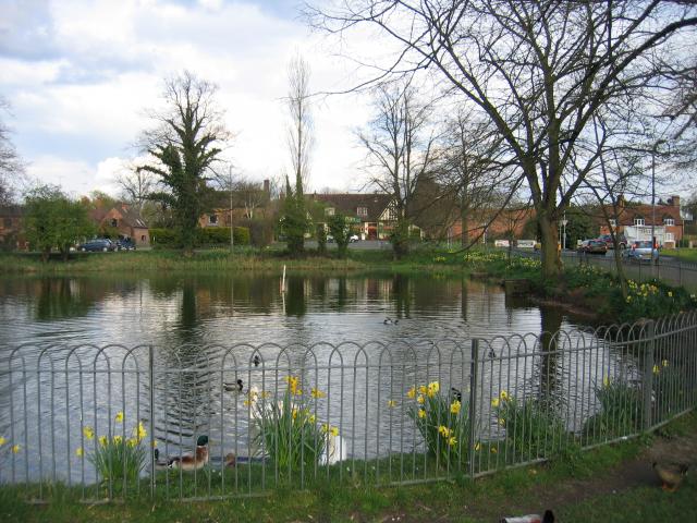
![]() This Warwickshire based village has some nice canal paths and a fine waymarked long distance footpath to try. There's also a few local pockets of woodland and a pretty nature reserve to enjoy. The village itself includes a picturesque green and several historic buildings, including a half-timbered Tudor house at which Queen Elizabeth I is said to have stayed in 1572. There's also the old Manor House in the square which dates from the 15th century.
This Warwickshire based village has some nice canal paths and a fine waymarked long distance footpath to try. There's also a few local pockets of woodland and a pretty nature reserve to enjoy. The village itself includes a picturesque green and several historic buildings, including a half-timbered Tudor house at which Queen Elizabeth I is said to have stayed in 1572. There's also the old Manor House in the square which dates from the 15th century.
This walk from the village follows the Grand Union Canal Walk and the Warwickshire Centenary Way to Ufton Wood and Long Itchington Wood. It's fairly easy walking with the waterside paths and some nice trails around the nature reserve area in Ufton. There is a small climb in Ufton Wood where there's some good views to enjoy from the high points.
The walk starts to the south of the village where you can pick up the canal towpath and follow it west towards Longhole Bridge. The route then turns south along the Centenary Way to visit Ufton and the Ufton Fields Nature Reserve. There's woodland, ponds and lots of widlife to look out for in this area. After exploring the reserve you can pay a visit to the neighbouring Long Itchington Wood, just to the north east. The route then retraces its steps back to the village.
Long Itchington Ordnance Survey Map  - view and print off detailed OS map
Long Itchington Open Street Map  - view and print off detailed map
Long Itchington OS Map  - Mobile GPS OS Map with Location tracking
Long Itchington Open Street Map  - Mobile GPS Map with Location tracking
Walks near Long Itchington
- Grand Union Canal Walk - Follow the towpath of Britain's longest canal from London to Birmingham on this fabulous waterside walk
- Warwickshire Centenary Way - Starting at Kingsbury Water Park (video below) in the north of the county this lovely walk takes you through the River Tame Valley, Atherstone Ridge, Nuneaton, Coombe Abbey Park at Coventry (video below), Kenilworth, Warwick, Leamington Spa, Burton Dassett Hills, Avon Dassett, Edge Hill, Shipston on Stour and Ilmington Downs before finishing at Upper Quinton.
- Southam - The Warwickshire market town of Southam is located in the Stratford-on-Avon district of the county
- Draycote Water - Enjoy a circular waterside cycle or walk around the delightful Draycote Water Country Park near Rugby
- Chesterton Windmill - This walk visits a 17th century windmill neary Harbury in Warwickshire
- Burton Dassett Hills Country Park - This super country park is comprised of a group of ironstone hills which rise to 203m (667 ft)
- Leamington Spa - A figure of eight circuit around the Warwickshire town of Royal Leamington Spa
- Harbury - This pretty village is located close to Southam and Leamington Spa in the county of Warwickshire
- Avon Dassett - This pretty little Warwickshire village is located in a lovely spot on the edge of the Cotswolds
- Farnborough Hall - This National Trust owned site is located in the village of Farnborough in rural Warwickshire.
- Edge Hill - This walk visits Edge Hill from the village of Ratley in Warwickshire
- Napton on the Hill - This Warickshire based village is in a fine location for canal, country and lakeside walking
- Napton Reservoir - This walk visits Napton Reservoir near the village of Napton on the Hill in Warwickshire
Further Information and Other Local Ideas
The Southam Walk is a good way to continue your walking in the area. It also visits Ufton as well as the River Itchen and River Stowe which run through the area. The neighbouring town is well worth exploring too, with its Tudor buildings and 17th century architecture to admire.
For cyclists National Cycle Route 41 runs through the area.
Just to the south you'll find the picturesque village of Harbury where there's a 16th century timber framed pub and a 13th century church to see.
For more walking ideas in the area see the Warwickshire Walks page.
Photos
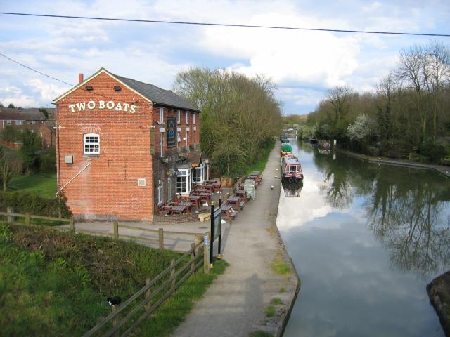
Long Itchington. The Grand Union Canal with the Two Boats public house, seen from the main Coventry - Southam road bridge.
Stockton reservoir anglers. Anglers enjoying an evening's sport at Stockton reservoir (which supplies water to the nearby Grand Union Canal).


