Longtown Cumbria Walks
![]()
![]() This Cumbrian market town is located in the north of the county, very close to the border with Scotland.
This Cumbrian market town is located in the north of the county, very close to the border with Scotland.
The town is notable for the 12th century Arthuret Church and for hosting the largest sheep market in England, on the north side of the River Esk.
This walk takes you south from the town visiting the park by the River Esk before following country lanes and an old railway line to West Linton. On the way you'll cross the River Lyne and enjoy some fine countryside views.
Continuing south will take you into the city of Carlisle where there's lots of interesting history and nice walks along the River Eden.
Longtown Ordnance Survey Map  - view and print off detailed OS map
Longtown Open Street Map  - view and print off detailed map
Longtown OS Map  - Mobile GPS OS Map with Location tracking
Longtown Open Street Map  - Mobile GPS Map with Location tracking
Walks near Longtown
- Carlisle - This circular walk visits the Cumbrian city of Carlisle, exploring the castle grounds before picking up riverisde footpaths on either side of the River Eden
- Hadrian's Wall Path - Starting in Wallsend near the east coast of England, head across the country to Bowness-on-Solway along this wonderful trail that follows the famous Roman wall
- Watchtree Nature Reserve - This super Nature Reserve near Carlisle has a series of cycling and walking trails to try.
- Talkin Tarn Country Park - Explore this 165 acre country park in Brampton, and enjoy the large glacial tarn, mature woodland and gentle meadows with the stunning Pennine Hills as a backdrop
- Brampton - The small market town of Brampton is located in the Carlisle district of Cumbria
- Wetheral - This historic Cumbrian village near Carlisle has some lovely riverside trails, peaceful local woods and the remains of ancient priory to see.
- Wreay Woods - This walk visits the pretty Wreay Woods near Carlisle in Cumbria
- Gelt Woods - Follow the River Gelt through Gelt Woods Nature Reserve, on this delightful walk near Brampton, Cumbria
- Miltonrigg Woods - These delightful woods near Brampton are a lovely place for an afternoon stroll.
- Lanercost Priory - This walk visits the historic Lanercost Priory in Cumbria
- Cumbria Coastal Way - Explore the wonderful coastline of Cumbria on this splendid long distance path
Pubs/Cafes
Back in the town head to the Graham Arms Hotel for some post walk refreshment. The former coaching inn dates back over 250 years and includes a large restaurant, spacious bar and garden area. You can find them on English Street at postcode CA6 5SE for your sat navs.
Further Information and Other Local Ideas
Cycling Information: National Cycle Route 10 and National Cycle Route 7 both run past the town. These signed Sustrans routes are a great way of exploring the area. They mainly use quiet country lanes which are also suitable for walkers.
Photos
Playground beside the River Esk Children's play area and picnic site beside the River Esk at Longtown. The river is in spate after heavy rain. Longtown has a somewhat turbulent history, being very close to the Scottish border. The Border Reivers raided the area for cattle and other goods. Longtown has the largest sheep market in England.
Railway path, Sandysike. This path was constructed in 2000 and follows a short section of the old Waverley line (Carlisle to Edinburgh) which was closed by Beeching.
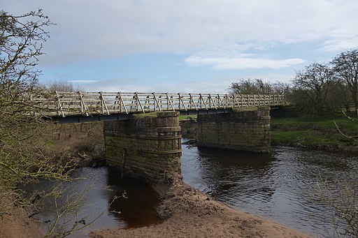
Sandysike Bridge. The stone piers once supported a bridge on the Waverley line (Carlisle to Edinburgh)over the River Lyne. In 2000, a group of Sustrans volunters constructed a light footbridge resting on the piers, thereby providing a safe route for cyclists between Carlisle and Longtown avoiding the busy A7.


