Meltham Walks - Near and Around
![]()
![]() This West Yorkshire based town sits in a nice position on the edge of the Peak District. There's some fine moorland scenery, a series of pretty reservoirs and several local hill climbs to enjoy around the town.
This West Yorkshire based town sits in a nice position on the edge of the Peak District. There's some fine moorland scenery, a series of pretty reservoirs and several local hill climbs to enjoy around the town.
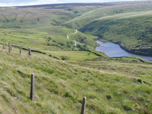
This circular walk from the town explores the moorland to the west of the settlement. On the way you'll visit Meltham Moor, Wessenden Reservoir, Butterley Reservoir and Deer Hill Reservoir.
The walk starts in the village and follows country lanes west and then south to visit Meltham Moor. You'll climb to Milston Hill before coming to West Nab which stands at a height of 500 metres. There's great views and some interesting rock formations to see here.
The route continues west past Holly Bank Moss to link up with the Pennine Way at Leyzing Clough. Follow the waymarked trail north west and it will take you past Great Hey Cote Hill to Wessenden Reservoir and Blakeley Reservoir. There's some waterfalls and views of the Wessenden Brook in this area.
The route then heads north along Blakeley Reservoir to Butterley Reservoir. You then head past Binn Moor and Holme Moss to Deer Hill Reservoir. From here paths take you south east back towards Meltham.
Meltham Ordnance Survey Map  - view and print off detailed OS map
Meltham Open Street Map  - view and print off detailed map
Meltham OS Map  - Mobile GPS OS Map with Location tracking
Meltham Open Street Map  - Mobile GPS Map with Location tracking
Walks near Meltham
- Butterley Reservoir - This walk uses part of the Kirklees Way to visit three pretty reservoirs on the splendid Marsden Moor Estate in the Peak District.
The walk starts from the large village of Marsden near Huddersfield - Kirklees Way - Explore the Kirklees metropolitan district on this challenging circular walk through West Yorkshire
- Pennine Way - This fabulous 268 mile path takes you through three of England's finest national parks
- Marsden Moor - This circular walk explores the wonderful Marsden Moor Estate in the Pennines
- Standedge Trail - A lovely circular walk through Kirklees visiting the Standedge Tunnels
- Holmfirth - This circular walk explores the immediate area surrounding the town of Holmfirth in Yorkshire
- Digley Reservoir - Enjoy an easy circular walk around this delightful reservoir near Holmfirth in the Yorkshire Dales
- Wessenden Reservoir - This walk visits Wessenden Reservoir and Moor in West Yorkshire
- Folly Dolly Falls - This walk visits the pretty Folly Dolly Falls in Meltham in Yorkshire
- Blackmoorfoot Reservoir - This short walk visits Blackmoorfoot Reservoir in Huddersfield
- Deer Hill Reservoir - This small reservoir is located near Meltham and Huddersfield in Kirklees.
- Holme Styes Reservoir - This walk visits the pretty Holme Styes Reservoir near Holmfirth in Yorkshire
- Meltham Mills Reservoir - This walk visits the Meltham Mills Reservoir in Meltham in West Yorkshire.
- Brownhill Reservoir - This walk visits Brownhill Reservoir near Holmfirth.
- Ramsden Reservoir - This walk visits Ramsden Reservoir near the Yorkshire town of Holmfirth
Pubs/Cafes
Back in the town head to the Travellers Rest for some post walk refreshment. The pub has a friendly atmosphere and is a popular place for walkers. They have a lovely large garden area where you can enjoy great views with your meal. You can find them on Slaithwaite Rd with a postcode of HD9 5NH for your sat navs.
Dog Walking
The moorland trails and hill climbs are great for fit dogs. The Travellers Rest mentioned above is also dog friendly.
Further Information and Other Local Ideas
On the eastern side of the town you can follow the Meltham Greenway to the delightful Folly Dolly Falls. The cascade is a bit of hidden gem and well worth a visit after heavy rain. Just south of here there's also Honley Woods and Meltham Mills Reservoir where there's some peaceful woodland trails around the small lake.
To the west of the town you can pick up the circular Marsden Moor Walk and explore this expansive area of moorland. In this area you can also pick up the Standedge Trail and take in the interesting Standedge Tunnels.
Just to the south east is the popular town of Holmfirth where you can visit Digley Reservoir, Brownhill Reservoir and Ramsden Reservoir.
For more walking ideas in the area see the South Pennines Walks and Peak District Walks pages.
Photos
Bellman Castle, Meltham Moor. One of the few rock formations up here named on the OS maps. This name goes back to the 1850 six-inch map.


