Watendlath Tarn Walk
![]()
![]() This is a lovely waterside walk to the delightful Watendlath Tarn near Derwent Water, Keswick.
This is a lovely waterside walk to the delightful Watendlath Tarn near Derwent Water, Keswick.
The walk starts at the Suprise View car park towards the southern end of the lake. This splendid viewpoint looks out over Derwent Water, Keswick, and beyond to Bassenthwaite Lake.
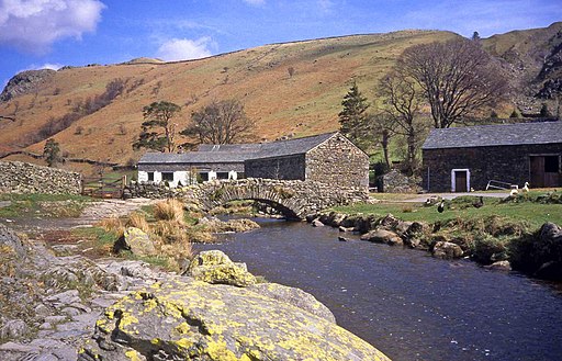
You then follow woodland trails through Ashness Wood to Watendlath Beck where you pick up a super waterside trail which leads to the tarn. The pretty hamlet of Watendlath has an old packhorse bridge, and a National Trust tea-room, where you can sit outside and enjoy the wonderful views.
An alternative route is to walk up to the tarn from nearby Rosthwaite. It is situated about a mile south west of the tarn, with a good track leading directly up to Watendlath. See our Circular Walk from Rosthwaite for full details of this route. The walk also visits the pretty Dock Tarn to the south and includes a waterside path along the photogenic Stonethwaite Beck.
If you have time you could extend your walk by visiting the beautiful Lodore Falls.
Watendlath Tarn Ordnance Survey Map  - view and print off detailed OS map
Watendlath Tarn Open Street Map  - view and print off detailed map
Watendlath Tarn OS Map  - Mobile GPS OS Map with Location tracking
Watendlath Tarn Open Street Map  - Mobile GPS Map with Location tracking
Pubs/Cafes
Next to the tarn in the little hamlet there's the Caffle House Tearooms. You can enjoy a delicious home made cream tea here. There is also a car park if you would prefer to start the walk from here.
Near the start of the route there's the Mary Mount Hotel. They have a restaurant with a lovely terrace where you can sit outside and enjoy views of the surrounding fells. In addition to the full menu and specials board they serve sandwiches, baguettes and wraps at lunch. You can find them just north of the falls at postcode CA12 5UU for your sat navs.
The Lodore Falls Hotel is also very close by and also has a fine restaurant area.
Cycle Routes and Walking Routes Nearby
Photos
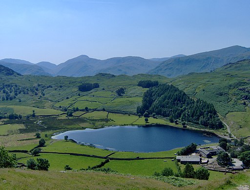
This view of the hamlet and tarn opens up on the path from Thirlmere where the hillside becomes steeper.
This picturesque spot is right at the end of the minor road at Watendlath. The view is looking south over the tarn.


