Whalley Abbey and River Calder Viaduct Walk
![]()
![]() Visit the fascinating remains of this former Cistercian abbey and enjoy a waterside stroll along the Calder River on this lovely circular walk in the Lancashie village of Whalley.
Visit the fascinating remains of this former Cistercian abbey and enjoy a waterside stroll along the Calder River on this lovely circular walk in the Lancashie village of Whalley.
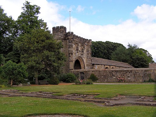
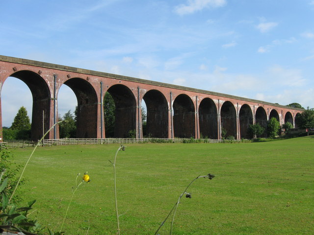
As well as the atmospheric ruins there are delightful grounds and gardens to enjoy. There is also a fine 14th century gatehouse in excellent condition. Just to the west there's also the impressive Whalley Viaduct. Also known as "Whalley Arches" the 19th century structure is noteworthy as the longest and largest railway viaduct in Lancashire.
The abbey is located by the River Calder so you can extend your walk by heading along the water to the nearby Spring Wood which used to be owned by the abbey monks. Here you will find a splendid nature trail, ancient woodland, ponds, bluebells and wildflowers.
Just to the west you will find the interesting village of Ribchester. There's the remains of an old Roman Fort and nice waterside trails along the River Ribble to be found here.
The town of Clitheroe is just to the north. The splendid castle and grounds are well worth a visit.
If you are coming by train then the abbey is just a short walk from Whalley Railway Station.
Postcode
BB7 9SS - Please note: Postcode may be approximate for some rural locationsPlease click here for more information
Whalley Abbey and the River Calder Ordnance Survey Map  - view and print off detailed OS map
Whalley Abbey and the River Calder Open Street Map  - view and print off detailed map
Whalley Abbey and the River Calder OS Map  - Mobile GPS OS Map with Location tracking
Whalley Abbey and the River Calder Open Street Map  - Mobile GPS Map with Location tracking
Pubs/Cafes
The Dog Inn is a nice place for refreshments after your walk. The friendly village pub serves good food and has a nice garden area as well. You can find them at 55 King St, BB7 9SP.
Further Information and Other Local Ideas
For a longer circular walk in the area try the Whalley Nab Walk. This heads south to visit the nearby hill before exploring the surrounding countryside and the Spring Wood Nature Reserve.
Just to the north is the pretty village of Sawley. Here you can visit the ruins of the 12th century Sawley Abbey which is run by English Heritage. The river is particularly scenic here and there's also a splendid riverside pub for post walk refreshments. Just west of here is the neighbouring village of Waddington. The village is very pretty and a regular winner of the Lancashire Best Kept Village awards. A stroll along the Waddington Brook and through the delightful Coronation gardens is recommended here. To the east is Gisburn with its fine 18th century coaching inn and views of the Stock Beck.
Also in this area is the worthy village of Bolton by Bowland where there's two pretty village greens and views of the Skirden Beck.
For more walking ideas in the area see the Ribble Valley Walks and Lancashire Walks pages.
Cycle Routes and Walking Routes Nearby
Photos
View of the which are a Grade I listed building and a Scheduled Ancient Monument. The site of the abbey was first consecrated in 1306 after the Cistercian monks from Stanlow Abbey had moved to Whalley. The church was completed in 1380 but the remainder of the abbey was not finished until the 1440s.
The abbey closed in 1537 as part of Henry VIII's dissolution of the monasteries. Following which, the abbey was largely demolished and a country house was built on the site. In the 20th century the house was modified and it is now the Retreat and Conference House of the Diocese of Blackburn. Today, only the foundations remain of the church. The remains of the former monastic buildings are more extensive.
Whalley Viaduct. The photogenic structure carries the Ribble Valley Line over the river Calder for approximately 620m.


