Afan Forest Park Walks and Mtb
![]()
![]() Set in the beautiful Afan Valley in Neath Port Talbot, this 48-square-mile forest park has miles of cycling trails, walking trails and several fantastic mountain bike trails.
Set in the beautiful Afan Valley in Neath Port Talbot, this 48-square-mile forest park has miles of cycling trails, walking trails and several fantastic mountain bike trails.
For a nice easy cycle the Rheilffordd Trail is a great option. It takes you along the River Afan on a disused railway path.
For mountain bikers there are several well laid out trails. The Penhydd Trail is a 22km loop voted as the trail to ride before you die by What Mountain Bike Magazine in 2004. The 46km Skyline Trail has stunning skyline views of the Brecon Beacons, the Preselis, the Black Mountains and the South Wales coast.
Walkers will find 14 waymarked circular trails taking you along the River Afan, through the peaceful woodland and up to the Ridgetops where there are fabulous views to enjoy.
If you have time you could continue your outing by heading a couple of miles north east to the nearby Glyncorrwg Ponds where you will find lovely waterside walking and cycling trails.
Postcode
SA13 3HG - Please note: Postcode may be approximate for some rural locationsPlease click here for more information
Afan Forest Park Country Park Ordnance Survey Map  - view and print off detailed OS map
Afan Forest Park Country Park Open Street Map  - view and print off detailed map
*New* - Walks and Cycle Routes Near Me Map - Waymarked Routes and Mountain Bike Trails>>
Afan Forest Park Country Park OS Map  - Mobile GPS OS Map with Location tracking
Afan Forest Park Country Park Open Street Map  - Mobile GPS Map with Location tracking
Pubs/Cafes
Back at the main car park there's the on site cafe for some refreshments after your exercise. They sell a good range of meals and snacks with some particularly delicious cakes.
Dog Walking
As you'd expect the forest trails at the park are ideal for dog walking. You'll probably bump into other owners on a fine day.
Further Information and Other Local Ideas
The St Illtyd's Walk and the Coed Morgannwg Way both run through the park. These waymarked long distance trails provide an opportunity for exploring the surrounding area on foot. One nice idea is to follow the trails south and visit the lovely Margam Country Park. The park is great for walkers with features including the historic Margam Castle, an 18th Century Orangery with ornamental gardens and a Deer Park, all set within 1000 acres of beautiful countryside. For cyclists there are lots of trails too with a section of the National Cycle Network known as the Celtic Trail Route 4 running through the park. Just north of the parh there's the unusual Brombil Reservoir. The picturesque turquiose coloured lake is a lovely place for a peaceful stroll. From the hills surrounding the lake there are fine views to the coast too.
Head north from the park and you can find more walking trails in the wonderful Brecon Beacons and the Black Mountains.
Cycle Routes and Walking Routes Nearby
Photos
Cycle track in the park. This track follows the route of the former 'Rhondda & Swansea Bay Railway'. In the distance under the bridge is the platform of Cynonville Halt.
A clearing at Afan Forest Park. A clearing with a view towards the steep, forested slopes on the north side of the Afan Valley (Cwm Afan) near Cynonville. The photograph was taken at a point close to grid square boundaries. Some of the more distant parts of the clearing seen lie in square SS8293, whereas the section of forestry edge visible at the far side of the clearing lies in SS8294.
Section of the Granada bike trail. The forest is now one of the premier Mountain Bike riding venues in the whole of the UK.
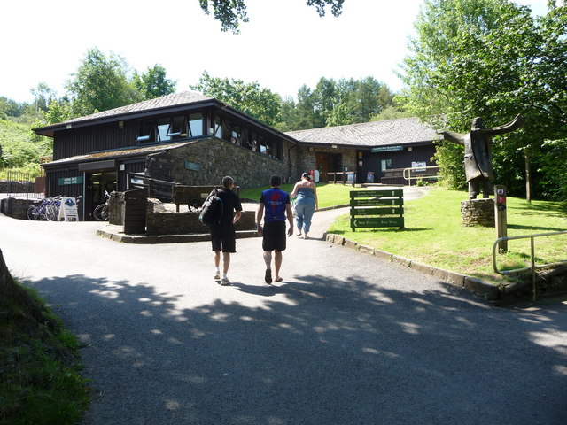
Afan Forest Park Visitor Centre. The Centre includes camping facilities with a shower block and toilet block which can also be used by other visitors. There's also a cafe, small local museum on mining, bike shop, education facilities and a gift shop.
Forestry on the southern slopes of Mynydd Penhydd and Pen Disgwylfa. A view from a track on Mynydd Penhydd showing conifers at the southern edge of Afan Argoed Forest Park. The partly-cleared hill whose top is seen in the upper left of the picture is Pen Disgwylfa. It lies chiefly in grid square SS8293.
Landscape to the west of Maesteg. A view from Foel Trawsnant in the direction of Maesteg over a landscape dominated by forestry. The small hill seen in the centre of the picture is Moel Bryn-mawr which lies at the western edge of Maesteg in grid square SS8491 and has a television relay station on top. Much of the green, open land seen to the right of, and in front of, the hill lies on a golf course.


