Ballycastle Fair Head Walk
![]() This circular walk visits the wonderful cliff tops at Fair Head near Ballycastle in County Antrim.
This circular walk visits the wonderful cliff tops at Fair Head near Ballycastle in County Antrim.
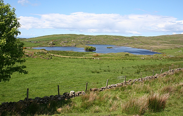
You can start the walk from the car park at the farm, just to the south of the headland. Head north and the footpaths will take you past Lough na Cranagh to the cliff tops where you can enjoy great views out to Rathlin Island. You can then loop round on the country lanes to return to the car park.
If you head east along the coast you could also visit Torr Head. The scenic area is notable as the closest point in Northern Ireland to Scotland, with only 12 miles separating them across the Irish Sea.
To continue your walking in the area head south east to visit Ballypatrick Forest. There's miles of peaceful woodland trails, a series of small ponds and nice views of the Glenmakeeran River here. To the west there's the historic Kinbane Castle and the Causeway Coast's Carrick-a-Rede where there's more cliff top paths and views to the Scottish Islands.
Please scroll down for the full list of walks near and around Ballycastle. The detailed maps below also show a range of footpaths, bridleways and cycle paths in the area.
Ballycastle Fair Head Walk Open Street Map  - view and print off detailed map
Ballycastle Fair Head Walk Open Street Map  - Mobile GPS Map with Location tracking
Walks near Ballycastle
- Ballypatrick Forest - This large forest in Northern Ireland has miles of footpaths to try
- Glenariff Forest Park - This 1185 hectare (2928 acre) forest has miles of walking trails including the waterfall walk and scenic trail.
The waterfall walk is particularly lovely with footpaths leading you through steep wooded gorges with a series of beautiful falls to enjoy - Carrick-a-Rede - This popular coastal walk crosses the famous rope bridge to visit Carrick-a-Rede Island on Northern Ireland's Causeway Coast.
You can start the walk from the car park, just to the north east of Ballintoy - Giant's Causeway - This spectacular coastal causeway in Northern Ireland has a unique polygonal landscape feature.
- Causeway Coast - Follow National Cycle Network Route 93 along the North Atlantic coast on this exhilarating cycle route in Northern Ireland
- Mussenden Temple - This circular walk visits the precariously positioned Mussenden Temple in Castlerock, County Londonderry.
- Portballintrae to Ballintoy Coastal Walk - This coastal walk takes you along the spectacular Causeway coast from Portballintrae to Ballintoy via Dunseverick.
- Portrush to Portstewart Cliff Walk - This popular coastal walk follows a section of the Causeway Coast from Portrush to Portstewart.
- Rathlin Island - This walk explores the RSPB Roonivoolin Reserve on Rathlin Island off the coast of County Antrim.
- Torr Head - This walk visits Torr Head on the beautiful County Antrim coast near Ballycastle.
Further Information and Other Local Ideas
In Ballycastle you can catch the ferry to the beautiful Rathlin Island. There are some splendid trails here with lots of wildlife to see in the RSPB nature reserve on the island.
Photos
Fair Head boasts a sheer and vertical dolerite rock face towering 100 metres (330 ft) high, characterised by distinctive vertical columns resembling organ pipes. These formations were created approximately 60 million years ago when a sill of igneous rock was injected between horizontal Carboniferous sediments. Renowned as one of the premier traditional climbing and bouldering destinations in the British Isles and Ireland, Fair Head offers extensive opportunities for climbers. It ranks among the largest expanses of climbable rock in Northwest Europe and features a vast array of extreme-graded routes, making it a sought-after destination for climbers and adventurers alike.
There is a rough path through this wilderness of boulder scree to the bottom of the Grey Man's Path, a steep scramble to the top of Fair Head, and to Murlough Bay beyond.
Fair Head's headland towers 200 metres (660 ft) above the sea, stretching for more than 5 kilometres (3.1 mi). The dolerite rock formations rise over 100 metres (330 ft) high at certain points along the coast. Below the cliff's edge, wild goats roam among the rocks, while The Grey Man's Path, a scenic walkway, winds its way along the rugged coastline.


