Bardon Mill Walks
![]()
![]() This Northumberland based village is close to several county highlights including Hadrian's Wall and the Housesteads Roman Fort. There's also a noteworthy pottery and good views of the River South Tyne which passes through the village.
This Northumberland based village is close to several county highlights including Hadrian's Wall and the Housesteads Roman Fort. There's also a noteworthy pottery and good views of the River South Tyne which passes through the village.
This walk from the village visits the splendid Allen Banks and Staward Gorge. You can follow country lanes south east from the village, crossing the River South Tyne and passing Beltingham before arriving at the gorge. The National Trust owned site includes lovely woodland trails taking you along the River Allen to Plankey Mill.
Postcode
NE47 7HU - Please note: Postcode may be approximate for some rural locationsBardon Mill Ordnance Survey Map  - view and print off detailed OS map
Bardon Mill Open Street Map  - view and print off detailed map
Bardon Mill OS Map  - Mobile GPS OS Map with Location tracking
Bardon Mill Open Street Map  - Mobile GPS Map with Location tracking
Walks near Bardon Mill
- Haydon Bridge - This Northumberland based village has some nice river and country trails to try
- Allen Banks and Staward Gorge - Enjoy a waterside walk along the River Allen and through a beautiful wooded gorge on this easy walk in the North Pennines AONB
- Plankey Mill - This walk visits Plankey Mill near Hexham
- Hexham - This walk takes you along the Weardale Way long distance trail from Hexham to Chester's Roman Fort on Hadrian's Wall
- Housesteads - Visit the fascinating Housesteads Roman Fort on this circular walk around Hadrian's Wall in the Northumberland National Park
- Allendale - The village of Allendale is located in a lovely spot by the River East Allen in the North Pennines Area of Outstanding Natural Beauty
- Isaac's Tea Trail - Follow in the footsteps of the legendary tea seller Isaac Holden on this challenging circular walk through the North Pennines.
The walk starts at the pretty village of Allendale Town, and heads south along the River East Allen and through West Allen Dale to Nenthead, where you will find the interesting Nenthead Mining Centre - Alston - This Cumbrian market town is located in a lovely spot on the River South Tyne
- Greenlee Lough - This walk visits the pretty Greenlee Lough Nature Reserve from Hadrian's Wall
- Pennine Way - This fabulous 268 mile path takes you through three of England's finest national parks
- Sycamore Gap - Sycamore Gap was voted England's tree of the year in 2016
- Birdoswald - This circular walk explores the fascinating Birdoswald Roman Fort on the Cumbrian section of Hadrian's Wall
- Steel Rigg Circular Walk - This circular walk explores the area to the east of the Steel Rigg car park on Hadrian's Wall
- Crammel Linn Waterfall Walk - This walk visits the lovely Crammel Linn waterfall near Gilsland on the border between Cumbria and Northumberland
- Lanercost Priory - This walk visits the historic Lanercost Priory in Cumbria
Pubs/Cafes
Back in the village head to The Bowes Hotel for some post walk refreshments. They serve a fine Sunday lunch and can be found in the village centre close to the train station.
Dog Walking
The country and woodland trails make for a fine dog walk. The Bowes mentioned above is also dog friendly.
Further Information and Other Local Ideas
Head north from the village and you can visit the Vindolanda Roman Fort before coming to Hadrian's Wall Path. In this area you can visit Housesteads, Greenlee Lough and Sycamore Gap.
For more walking ideas in the area see the Northumberland Walks and North Pennines Walks pages.
Photos
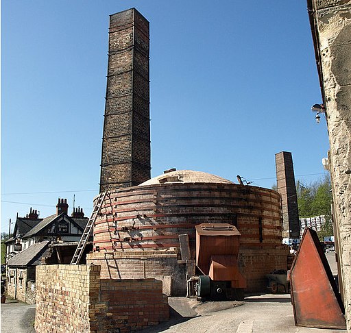
Bardon Mill Pottery. The pie kiln and chimneys with The Bowes Hotel in the background. The only commercial pottery in the United Kingdom currently licensed to produce salt glaze pottery is Errington Reay & Co., which was established in the village in 1878.


