Barnack Hills And Holes
![]()
![]() This walk explores the unique landscape of the Barnack Hills and Holes National Nature Reserve in the Cambridgeshire village of Barnack.
This walk explores the unique landscape of the Barnack Hills and Holes National Nature Reserve in the Cambridgeshire village of Barnack.
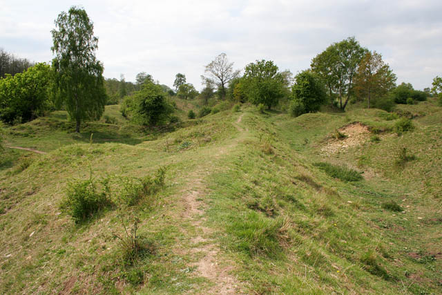
The 50 acre site includes some pleasant footpaths taking you around the grassy slopes of the ancient medieval quarry. It's a significant site for flora and fauna with wildflowers, orchids, limestone grassland and a wide variety of insects.
You'll find the site on the western side of Barnack village. There is a public car park where you can pick up the trails.
If you felt like extending the walk then you could pick up the Torpel Way on the eastern side of the village. The long distance trail could be followed through the countryside to nearby Stamford.
On the western side there's the Hereward Way which could be followed to Burghley House with its lovely parkland and large lake.
Postcode
PE9 3EU - Please note: Postcode may be approximate for some rural locationsBarnack Hills And Holes Ordnance Survey Map  - view and print off detailed OS map
Barnack Hills And Holes Open Street Map  - view and print off detailed map
Barnack Hills And Holes OS Map  - Mobile GPS OS Map with Location tracking
Barnack Hills And Holes Open Street Map  - Mobile GPS Map with Location tracking
Walks near Barnack
- Stamford - The Lincolnshire town of Stamford has a number of good options for walkers visiting the area
- Burghley House - Explore the stunning grounds surrounding this grand 16th-century country house in Stamford, Lincolnshire
- Peterborough - There's lots of fairly easy walks to enjoy around the cathedral city of Peterborough
- Rockingham Forest - A lovely walk from King's Cliffe to Barrowden through the ancient woodland of Rockingham Forest.
The walk starts in the village of King's Cliffe and picks up a section of the Jurassic Way long distance trail to take you through Westhay Woods in Fineshade Woods - Rutland Water - This splendid Nature Reserve has a fabulous cycling and walking path around the perimeter of the huge artificial lake
- Exton - This Rutland based village has some pleasant trails to follow through the parkland of the historic Exton Hall
- Harringworth Welland Viaduct - This circular walk visits the impressive Harringworth Viaduct or Welland Viaduct in North Northamptonshire.
- Kings Cliffe Railway Walk - This walk takes you along the old disused railway line in the Northamptonshire village of King's Cliffe.
- Blatherwycke Lake - This walk visits the little Northamptonshire village of Blatherwycke where you can enjoy a stroll along the pretty lake
- Empingham - This Rutland based village sits very close to the Rutland Water dam with its waterside walking and cycling routes.
- Clipsham - This walk explores the lovely Yew Tree Avenue in the Rutland village of Clipsham.
- Torpel Way - This walk runs from Peterborough to Stamford through countryside and agricultural land
- Hereward Way - Starting in Oakham, in Rutland, follow the Herward Way through Stamford, Peterborough, Ely, and the Breckland forests to Thetford, in Norfolk
- Castor Hanglands - Explore the woodland, limestone, wetland grassland and scrub in this large National Nature Reserve near Peterborough
Pubs/Cafes
In the village you could head to the Millstone for some refreshments after your walk. It's an historic pub of some note, dating to 1672. They have bistro dining and a beautiful courtyard with it’s own outside bar. You can find them close to the reserve at a postcode of PE9 3ET for your sat navs.
Dog Walking
The site is great for dog walking and they can be off leads too. The Millstone pub mentioned above is also dog friendly.
Photos
Formed by the rubble of a Roman and mediaeval quarry, Barnack Hills and Holes is one of Britain’s most important and unusual wildlife sites. Half the surviving limestone grassland in Cambridgeshire is found at the site, which is a Special Area for Conservation (SAC), to protect the orchid rich grassland. It is managed by English Nature.


