Beaconsfield Circular Walk
![]()
![]() This circular walk from Beaconsfield explores some lovely Chilterns countryside. You'll also visit the lovely Hodgemoor Woods and the interesting village of Chalfont St Giles. The 11 mile route uses a mixture of public footpaths, country lanes and a section of the South Bucks Way.
This circular walk from Beaconsfield explores some lovely Chilterns countryside. You'll also visit the lovely Hodgemoor Woods and the interesting village of Chalfont St Giles. The 11 mile route uses a mixture of public footpaths, country lanes and a section of the South Bucks Way.
The walk starts from the train station and heads north through the town to Brown's Wood near Knotty Green You then turn east to Owlsears Wood before coming to Hodgemoor. The 250 acre woods include lots of pretty bluebells in the spring and a healthy population of Muntjac Deer to look out for. Also keep your eyes peeled for tawny owls, buzzards, kites and numerous other woodland birds.
After leaving the woods you come to Chalfont St Giles. The attractive village includes nice cottages with a duck pond fed by the River Misbourne. Other highlights include the church of Saint Giles which is of Norman architecture and dates from the 12th century. You can also visit the former home of John Milton, author of the epic poem 'Paradise Lost'. The house is now a open to the public as a museum and includes an extensive collection of 17th-century first editions of John Milton's works, both poetry and prose. There's a good selection of pubs and cafes so it makes an ideal stopping point for refreshments, at what is about the half way point of the walk.
From the village you pick up the waymarked South Bucks Way long distance footpath. Follow it south and it takes you past Dibden Hill toward Chalfont St Peter.
Here you turn west to follow paths through Jordans and Seer Green, where you pass the golf course before returning to Beaconsfield.
To continue your walking around the Beaconsifield area you could pick up the Chiltern Way and the Chiltern Heritage Trail at Hodgemoor Woods. You could also visit the popular town of Amersham and try our Amersham Circular Walk.
Postcode
HP9 2JH - Please note: Postcode may be approximate for some rural locationsBeaconsfield Ordnance Survey Map  - view and print off detailed OS map
Beaconsfield Open Street Map  - view and print off detailed map
*New* - Walks and Cycle Routes Near Me Map - Waymarked Routes and Mountain Bike Trails>>
Beaconsfield OS Map  - Mobile GPS OS Map with Location tracking
Beaconsfield Open Street Map  - Mobile GPS Map with Location tracking
Walks near Beaconsfield
- Hodgemoor Woods - These woods near the town of Amersham have some good footpaths and mountain bike trails to try.
You can start off at the car park on Bottrells Lane at the northern edge of the site - Amersham Circular Walk - This circular walk around the market town of Amersham visits the nearby village of Chalfont St Giles while exploring the attractive countryside of the Misbourne valley
- Gerrards Cross - This Buckinghamshire based town is in a nice location for exploring the Chiltern Hill AONB
- Penn Wood - This walk visits Penn Wood near High Wycombe and Amersham in Buckinghamshire.
- Little Missenden - This delightul Buckinghamshire village has some nice country and river walking trails to try
- Chalfont St Giles - This pretty Buckinghamshire village sits in a nice rural spot on the edge of the Chilterns AONB.
- Black Park Country Park - With over 10 miles of well signed cycling and walking tracks, Black Park is the ideal place for a great day out in the country
- Langley Park Country Park - Langley Park has a variety of beautiful trails suitable for cycling and walking
- Sarratt - This picture postcard village sits in a delightful spot in the Chess Valley in Hertfordshire
- South Bucks Way - The South Bucks Way runs from Coombe Hill near Wendover to Denham near Uxbridge for a distance of approximately 23 miles
- Chiltern Heritage Trail - Travel through the Chilterns Hills on this splendid circular walk and visit numerous delightful hamlets, villages and towns in Buckinghamshire
- Chiltern Way - This is the original 125 mile circuit of the Chilterns AONB taking you through Hemel Hempstead, Chalfont St Giles, Marlow, Hambleden, Turville, Fingest, Bix Bottom, Ewelme, the Ridgeway, Stokenchurch, Great Hampden, Aldbury, the Dunstable Downs Country Park, Sharpenhoe Clappers and Harpenden
- Seer Green - This Buckinghamshire village is located in a pleasant rural spot in the Chilterns, just to the east of Beaconsfield.
- Wooburn Green - This pretty village is located near High Wycombe and Beaconsfield in Buckinghamshire.
Pubs/Cafes
The Royal Saracens Head dates from the 18th century and serves good quality food. You can find them at postcode HP9 2JH. They are also dog friendly.
Further Information and Other Local Ideas
To the east of the town you'll find Gerrards Cross where there's some nice trails on the town's common and a notable 17th century commonside pub to visit afterwards.
Just to the south there's the neighbouring village of Wooburn Green. There's a pleasant large green here with a number of historic properties including a 16th century public house. There's also a pretty local park with walks along the River Wye and peaceful adjacent woodland.
For more walking ideas in the area see the Chilterns Walks and the Buckinghamshire Walks pages.
Photos
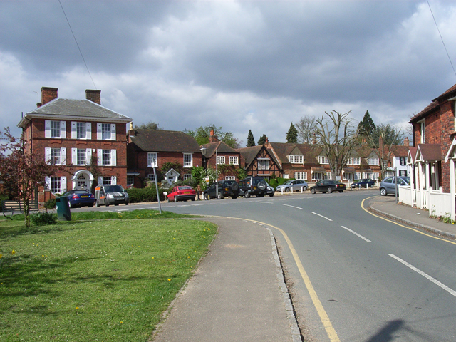
The Royal Saracens Head, Beaconsfield. Old Beaconsfield has a number of old coaching inns along a wide street of red brick houses and small shops. The town was the first stopping point on the road between London and Oxford, as it is equidistant between the two cities.


