Chalfont St Peter Walks
![]()
![]() This Buckinghamshire based village has some nice trails through the Colne Valley and into the surrounding Chiltern Hills.
This Buckinghamshire based village has some nice trails through the Colne Valley and into the surrounding Chiltern Hills.
The village is part of the 'Chalfonts' along with Chalfont St Giles and Little Chalfont.
This circular walk from the village visits some of the highlights to the east including the lakes and rivers of the Colne Valley and the Grand Union Canal. There's some attractive farmland and nice waterside sections to enjoy on the route.
The walk starts in the village centre where you can pick up the South Bucks Way. Follow the waymarked footpath east and then south and it will take you past Hogtrough Wood. The trail continues east along the Old Shire Lane Circular Walk before reaching the lakes of the Colne Valley at West Hyde House. The route then heads north to Pynesfield Lake where you can cross to join up with the Grand Union Canal and the Colne Valley Trail. The route then heads back to Chalfont St Peter on alternative footpaths and country lanes.
Chalfont St Peter Ordnance Survey Map  - view and print off detailed OS map
Chalfont St Peter Open Street Map  - view and print off detailed map
Chalfont St Peter OS Map  - Mobile GPS OS Map with Location tracking
Chalfont St Peter Open Street Map  - Mobile GPS Map with Location tracking
Walks near Chalfont St Peter
- Amersham Circular Walk - This circular walk around the market town of Amersham visits the nearby village of Chalfont St Giles while exploring the attractive countryside of the Misbourne valley
- Chiltern Heritage Trail - Travel through the Chilterns Hills on this splendid circular walk and visit numerous delightful hamlets, villages and towns in Buckinghamshire
- Beaconsfield - This circular walk from Beaconsfield explores some lovely Chilterns countryside
- Hodgemoor Woods - These woods near the town of Amersham have some good footpaths and mountain bike trails to try.
You can start off at the car park on Bottrells Lane at the northern edge of the site - Chiltern Way - This is the original 125 mile circuit of the Chilterns AONB taking you through Hemel Hempstead, Chalfont St Giles, Marlow, Hambleden, Turville, Fingest, Bix Bottom, Ewelme, the Ridgeway, Stokenchurch, Great Hampden, Aldbury, the Dunstable Downs Country Park, Sharpenhoe Clappers and Harpenden
- Sarratt - This picture postcard village sits in a delightful spot in the Chess Valley in Hertfordshire
- Colne Valley Trail - Follow the Colne Valley Trail from Uxbridge to Rickmansworth and enjoy riverside and canalside walking or cycling.
The trails follows the Grand Union Canal and the River Colne while also passing a series of pretty Lakes including Lynsters, Stocker's and Batchworth Lake - Black Park Country Park - With over 10 miles of well signed cycling and walking tracks, Black Park is the ideal place for a great day out in the country
- Gerrards Cross - This Buckinghamshire based town is in a nice location for exploring the Chiltern Hill AONB
- Chalfont St Giles - This pretty Buckinghamshire village sits in a nice rural spot on the edge of the Chilterns AONB.
- Little Chalfont - This attractive Buckinghamshire village is part of the 'Chalfonts' along with Chalfont St Giles and Chalfont St Peter.
- Langley Park Country Park - Langley Park has a variety of beautiful trails suitable for cycling and walking
Further Information and Other Local Ideas
Just to the south is the neighbouring town of Gerrards Cross where there's some nice trails on the town's common and a notable 17th century commonside pub to visit afterwards.
Near the village you will find a historic highlight of the area at the Chiltern Open Air Museum. The museum rescues and restores common English buildings from the Chilterns and relocates them to its 45-acre site, which includes woodland and parkland walking trails.
Just to the north west you'll find the sister village of Chalfont St Giles, part of the three Chalfonts. It's another attractive village notable as the former residence of John Milton, author of the epic poem 'Paradise Lost'. The cottage is now open as a museum and one of the literary highlights of the area.
For more walking ideas in the area see the Chilterns Walks and the Buckinghamshire Walks pages.
Photos
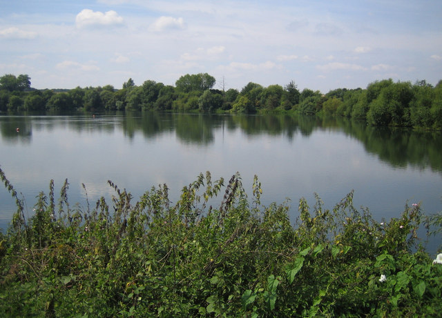
West Hyde. The lake is a former gravel pit in the valley of the River Colne, now flooded and used for recreational purposes, such as sailing, fishing, and wildlife observation. A look at the 1940s Ordnance Survey map shows the land in the valley is undisturbed, so the gravel pits must have been excavated after the Second World War.
Grand Union Canal above Black Jack's Lock, Harefield
Chalfont St. Peter: Bloom Wood. There are numerous old pit workings in Bloom Wood, presumably for flints, and this is one, with the ground covered in beech leaves.


