Brighton Way
54.1 miles (87 km)
![]()
![]() A super route though the South Downs from Horley to Brighton. The trail passes Crawley, Haywards Heath and Burgess Hill before finishing on the south coast. The walk has several train stations dotted along the route so you can easily do this one in manageable sections. Highlights include the Ardingly Nature Reserve and Ardingly Reservoir near Balcombe. Near here there's also fine views of the impressive Ouse Valley Viaduct, one of the most photographed sites on the path. The walk also climbs Ditchling Beacon where there are fabulous views of the South Downs.
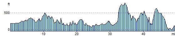
A super route though the South Downs from Horley to Brighton. The trail passes Crawley, Haywards Heath and Burgess Hill before finishing on the south coast. The walk has several train stations dotted along the route so you can easily do this one in manageable sections. Highlights include the Ardingly Nature Reserve and Ardingly Reservoir near Balcombe. Near here there's also fine views of the impressive Ouse Valley Viaduct, one of the most photographed sites on the path. The walk also climbs Ditchling Beacon where there are fabulous views of the South Downs.
Brighton Way Ordnance Survey Map  - view and print off detailed OS map
Brighton Way Open Street Map  - view and print off detailed map
*New* - Walks and Cycle Routes Near Me Map - Waymarked Routes and Mountain Bike Trails>>
Brighton Way OS Map  - Mobile GPS OS Map with Location tracking
Brighton Way Open Street Map  - Mobile GPS Map with Location tracking
Cycle Routes and Walking Routes Nearby
Photos

Ardingly Reservoir

Ouse Valley viaduct
Elevation Profile