Irthlingborough Walks
![]()
![]() This North Northamptonshire town is located in a nice spot on the River Nene.
This North Northamptonshire town is located in a nice spot on the River Nene.
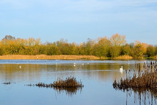
This circular walk in the town explores the Irthlingborough Lakes and Meadows Nature Reserve. The reserve is part of the wider Nene Wetlands and includes some lovely waterside footpaths with lots of wildlife to see.
Part of the walk runs along the Nene Way, a long distance walking trail running through the beautiful Nene Valley. You could extend the walk along the trail by heading north to visit neighbouring Ringstead or south to the lovely Irchester Country Park in Wellingborough.
Please scroll down for the full list of walks near and around Irthlingborough. The detailed maps below also show a range of footpaths, bridleways and cycle paths in the area.
Irthlingborough Ordnance Survey Map  - view and print off detailed OS map
Irthlingborough Open Street Map  - view and print off detailed map
Irthlingborough OS Map  - Mobile GPS OS Map with Location tracking
Irthlingborough Open Street Map  - Mobile GPS Map with Location tracking
Walks near Irthlingborough
- Finedon - This circular walk takes you around the Northamptonshire town of Finedon passing the old Finedon Hall and visiting Finedon Pocket Park
- Titchmarsh Nature Reserve - Enjoy waterside walking in this nature reserve in Thrapston, near Kettering
- Nene Way - Follow the River Nene through the beautiful Nene Valley on this fabulous walk through Cambridgeshire, Lincolnshire and Northamptonshire.
The long distance path runs for over 100 miles, passing Northampton, Wellingborough, Oundle, Peterborough and Wisbech.
There's much to enjoy on the way with rushing weirs, a series of historic villages and old mills - Stanwick Lakes - Explore 750 acres of parkland and nature reserve in the heart of Northamptonshire's beautiful Nene Valley
- Fermyn Woods - This country park and forest has a number of walking trails and two bridleways for cyclists
- Cransley Reservoir - This walk visits Cransley Reservoir from the village of Thorpe Malsor in Northamptonshire.
- Ringstead - This circular walk explores the countryside and neighbouring villages around the Northamptonshire village of Ringstead.
- Wellingborough - The Northamptonshire town of Wellingborough has some lovely walking trails to follow through the Nene Valley
- Thrapston - This walk from the Northamptonshire town of Thrapston takes you along the River Nene to the neighbouring village of Wadenhoe
- Rushden Lakes - This walk visits Rushden Lakes in the Nene Valley area of Northamptonshire
- Irchester Country Park - Enjoy numerous walking and cycling trails in this splendid country park in Wellingborough, Northamptonshire
- Sywell Country Park - Follow the waterside path around the delightful Sywell Reservoir on this easy walk in Northamptonshire
- Northampton Canal Walk - This easy walk follow the Northampton Arm of the Grand Union Canal from the town centre to the countryside near Milton Malsor
- Grand Union Canal Walk - Follow the towpath of Britain's longest canal from London to Birmingham on this fabulous waterside walk
- Ringstead - This circular walk explores the countryside and neighbouring villages around the Northamptonshire village of Ringstead.
- Summer Leys - This walk explores the Summer Leys Nature Reserve and the countryside around the village of Great Doddington near Wellingborough in Northamptonshire.
- Barnwell Country Park - Enjoy lovely waterside walking trails in this country park in Oundle, Northamptonshire
- Orlingbury - This Northamptonshire based village is located near the towns of Kettering and Wellingborough.
- Grafton Underwood - This walk visits the pretty Northamptonshire village of Grafton Underwood
Photos
View looking North across Corner Lake in December. The top of the lantern tower of St. Peter's Church can be seen behind the trees. The tower was built to guide travellers across the Nene valley in foggy weather. It also has doors at the four cardinal points and has eight misericords in the chancel.


