Laxfield Walk
![]()
![]() This walk visits the splendidly preserved medieval village of Laxfield in Suffolk.
This walk visits the splendidly preserved medieval village of Laxfield in Suffolk.
There are some wonderful old buildings in the village including traditional thatched cottages and timber-framed houses, which add to its quintessential English village atmosphere. Historic highlights include the 14th century church and the 16th century pub for refreshments after your exercise.
The walk starts in the village and follows a pleasant country lane into the surrounding farmland. It's a lovely rural area with fine views across the Suffolk countryside.
Please scroll down for the full list of walks near and around Laxfield. The detailed maps below also show a range of footpaths, bridleways and cycle paths in the area.
Postcode
IP13 8DR - Please note: Postcode may be approximate for some rural locationsPlease click here for more information
Laxfield Ordnance Survey Map  - view and print off detailed OS map
Laxfield Open Street Map  - view and print off detailed map
Laxfield OS Map  - Mobile GPS OS Map with Location tracking
Laxfield Open Street Map  - Mobile GPS Map with Location tracking
Walks near Laxfield
- Dennington - This Suffolk village is located close to Laxfield and Framlingham.
- Harleston - This town in South Norfolk has some pleasant river trails through the Waveney Valley and an attractive town centre with several Georgian buildings to admire.
- Halesworth - This Suffolk based market town has some nice trails along the Blyth River
- Framlingham Castle - This walk visits the 12th century Framlingham Castle and follows the public footpaths surrounding the attractive Suffolk based market town
- Saxmundham - This Suffolk based market town has some nice trails to try through the valley of the River Fromus
- Blythburgh - This small East Suffolk based village lies on the River Blyth near to Dunwich Forest, the Suffolk Coast National Nature Reserve and the Walberswick Nature Reserve
- Dunwich Forest - This large forest is located in the Suffolk Coasts and Heaths Area of Outstanding Natural Beauty in the village of Dunwich
- Dunwich Heath - This beautiful coastal heathland is a wonderful place for a peaceful circular walk
- Dunwich to Walberswick Walk - This circular walk takes you from Dunwich to Walkberswick on the Suffolk coast
- Southwold to Walberswick - This is a popular walk from Southwold to Walberswick, passing along the coast and the River Blyth
- Suffolk Coast Path - A walk along the beautiful Suffolk coast from Felixstowe to Lowestoft
- Suffolk Coast National Nature Reserve - This delightful coastal nature reserve is situated around the village of Walberswick in the Suffolk Coast and Heaths Area of Outstanding Natural Beauty
- Benacre - This circular walk explores the Benacre National Nature Reserve in the Suffolk Coast and Heaths AONB.
- East Suffolk Line Walks - Follow the 'East Suffolk Line' railway from Ipswich to Lowestoft on this splendid walk through the Suffolk countryside
- Southwold - This lovely circular walk takes you from the coastal town of Southwold to the nearby village of Walberswick in the Suffolk Coast and Heaths Area of Outstanding Natural Beauty
- Stradbroke - This Mid Suffolk based village has some good public footpaths to follow through the surrounding countryside.
- Hoxne Heritage Walk - This waymarked circular walk explores the area around the historic Mid Suffolk village of Hoxne.
Pubs/Cafes
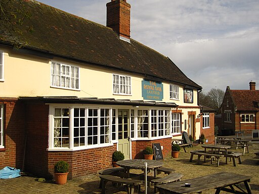
The Royal Oak dates to the 16th century still has many of its original features, including exposed beams and a cosy fireplace, creating a charming and traditional ambiance for patrons. They serve good food and have a garden area for warmer days. You can find them on the High Street at postcode IP13 8DH. The pub is dog friendly.
Further Information and Other Local Ideas
Just to the south there's neighbouring Dennington. The pretty village includes some historic buildings including a 16th century pub and a Grade I listed church dating to the medieval period.
Photos
The church of All Saints. One of the notable landmarks in Laxfield is the Church of All Saints, a medieval church with a distinctive round tower. This church is not only a place of worship but also a historical gem that reflects the village's heritage. It is largely of 14th century construct and was essentially completed by 1488.


