Llyn Brianne
![]()
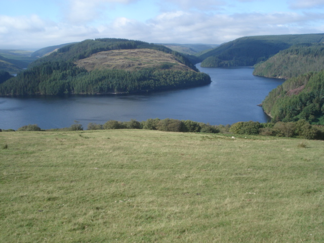
![]() Enjoy a walk or cycle along this beautiful reservoir in central Wales. The reservoir sits at the head of the River Towy with a dam 299 feet high and 951 feet long. There's a lovely country lane running along the eastern side of the water. It climbs high above the reservoir with wonderful views over the water to the surrounding countryside and hills. The lane is ideal for a quiet cycle ride in beautiful surroundings.
Enjoy a walk or cycle along this beautiful reservoir in central Wales. The reservoir sits at the head of the River Towy with a dam 299 feet high and 951 feet long. There's a lovely country lane running along the eastern side of the water. It climbs high above the reservoir with wonderful views over the water to the surrounding countryside and hills. The lane is ideal for a quiet cycle ride in beautiful surroundings.
The route starts from the car park at the southern end of the water and follows the track through the Tywi Forest before finishing at the bridge at the northern end of the reservoir. Look out for red squirrels as you pass through the forest. You can view the scenery and follow the route using the google street view link below.
To extend your walking in the area you could head to the Gwenffrwd-dinas RSPB Nature Reserve which is just to the south of the reservoir. Here you can enjoy great views of the River Towy and look out for red kites and a variety of butterflies.
Just to the north west of the lake you will find Soar y mynydd a Calvinist Methodist Church sitting in the valley of the river Camddwr in the Cambrian Mountains. It's claim to fame is that it is the remotest chapel in all Wales.
To the north east of the lake you will find the village of Abergwesyn, Vicarage Meadows and the pretty Nant Irfon National Nature Reserve. There's some nice woodland trails here with lots of bluebells in the spring.
Postcode
SA20 0PG - Please note: Postcode may be approximate for some rural locationsLlyn Brianne Ordnance Survey Map  - view and print off detailed OS map
Llyn Brianne Open Street Map  - view and print off detailed map
Llyn Brianne OS Map  - Mobile GPS OS Map with Location tracking
Llyn Brianne Open Street Map  - Mobile GPS Map with Location tracking
Explore the Area with Google Street View 
Pubs/Cafes
Head south from the lake into the little village of Rhandirmwyn for some refreshments after your exercise. Here you'll find a lovely old pub in the shape of The Royal Oak Inn. There's a good menu and a nice outdoor seating area with views of the Upper Towy Valley. The cosy interior has a good atmosphere and real log fires. They also provide accommodation so if you need to stay over to further explore the area it's a great choice. You can find the pub in the village at postcode SA20 0NY for your sat navs.
Dog Walking
The lakeside trails and the adjacent forest are ideal for a dog walk. The Royal Oak mentioned above is also dog friendly.
Further Information and Other Local Ideas
From the car park at the northern end of the lake you can pick up the Tywi Valley Walk. This will take you north along the river to Dolgoch, with waterfalls, mountains and the option of branching off to explore the expansive Tywi Forest.
To the east you can visit the Devil's Staircase in the Abergwesyn Pass. The spectacular mountain pass is a fine place for a walk or challenging cycle along the scenic winding road.
Cycle Routes and Walking Routes Nearby
Photos
The northern arms of Llyn Brianne The lake has a complex structure and the road up the east side at its highest point provides a good view of the two long northern arms.
Afon Tywi feeding Llyn Brianne. About one mile north of here is a weir with a tower containing lime which is automatically released into the river to neutralise its acidity before it enters the reservoir at Llyn Brianne. The cilycwm.com website gives this information: Llyn Brianne reservoir was originally built (1968-1972) to satisfy the growing demands of heavy industry in and around Swansea for water, notably the tin plate works at Felindre and a smelting plant at Llansamlet. Ironically, both these have since closed down and water from Llyn Brianne which is surplus to the Swansea area's needs now goes into the general supply, quenching thirsts all the way from Llanelli, across West and South Wales and as far East as Cardiff.
Llyn Brianne weir. Overflowing water pours over the weir at the top of the Llyn Brianne spillway as the day's weather looks set to be dominated by heavy rain.
View of the lake through the trees.This is towards the northern end of the Tywi arm. If felling of the trees by the water continues, it is likely that replanting will be with native deciduous trees.


