Oxwich Bay Circular Walk with OS Map
![]()
![]() This circular walk explores the area surrounding Oxwich Bay on the Gower Peninsula. The Travel Magazine named Oxwich beach the most beautiful in Britain.
This circular walk explores the area surrounding Oxwich Bay on the Gower Peninsula. The Travel Magazine named Oxwich beach the most beautiful in Britain.
You start at the car park in Oxwich and head along the coast through Oxwich Wood before continuing to Oxwich point where there are splendid coastal views. On the way you will pass the fascinating St Illtud's Church. Founded in the 6th century the church has an interesting stone font and tranquil grounds.
From Oxwich point you continue around the southern part of the headland with views over Port-Eynon Bay. Footpaths through the countryside then take you back to Oxwich via the fine ruins of Oxwich Castle. The route then heads through the lovely sand dunes of Oxwich Burrows Nature Reserve where you can look out for a variety of flora and fauna. These include more than 600 species of plants such as Bee Orchids and Early Marsh-orchids.
The area also includes a freshwater lake, salt marsh and the pretty stream of Nicholaston Pill. Look out for birds including Cetti's Warblers, Sedge Warblers and Bittern.
If you'd like to continue your exercise then you could try the Three Cliffs Bay Walk which visits Nicholaston Burrows and Penmaen Burrows. The video below shows a walk from Oxwich to Three Cliffs also. The atmospheric ruins of the 12th century Pennard Castle are near here and well worth a visit too.
Postcode
SA3 1LS - Please note: Postcode may be approximate for some rural locationsOxwich Bay Circular Ordnance Survey Map  - view and print off detailed OS map
Oxwich Bay Circular Open Street Map  - view and print off detailed map
*New* - Walks and Cycle Routes Near Me Map - Waymarked Routes and Mountain Bike Trails>>
Oxwich Bay Circular OS Map  - Mobile GPS OS Map with Location tracking
Oxwich Bay Circular Open Street Map  - Mobile GPS Map with Location tracking
Explore the Area with Google Street View 
Further Information and Other Local Ideas
The Oxwich to Port Eynon Walk starts from the same car park andf will take you west to the historic village of Port Eynon via Horton. It's a lovely walk passing along the coast with views of Port Eynon Bay and beach. In the village there's also a very fine pub for refreshments at the end of the walk.
Just to the east you can visit the delightful woodland trails at Bishopston Valley and visit the beautiful secluded beach at Pwll Du Bay.
For more walking ideas in the area see the Gower Walks page.
Cycle Routes and Walking Routes Nearby
Photos
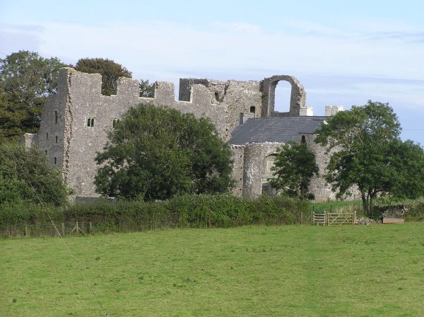
The 16th century Oxwich Castle. The walk passes the ruins of this Grade I listed castle to the south of the village. It is a castle in name only as it is was originally a grand Tudor fortified manor house built in courtyard style.
St Illtyd's Church. The parish church of St. Illtyd's overlooks Oxwich Bay. A place of worship has stood on this site since the 6th century, but the main tower of today was built in the 14th century. The chancel of this church is thought to be a 6th-century cell. The church bell in the tower also dates back to the 14th century, but was recast in 1892.


