Telscombe Cliffs Walk
![]()
![]() This walk takes you along the Telscombe Cliffs Esplanade in the Lewes District of East Sussex.
This walk takes you along the Telscombe Cliffs Esplanade in the Lewes District of East Sussex.
In the village there's a nice cliff top path with some splendid views over the coast. There is also access from the clifftop down steps to the quiet shingle beach.
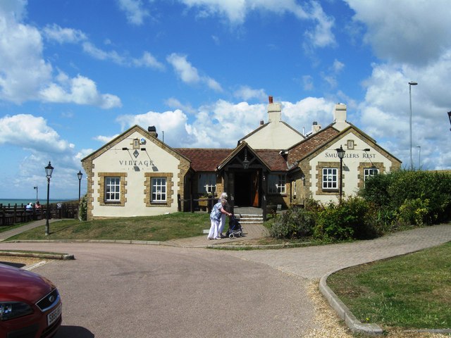
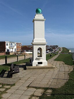
You can start the walk from the car park of the Smugglers Rest pub. From here you can follow the cliff top path east towards Peacehaven before finishing at the Meridian Monument. This monument marks where Peacehaven lies on the meridian. It's a great spot with more excellent sea views.
You can continue your walking along the popular Undercliff Walk which runs just below the cliffs.
Please scroll down for the full list of walks near and around Telscombe Cliffs. The detailed maps below also show a range of footpaths, bridleways and cycle paths in the area.
Postcode
BN10 7BE - Please note: Postcode may be approximate for some rural locationsTelscombe Cliffs Ordnance Survey Map  - view and print off detailed OS map
Telscombe Cliffs Open Street Map  - view and print off detailed map
Telscombe Cliffs OS Map  - Mobile GPS OS Map with Location tracking
Telscombe Cliffs Open Street Map  - Mobile GPS Map with Location tracking
Walks near Telscombe Cliffs
- Rottingdean - This attractive coastal village is located in the city of Brighton in East Sussex
- Brighton - Brighton has some lovely coastal walks and splendid hill climbs on the nearby South Downs.
One of the most popular is the Undercliff Walk which takes you from Brighton Marina to Saltdean along the sea wall - Undercliff Walk Brighton - Follow the Undercliff Walk from Brighton Marina to Saltdean on this exhilarating coastal walk or cycle
- Brighton to Newhaven - Follow the Brighton to Newhaven clifftop path on this splendid coastal walk on the south coast
- Brighton to Eastbourne - This coastal walk takes you between these two major Sussex settlements
- Iford - A circular walk from the Sussex village of Iford, visiting the River Great Ouse and the neighbouring villages of Southease and Rodmell.
The village sits just a couple of miles south of Lewes on slopes of the South Downs in the valley of the River Ouse - Castle Hill Nature Reserve - This circular walk visits the Castle Hill National Nature Reserve on the eastern outskirts of Brighton in the South Downs National Park
Pubs/Cafes
The Smuggler's Rest was formerly known as the Badgers Watch and before that, the Lifeboat Inn, as it funded the first local lifeboat. They have some lovely gardens with fine views over the coast. The pub is dog friendly and can be found at postcode BN10 7BE.
Photos
Looking east from the footpath along the clifftop. The area was developed from the first decade of the twentieth century onwards on land leased by Ambrose Gorham, then the major landowner in Telscombe. The cream buildings in the centre of the picture are now the Badger's Watch pub. Prior to that they were early 19th century coastguard cottages and the only buildings to be found along this stretch of the cliffs before 1900.
The point where Telscombe Cliffs becomes Peacehaven also means a change in cliff top road layout. There is some distance between houses and cliff edge in the former whilst the houses in the latter have an unmade road and fence before the cliff edge is reached. However, the section below the cliff is now protected by the sea defences constructed in stages between 1976-96. The Promenade itself is indicative of Peacehaven's development starting here and finishing above Friar's Bay on the eastern boundary of the town but split into sections by parks and a lack of roadway.


