Toddington Walk
![]()
![]() This Bedfordshire based village sits on a major long distance trail and is surrounded by some lovely Chilterns countryside.
This Bedfordshire based village sits on a major long distance trail and is surrounded by some lovely Chilterns countryside.
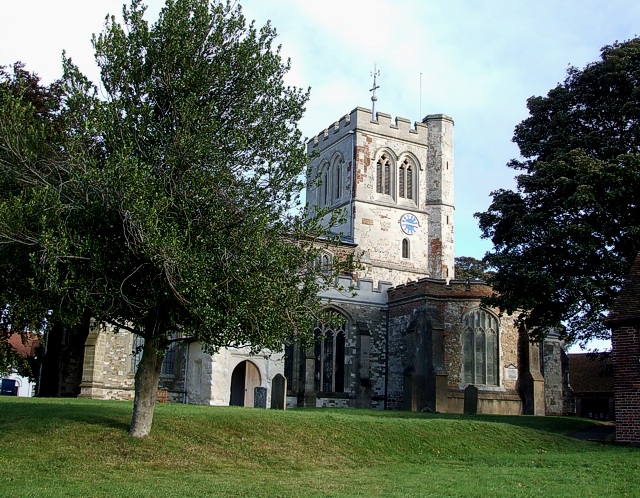
There's also a picturesque village green, a fine market square, a 13th century church and several good pubs for rest and refreshment after your exercise.
This circular walk from the village uses sections of the Icknield Way Path, the John Bunyan Trail, the Chiltern Way and other public footpaths to visit two of the local walking highlights at Sundon Hills Country Park and Sharpenhoe Clappers.
The route starts on the eastern side of the village where you can pick up the Icknield Way Path and follow the waymarked trail east to the Sundon Hills, crossing the train line and the M1 motorway as you go.
The route then heads north east where you climb to the National Trust's Sharpenhoe Clappers. Here you'll find a classic chalk escarpment with woodland trails and fine views over the surrounding Chilterns countryside.
The route then heads south, passing through the Smithcombe Valley before coming to the village of Streatley. You then head west back through the country park before turning south to visit Upper Sundon. The final section then follows bridle track west to Horse Hill Farm where you pick up the Icknield Way again and follow it north west to return to Toddington.
The walk can easily be extended at the eastern end to visit Barton Hills National Nature Reserve where there's lots more interesting flora and fauna to see.
Postcode
LU5 6BP - Please note: Postcode may be approximate for some rural locationsToddington Ordnance Survey Map  - view and print off detailed OS map
Toddington Open Street Map  - view and print off detailed map
Toddington OS Map  - Mobile GPS OS Map with Location tracking
Toddington Open Street Map  - Mobile GPS Map with Location tracking
Walks near Toddington
- Sundon Hills Country Park - Climb to a height of over 500 feet and enjoy wonderful views over the Bedfordshire countryside on this circular walk near Luton
- Sharpenhoe Clappers - Visit this classic chalk escarpment in the Chilterns and enjoy wonderful views across this beautiful area
- Dunstable Downs Country Park - Climb Dunstable Downs and enjoy breathtaking views over the Chilterns Area of Outstanding Natural Beauty on this circular walk in Whipsnade
- Barton Hills - Visit the Barton Hills National Nature Reserve and enjoy peaceful walking trails in the Chilterns
- Ickleford River and Nature Reserve Circular Walk - This attractive Hertfordshire based village is located just north of Hitchin on the west bank of the River Hiz
- Woburn Park - This walk takes you through the beautiful Woburn Park in Befordshire
- Wrest Park - Explore 92 acres of landscaped early eighteenth-century garden in this lovely walk in Silsoe
- Aspley Woods - These 800 acre woods near Milton Keynes have some good mountain bike trails and miles of footpaths.
- Bow Brickhill - This walk explores the woodland to the east of the village of Bow Brickhill in the Borough of Milton Keynes.
- Rushmere Country Park - Explore 400 acres of lakes, ancient woodland conifer plantations, meadows and heath in this country park in Leighton Buzzard
- Pegsdon Hills - Enjoy a climb to Deacon Hill and enjoy wonderful views over the Chilterns on this walk in the Pegsdon Hills
- Leighton Buzzard - This Bedfordshire based market town is located close to a canal, two fine country parks and the Chiltern Hills AONB
- Oughtonhead Common - This walk takes you around the Oughtonhead Common Nature Reserve in Hitchin.
- Luton - This Befordshire based town has nice walks along the River Lea and is also close to the Chilterns Hills AONB where there are excellent walking opportunites
Pubs/Cafes
Back in the village you can enjoy post walk rest and refreshment at the Oddfellows Inn. The friendly old pub dates back over 700 years and is located in a nice spot on the Market Square at postcode LU5 6BP for your sat navs. There's a cosy interior and nice garden area for warmer weather.
Dog Walking
The woodland, parkland and country trails on the route make for a fine dog walk. The Oddfellows mentioned above is also dog friendly.
Photos
Market Square. Taken from the churchyard of the Parish Church of St. George of England looking across to the green area in the middle of Toddington. This green is bounded by Market Square. The War Memorial can be seen ahead on the left, it is in the angle made by the junction of Church Square and Market Square.
From Sundon Hills, looking North east. Sundon Hills are believed to be the inspiration for 'The Delectable Mountains' in John Bunyan's 'The Pilgrim's Progress'.


