West Wycombe Park Walks Map
![]()
![]() Explore the beautiful estate surrounding West Wycombe House on this walk in the Chilterns AONB. The Palladian house has 45 acres of landscaped gardens with a lovely large lake, views of the River Wyre, woodland paths and sweeping lawns to enjoy. Look out for attractive temples and follies such as the Temple of the Four Winds.
Explore the beautiful estate surrounding West Wycombe House on this walk in the Chilterns AONB. The Palladian house has 45 acres of landscaped gardens with a lovely large lake, views of the River Wyre, woodland paths and sweeping lawns to enjoy. Look out for attractive temples and follies such as the Temple of the Four Winds.
After strolling round the grounds you can climb to West Wycombe Hill for wonderful views over the Chilterns countryside. At the top of the hill you will find the 18th century Mausoleum. It is also a great spot to look out for the Red Kite.
After descending the hill you can then continue your walk through miles of surrounding woodland and head towards nearby Bradenham.
The village of West Wycombe also has many interesting features such as the Grade I listed church and the popular Hellfire Caves. This extraordinary network of man-made chalk and flint caverns is well worth a visit.
If you'd like to extend your walk then you can head to the nearby Hughenden Park with its gardens, parkland, woodland and and riverside paths. Our longer circular walk from nearby High Wycombe takes in Hughenden, Naphill Common and Downley Common.
There's lots of nice woodland trails and interesting flora and fauna to see on the commons.
Postcode
HP14 3AJ - Please note: Postcode may be approximate for some rural locationsPlease click here for more information
West Wycombe Park Ordnance Survey Map  - view and print off detailed OS map
West Wycombe Park Open Street Map  - view and print off detailed map
*New* - Walks and Cycle Routes Near Me Map - Waymarked Routes and Mountain Bike Trails>>
West Wycombe Park OS Map  - Mobile GPS OS Map with Location tracking
West Wycombe Park Open Street Map  - Mobile GPS Map with Location tracking
Walks near West Wycombe
- Hughenden Manor Park - The 1,500 acres of parkland surrounding the red brick Victorian mansion of Hughenden Manor is great for a short walk in lovely surroundings
- High Wycombe - This large Buckinghamishire town is a great place to go for a country walk with some several attractive woodland areas, views of the Chiltern Hills and the wonderful Hughenden Park to enjoy
- Bledlow Ridge - This Buckinghamshire based village has some fine country walks into the surrounding Chiltern Hills
- Chinnor - This village in South Oxfordshire is in a fine location for walkers with hill climbs and large areas of woodland right next to the settlement
- Princes Risborough - This Buckinghamshire based town is in a great location for exploring the beautiful Chiltern Hills AONB.
This walk from the town's train station takes you to some of the highlights of the area - Bradenham Woods - This circular walk explores the woodland and countryside surrounding the pretty village of Bradenham in the Chilterns
- Downley Common - This walk visits Downley Common next to the Buckinghamshire village of Downley in the Chilterns near High Wycombe.
- Stokenchurch - This Buckinghamshire based village has some lovely trails to follow through the surrounding Chilterns countryside
- Aston Rowant Nature Reserve - Enjoy a circular walk around this wonderful nature reserve in the Chilterns and climb Beacon Hill on the way
- Saunderton - This Buckinghamshire based village is well served by a series of footpaths running into the glorious rolling Chilterns countryside.
Pubs/Cafes
Head into the village and you can enjoy some post walk refreshment at The George and Dragon Hotel. The 18th century inn serves high quality food and have a nice outdoor seating area in the back. You can find them on the High Street at postcode HP14 3AB for your sat navs.
Dog Walking
No dogs are allowed inside the National Trust park grounds but there are woodland trails on public footpaths to the north of the village in Hearnton Wood. There's also miles of dog friendly trails just to the north east on Downley Common and Naphill Common. The George and Dragon Hotel is also dog friendly.
Further Information and Other Local Ideas
The circular Bledlow Ridge Walk can be picked up to the north west of the town. It's an attractive settlement which includes a fine old pub and the Yoesden Wood Nature Reserve where there's some interesting flora and fauna to observe.
For more walking ideas in the area see the Buckinghamshire Walks, Chilterns Walks page.
Photos
West Wycombe House Park and West Wycombe Hill, with the Mausoleum and church within a prehistoric camp on its summit, as seen from the parkland of the National Trust owned House.
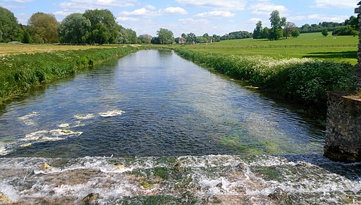
River Wye in the park. Leaving the lake over this wide weir, the river is still an ornamental feature of the park right up to the far boundary.
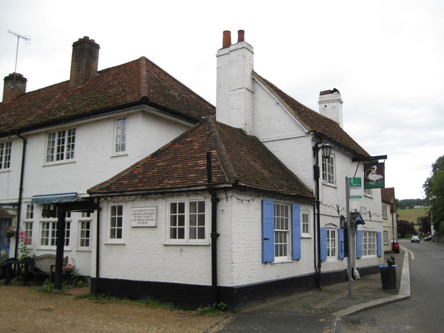
The Swan Inn in the village. With the exception of the Village Hall, every building on the south side of the High Street in West Wycombe is listed. This is The Swan Inn with a later extension to the rear. Also in the photograph is The Swan Inn bus stop. The weekday hourly bus service to Stokenchurch, Chinnor and Thame stops here.


