Brockham Walks
![]()
![]() This award winning village sits in a fine spot in the Mole Valley of Surrey. It's a wonderful place for walkers with several major waymarked footpaths passing through the area. It's a picturesque place with a village green, pretty cottages and a fine old church to see.
This award winning village sits in a fine spot in the Mole Valley of Surrey. It's a wonderful place for walkers with several major waymarked footpaths passing through the area. It's a picturesque place with a village green, pretty cottages and a fine old church to see.
This circular walk from the village makes use of sections of the Greensand Way, the Mole Gap Trail and the North Downs Way to visit some of the highlights of the surrounding area. On the walk you'll pass the popular Box Hill Country Park, Brockham Quarry Nature Reserve, Denbies Hillside, Ranmore Common and the neighbouring town of Dorking.
The walk starts in the village and first heads north to Betchworth Park, passing the golf course and Betchworth Castle. After crossing the railway line you will come to Brockham Quarry Nature Reserve. The interesting site was once the site of chalk extraction and the lime making industry during the Victorian Era.
After exploring the quarry you come to Box Hill where there are miles of great woodland walking and cycling trails with fine views from the high points.
You continue west past Westhumble to Denbies Hillside which contains wildflowers, wayamarked trails and an informative visitor centre and the largest vineyard in England.
The route continues through the adjacent Ranmore Common where there's more peaceful woodland and open downland, with great views of the Surrey Hills. From here you head south along the Greensand Way to Westcott where you turn east past Bury Hill and the fishing lake. The final stretch takes you through Dorking town before returning to Brockham.
Postcode
RH3 7JS - Please note: Postcode may be approximate for some rural locationsBrockham Ordnance Survey Map  - view and print off detailed OS map
Brockham Open Street Map  - view and print off detailed map
Brockham OS Map  - Mobile GPS OS Map with Location tracking
Brockham Open Street Map  - Mobile GPS Map with Location tracking
Walks near Brockham
- Betchworth - This small village is located near Dorking in Surrey
- Dorking - A long circular walk around the Surrey Hills town of Dorking, making use of some of the fine waymarked trails which run through the area
- Ranmore Common - This circular walk explores Ranmore Common in the North Downs, near Dorking
- Polesden Lacey - A walk around the beautiful grounds of this Edwardian house at Great Bookham, near Dorking, Surrey
- Holmwood Common - This National Trust managed common has miles of walking trails to try
- Abinger Common - Enjoy a walk across Abinger and Wotton Commons before a climb to Leith Hill on this circular walk in the Mole Valley
- Pilgrims Way - Follow in the footsteps of the pilgrims who followed this ancient track from Winchester in Hampshire, to the shrine of Thomas Becket at Canterbury in Kent
- Mole Gap Trail - Follow the Mole Gap Trail from Leatherhead to Dorking on this pleasant short walk through the Surrey countryside
- Denbies Hillside - Explore this lovely area of the North Downs on this short circular walk
- Box Hill Country Park - This park is run by the National Trust and has a number of splendid walking trails to enjoy
- Headley Heath - Enjoy cycling and walking trails in this large area of open heathland, woodland and chalk downland in the Surrey Hills
- Leith Hill - Climb to the highest point in the South East on this challenging circular walk in the Surrey Hills AONB.
- Friday Street - This pretty little hamlet sits in a pleasant location on the slopes of Leith Hill in Surrey.
Pubs/Cafes
Head to the Inn on the Green for some refreshments after your exercise. The pub sits in a fine spot overlooking the photogenic village green. They serve good quality dishes and have a pleasant outdoor area for warmer days. You can find them at postcode RH3 7JS for your sat navs.
Dog Walking
The woodland and country trails are ideal for a dog walk. The Inn mentioned above is also dog friendly.
Photos
View south across part of Brockham Green, Surrey. On the left is Vicarage Cottage, which is probably 17th-century. On the right is All Saints' parish church
Bridges over the River Mole, Brockham. Just north of Brockham Green are these two separate bridges: a single-track road bridge for cars, and a separate 'safe' footbridge for pedestrians.
The Borough, Brockham, Surrey. This lane leads westwards from just north of the bridge over the River Mole. The nearer cottages, with three storeys, are of interest. Perhaps the top storey was intended for some sort of home industry, although little light can have been admitted by the small dormer windows.
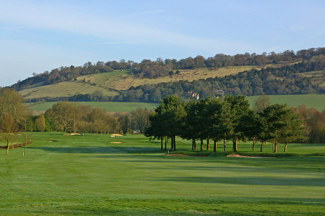
Towards Box Hill. Looking towards Box Hill from Betchworth Park Golf Course. The prominent house above the stand of trees is Boxhurst.


