Penarth Walks
![]()
![]() The town of Penarth is based on the South Wales coast in the Vale of Glamorgan near Cardiff. It has some lovely walking trails to try along the Wales Coast Path which runs through the town.
The town of Penarth is based on the South Wales coast in the Vale of Glamorgan near Cardiff. It has some lovely walking trails to try along the Wales Coast Path which runs through the town.
This walk takes you along the cliff top to the nearby Cosmeston Lakes Country Park where you can enjoy lakeisde trails with 200 acres of woodland, meadows and wetland habitats to enjoy. It's about a 3 mile walk from the seafront the park, with nice views of the beach as you go.
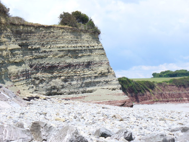
The walk starts on the sea front in Penarth next to the pier. The town is located at the top of limestone cliffs that have a distinctive rock formation and are referred to as the Penarth Group of rocks. From the pier you proceed south along the coastal path to the noteworthy Lavernock Point, enjoying great views of the Bristol Channel on the way. Here you will find a lovely nature reserve with varied and colourful plants and several species of butterfly to look out for. The area is also well known as the place where Guglielmo Marconi transmitted and received the first wireless signals over open sea between the Point and Flat Holmisland in the late 19th century.
At Lavernock Point you turn inland to follow footpaths to Cosmeston Lakes. The park includes a visitor centre and a number of well laid out paths. There's also a number of bird hides where you can look out for mute swans, mallards, herons, egrets and diving birds such as the great crested grebe.
On the other side of the Penarth Flats you can pick up the popular Taff Trail and follow it along the River Taff to Bute Park. Here you'll find 130 acres of landscaped gardens and parkland with an arboretum, flower gardens, grassland, woodland and tree-lined avenues.
Our longer Cardiff Coastal Walk passes through Penarth and will take you all the way to the popular holiday resort of Barry Island.
Penarth Ordnance Survey Map  - view and print off detailed OS map
Penarth Open Street Map  - view and print off detailed map
*New* - Walks and Cycle Routes Near Me Map - Waymarked Routes and Mountain Bike Trails>>
Penarth OS Map  - Mobile GPS OS Map with Location tracking
Penarth Open Street Map  - Mobile GPS Map with Location tracking
Walks near Penarth
- Cosmeston Lakes Country Park - Explore over 200 acres of woodland, meadows and wetland habitats in this popular country park in Penarth.
Cosmeston Lakes has a number of accessible gravel paths and wooden boardwalks taking you around and between the two large lakes which form the centrepiece of the park - Taff Trail - Follow the River Taff, from Cardiff to Brecon, on this fantastic waterside cycling and walking route.
You start on the River Taff in Cardiff and head along the river northwards passing the Millennium Stadium and Cardiff Castle - Bute Park - Explore 130 acres of landscaped gardens and parkland in this beautiful park in Cardiff
- Cardiff - Cardiff has some fine walks along the coast and great riverside trails along the River Taff
- Garth Hill - This challenging walk takes you to the summit of Garth Hill or Mountain near Cardiff
- Taff Ely Ridgeway Walk - Follow the Taff Ely Ridgeway Walk/Ffordd y Bryniau through the Ely Valley and Taff Vale on this walk in South Wales
- Cardiff Bay to Penarth Walk - This walk takes you from Cardiff Bay to the seafront at Penarth
- Dinas Powys Woodland and Salmon Leaps - This village (also known as Dinas Powis) is located a few miles from Cardiff in the Vale of Glamorgan
- Cardiff Bay Trail - This circular cycle and walking trail takes you around Cardiff Bay along part of Sustrans National Cycle Route 8.
- Sully Island - This walk takes you to Sully Island in the Vale of Glamorgan.
- Penarth to Sully Coastal Walk - This walk takes you along a section of the Wales Coast Path from Penarth to Sully Island
- Flat Holm - Flat Holm Island, known in Welsh as Ynys Echni, is a small island in the Bristol Channel, approximately 6 km (4 miles) from Lavernock Point in the Vale of Glamorgan
Further Information and Other Local Ideas
Head west from Penarth and you will soon come to the neighbouring village of Dinas Powys. The circular Dinas Powys Walk will take you through the local woods to the Cadoxton River. The river is one of the shortest in Wales and includes weirs and a salmon leap.
Near Cosmeston Lakes you can visit the lovely Sully Island. You can reach the island at low tide from the hamlet of Swanbridge.
Photos
Beacon at Penarth. Sited on the clifftop, a light here would be seen from up and down the Severn Estuary, and from the Somerset hills, on a clear night.
Triassic mudstone rock platform at Roundbush Rocks. The spit of Ranny Point runs out into the Bristol Channel with the coast of Somerset seen across the water. The islands of Flat Holm and Steep Holm occupy centre position within the channel.


