Shepshed Walks
![]()
![]() This interesting town is located near Loughborough in the Charnwood area of Leicestershire.
This interesting town is located near Loughborough in the Charnwood area of Leicestershire.
This walk from the town visits two of the highights of the area at Blackbrook Reservoir and the historic Mount St Bernard Abbey.
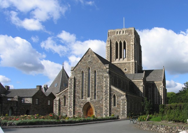
The walk starts in the town and follows path south to White Horse Wood and Blackbrook Reservoir where there are fine views across the water. You cross the southern end of the water passing Moult Hill and Drybook Wood before coming to Mount St Bernard Abbey. The abbey dates from 1835 and is notable as the first permanent monastery to be founded in England since the Reformation. The abbey monks are also known for brewing "Tynt Meadow" the only Trappist beer in Britain.
Near the abbey you could extend the walk by heading to another local historic landmark at the 13th century Grace Dieu Priory. The anicent ruins of the priory are surrounded by some pleasant woodland with trails along the Grace Dieu brook.
After exploring the abbey the route returns to the village on the same paths.
Postcode
LE12 9AA - Please note: Postcode may be approximate for some rural locationsShepshed Ordnance Survey Map  - view and print off detailed OS map
Shepshed Open Street Map  - view and print off detailed map
Shepshed OS Map  - Mobile GPS OS Map with Location tracking
Shepshed Open Street Map  - Mobile GPS Map with Location tracking
Walks near Shepshed
- Blackbrook Reservoir - This short walk visits Blackbrook Reservoir near Coalville in Leicestershire
- Thornton Reservoir - Enjoy cycling and walking around this pretty reservoir in Thornton, Leicestershire
- Ivanhoe Way - Travel through the setting of Sir Walter Scott's 19th century novel on this circular walk around Ashby-de-la-Zouch in Leicestershire.
The path starts Ashby-de-la-Zouch and first heads to Moira where you will follow the Ashby Canal for a short stretch - Charnwood Forest - This long circular walk explores the parks, woodland, hills, nature reserves and countryside in the attractive Charnwood Forest area of Leicestershire
- Loughborough Canal Walk - A waterside walk from Loughborough to Leicester along a section of the Grand Union Canal and the River Soar
- Watermead Country Park - This beautiful country park contains over 12 lakes and ponds, wildflower meadows, woodland, grassland and reedbeds set in 350 acres of parkland
- Bardon Hill - Climb to the highest point in Leicestershire on this walk near Coalville
- Mount St Bernard Abbey - Visit this Cistercian monastery near Coalville on this short walk
- Coalville - This Leicestershire based town is close to a number of peaceful woodland areas and an excellent viewpoint at the high point in the county.
- Moira Furnace - This attraction in Moira includes a 36 acre country park with walking and cycling trails along the Ashby Canal
- Woodhouse Eaves - This attractive Leicestershire village has several local country parks and two nearby reservoirs for walkers to explore.
- Grace Dieu Priory - This historic 13th century priory is located close to Coalville in North West Leicestershire.
- Charnwood Forest Railway - This walk takes you along a section of the old Charnwood Forest Railway in Loughborough.
Pubs/Cafes
The Pied Bull is a good choice for some post walk refreshment. The attractive thatched pub is the oldest in the village. Inside there's a charming interior with oak beams, while outside there's a lovely leafy garden for warmere days. You can find them at 49 Belton Street with postcode LE12 9AA for your sat navs.
Dog Walking
The country and woodland trails make for a fine dog walk and the Pied Bull mentioned above is also dog friendly.
Further Information and Other Local Ideas
On the northern side of the town there's the picturesque Shepshed Water Mill to visit. The restored 11th century mill includes a blacksmith workshop and a tea room. It's a nice place for a stroll with a pretty mill pond and the opportunity to learn about the history of the milling process. You can find them on Hathern Road at postcode LE12 9RP.
To the west of the town you could pick up the Ivanhoe Way and follow it south to visit the pretty Thornton Reservoir and the adjacent Bagworth Heath Woods.
Head east and you can pick up the Loughborough Canal Walk along the Grand Union Canal and visit the nearby village of Barrow upon Soar.
Just to the south west of the town you can climb to the highest point in Leicestershire at Bardon Hill.
For more walking ideas in the area see the Leicestershire Walks page.
Photos
Shepshed Water Mill - millpond. Taken at the grid reference, facing north. Shepshed Water Mill has been fully restored as a working mill, and is open to the public on special days. The M1, built in the 1960s, crosses the Shepshed-Hathern road, just 200 m south of the Water Mill.


