Wolverhampton Canal Walk
![]()
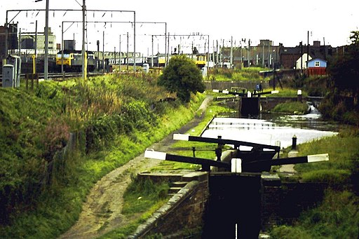
![]() Explore the Birmingham Canal on this short walk through the centre of Wolverhampton.
Explore the Birmingham Canal on this short walk through the centre of Wolverhampton.
It's a nice gentle stroll taking you past a series of locks, barges and bridges.
The route starts at the Broad Street Basin, very close to the train station. It then heads north, passing some pretty 18th century lock cottages, the Dunstall Railway Bridges and Wolverhampton Racecourse on your left. The route finishes at Aldersley Junction where the Birmingham Main Line Canal terminates and meets the Staffordshire and Worcestershire Canal near to Oxley.
At the end of this short route you have the option of extending your walk along the Staffordshire and Worcestershire Canal. Follow it south and it will take you to Wombourne.
Also near Oxley you can pick up the Shropshire Union Canal. Following it north will take you towards Brewood via the Pendeford Mill Nature Reserve.
Wolverhampton Canal Walk Ordnance Survey Map  - view and print off detailed OS map
Wolverhampton Canal Walk Open Street Map  - view and print off detailed map
Wolverhampton Canal Walk OS Map  - Mobile GPS OS Map with Location tracking
Wolverhampton Canal Walk Open Street Map  - Mobile GPS Map with Location tracking
Walks near Wolverhampton
- Staffordshire and Worcestershire Canal - Follow the Staffordshire and Worcestershire Canal from Stourport-on-Severn to Great Haywood on this easy waterside walking and cycling route
- Shropshire Union Canal - Travel from the ourskirts of Wolverhampton to Ellesmere Port on this long distance waterside walk along the Shropshire Union Canal.
The route starts at Autherley Junction in the Oxley area of Wolverhampton - Brewood Canal Walk - This circular walk from Brewood takes you along a section of the Shropshire Union Canal towards Wheaton Aston before heading through the countryside to visit the pretty Belvide Reservoir and the historic Chillington Hall.
- Belvide Reservoir - Enjoy a circular walk around Belvide Reservoir in South Staffordshire on this easy route
- Wombourne Railway Walk - A circular walk from Wombourne taking you along a dismantled railway line before returning along the Staffordshire and Worcestershire Canal
- Baggeridge Country Park - Enjoy 150 acres of woodland and countryside in this country park near Wolverhampton
- Netherton Tunnel - This walk explores the northern end of the Netherton Tunnel Canal in Birmingham.
- Dudley Canal - Follow the Dudley Canal from Warren's Hill Park to Leasowes Park on this waterside walk through Blackheath and Halesowen in Birmingham
- Wyrley and Essington Canal - This walk takes you along the Wyrley and Essington Canal from Wolverhampton to the Rushall Canal in Walsall.
- Rough Wood Country Park - This walk explores Rough Wood Country Park in Willenhall, Walsall
- Pelsall Common - This walk visits the Pelsall North Common nature reserve in the village of Pelsall, Walsall.
- Himley Hall - This walk explores Himley Hall Park, near the village of Himley in Staffordshire.
- Wightwick Manor - This walk visits the Victorian manor house of Wightwick Manor in Wolverhampton
- Smestow Valley - This walk explores the Smestow Valley Local Nature Reserve in Wolverhampton.
Further Information and Other Local Ideas
To continue your walking around Wolverhampton, head north and you can try the circular Brewood Canal Walk. This visits the pretty Belvide Reservoir and the Georgian country house of Chillington Hall with its Capability Brown landscaped park and lake. The noteworthy Weston Park is located just west of Belvide Reservoir and north west of Chillington Hall. There's more than 1000 acres of landscaped parkland surrounding this 17th century country mansion.
Just to the south west you can pick up the circular Wombourne Railway Walk which takes you along a section of the old Wolverhampton to Dudley railway line before visiting the pretty Bratch Locks on the Staffordshire and Worcestershire Canal. This route forms part of the longer South Staffordshire Railway Walk which runs from Wolverhampton's Aldersley Stadium to Pensett.
To the south of the city centre there's the popular Baggeridge Country Park. There's good cycling and walking trails here with woodland and a viewpoint with fine views over the city and surrounding countryside. Adjacent to the park there's also the 18th century Himley Hall. The historic hall is surrounded by ‘Capability’ Brown landscaped parkland with woodland walks, waterfalls and a large lake.
Head south along the Birmingham Canal and you could visit the Victorian Netherton Tunnel at Dudley Port. You can walk through the dark tunnel (with a torch) to link up with the Dudley Canal at Warren's Hill Park.
The Wyrley and Essington Canal starts in the city and will take you to the oak woodland in Rough Wood Country Park, the wildlife rich Pelsall Common Nature Reserve and then on to the Rushall Canal in Walsall.
For more walking ideas in the area see the West Midlands Walks page.


