Aberystwyth to Tregaron - Ystwyth Trail
![]()
![]() This lovely ride follows National Cycle Route 82 and the beautiful Ystwyth trail from Aberystwyth to Tregaron.
This lovely ride follows National Cycle Route 82 and the beautiful Ystwyth trail from Aberystwyth to Tregaron.
The trail mostly follows off road tracks which are made up of the tracked of a disused railway line. The ride begins by following the River Ystwyth before passing through the splendid Cors Caron with its variety of wildlife. You finish in the pretty village of Tregaron.
Aberystwyth to Tregaron Ordnance Survey Map  - view and print off detailed OS map
Aberystwyth to Tregaron Open Street Map  - view and print off detailed map
Aberystwyth to Tregaron OS Map  - Mobile GPS OS Map with Location tracking
Aberystwyth to Tregaron Open Street Map  - Mobile GPS Map with Location tracking
Explore the Area with Google Street View 
Cycle Routes and Walking Routes Nearby
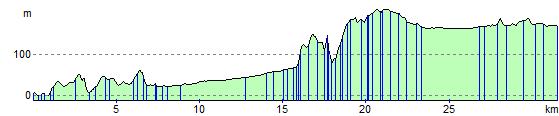
Photos

Ystwyth Trail near Allt Ddu. Although this is the valley of the Teifi, the cycle path that follows the old alignment of the railway line from Aberystwyth to Caerfyrddin/Carmarthen is known as the Ystwyth Trail. It follows the Ystwyth valley for most of its length before climbing up to meet the Teifi as it enters Cors Caron. The lake in the background is probably man-made and is surrounded by improved land by the side of the bog.

Ystwyth Trail, Cors Caron Nature Reserve. The trail follows the alignment of the old railway line from Aberystwyth to Caerfyrddin/Carmarthen, which closed in 1964. Between Ystradmeurig (and the former Strata Florida halt , which isn't anywhere near Strata Florida ) and Tregaron, it runs in a straight line along the eastern edge of the extensive bogland of Cors Caron. The trail doubles as one of the three routes offered by the reserve to walkers.

The trail at Ystrad Meurig. Here following the old railway line and approaching the site of Strata Florida station, where it merges with the existing nature trail following the railway across Cors Caron (Tregaron Bog).

Afon Ystwyth from the trail.

Site of Alltddu Halt. The parking area here was originally created to serve Alltddu Halt on the Manchester & Milford Railway, whose line passed along the top of the embankment on the left. Until recently there were stone steps in the embankment which gave access to the platform of the halt, which served a number of farms and cottages between here and Pontrhydfendigaid. Since the closure of the railway in 1965 the car park and track bed have been used to give access to the Cors Caron nature reserve, although a new alternative car park with toilets has recently opened about half a mile to the south, while the track bed has been incorporated in the Ystwyth Trail, for walkers and cyclists, between Tregaron and Aberystwyth.

Near Pen-rhiw. Here descending on the trackbed of the old Carmarthen to Aberystwyth railway line; the railway between here and Tynygraig to the south was on a steep gradient, and involved a number of cuttings and embankments.

Old railway bridge at Ystrad Meurig
Elevation Profile