Yorkshire Dales Walks

Use the links to view full route information including elevation profiles, interactive maps and GPS downloads.
You can also view an overview map of all the routes in the using the Yorkshire Dales Walk Map>>
*New* - Walks and Cycle Routes Near Me Map - Waymarked Routes and Mountain Bike Trails>>
| Route Name | Photo | Distance | Description |
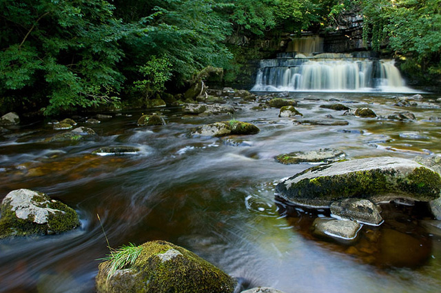
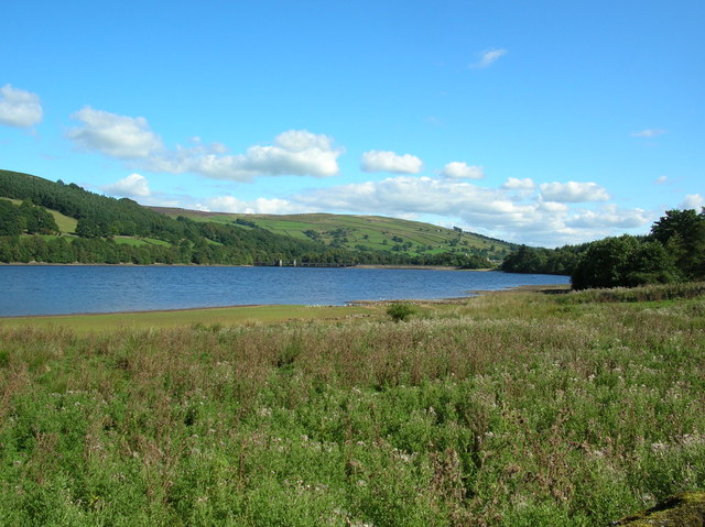
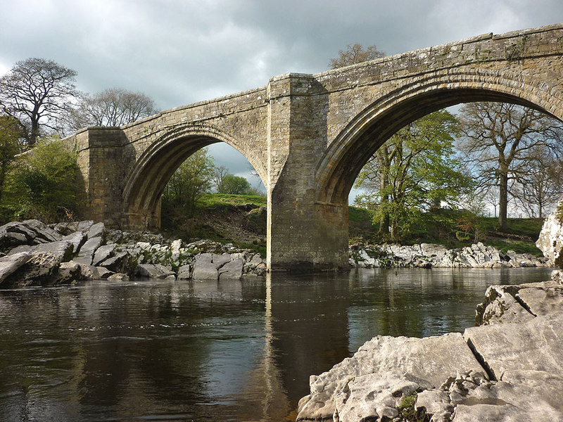
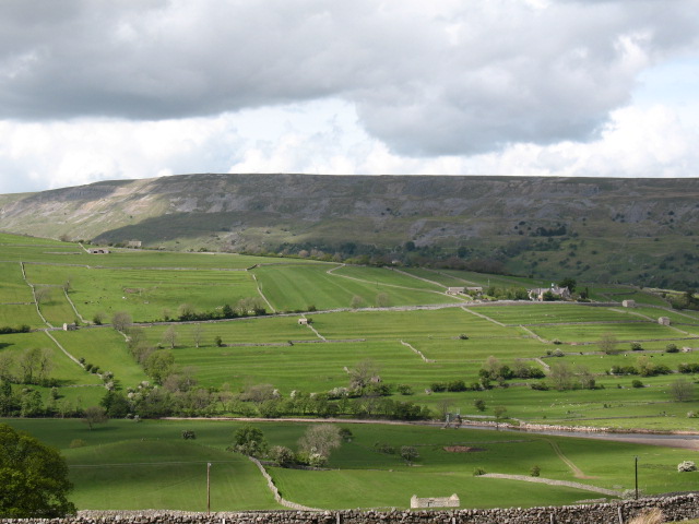
| Appletreewick | 9.9 miles (16 km) | This circular walk takes you to some of the highlights around the small village of Appletreewick in the Craven district of North Yorkshire. The 10 mile walk includes waterside sections along becks and rivers, a section through a wonderful limestone gorge and a visit to a lovely reservoir. Starting in the village you first head east towards Skyreholme where you pick up a nice waterside path along the Skyreholme Beck. Follow the beck north and you will come to Troller's Gill, where you will find a picturesque limestone gorge. After passing through the unusual gorge you turn west at Gill Head toward Appletreewick Pasture. The route then turns north to follow footpaths to Grimwith Reservoir. The good sized lake is great for bird watching, with wildfowl including wigeon, teal, greylag geese and Canada geese to see on the water. After enjoying the lake you turn south across Hartlington Pasture toward Dibble's Bridge by the River Dibble. Follow the paths to Hartlington where you pick up the Dales Way long distance trail. You can then follow the waymarked trail along the River Wharfe before returning to the village. View Full Details>> | |
| Askrigg | 5 miles (8 km) | Enjoy riverside paths, waterfalls and moderate climbs on this walk around the North Yorkshire village of Askrigg. It's a figure of eight walk but you could complete as two separate circular walks if you prefer. The walk starts in the pretty village of Askrigg with its cobbled streets and old church. The village has become notable through its role as the fictional Darrowby in the BBC TV series All Creatures Great and Small. The western part of the walk visits the waterfalls near the village including Mill Gill and Whitfield Force Waterfalls. On this section there's some nice woodland trails along the rushing waters of Whitfield Gill and Paddock Beck. There's also some good climbs with great views across Wensleydale from the high points. On the eastern section of the walk there's some lovely riverside footpaths along the River Ure to enjoy. The walk heads along the river to Nappa Mill before returning to the village through the countryside, passing Askrigg Beck on the way. The long distance Herriot Way runs through the village. It takes you through areas of the Yorkshire Dales associated with the vet and author James Herriot. You can pick it up to extend your walking in this lovely area. If you head west you can visit Hardraw Force and Hawes. Follow it east and you can visit the splendid Aysgarth Falls. View Full Details>> | |
| Austwick | 4 miles (6.5 km) | The delightful little village of Austwick is positioned nicely in the Yorkshire Dales National Park. This circular walk from the village visits the fascinating Norber Erratics before heading to the nearby village of Clapham. The walk runs for just over 4 miles with a moderate climb on the way. View Full Details>> | |
| Aysgarth Falls | 2.5 miles (4 km) | Enjoy a woodland walk to the spectacular Aysgarth Falls in the Yorkshire Dales National Park. There are three tiers to the falls which make for a wonderful spectacle, particularly in wet weather. The upper and middle falls were featured in the film 'Robin Hood, Prince of Thieves'. This circular walk starts on the northern side of the River Ure by the Aysgarth Falls National Park Centre where there is a good sized car park. The centre is a great place to find information about the walks in Aysgarth and Carperby. There is also a cafe for refreshments. You can see it by clicking on the street view link below. After leaving the car park you can pick up a woodland trail through St Joseph's Wood and out into the countryside, where there are great views of the surrounding area. The walk then descends to the river where there are nice viewpoints near the falls. The area is a nature reserve so look out for some lovely flora and fauna on your walk. In the spring and summer you can see wildlflowers and bluebells in the woods. Also look out for wild birds, squirrels and deer. You can return to the car park or extend your walk by crossing the Yore Bridge and following another footpath on the southern side of the river. You'll pass the old Yore Mill and Craft Shop which has some nice gifts. To continue your walking in the area you can head 1.5 miles south and visit the delightful West Burton Falls. The Cauldron Falls (as they are otherwise known) are located very near to the picturesque village and are well worth a visit. The Herriot Way long distance footpath also starts in the village. The circular route takes you through areas of the Yorkshire Dales associated with the vet and author James Herriot. Also nearby is the village of Castle Bolton where you can visit the 14th century Bolton Castle. Head east along the river on our Wensleydale Walk and you can visit Redmire Force and the vilage of Wensley, which gives its name to the dale of Wensleydale. View Full Details>> | |
| Baildon Moor | 1.9 miles (3 km) | This large area of moorland near Bradford is a popular place for walkers and cyclists. There's miles of good trails and fantastic views of Leeds and Bradford from the elevated position of the moor. There's a good sized car park on Glovershaw Lane just to the north west of Baildon town centre. From here you can pick up numerous footpaths and bridleways suitable for mountain bikers. Head south from the car park and you can climb Baildon Hill which rises to a height of over 900ft. It's a great spot to soak up the far reaching views over the Yorkshire cities, towns and hills surrounding the moor. To extend your walking in the area you can head south and visit the delightful Shipley Glen before picking up the towpath along the Leeds and Liverpool Canal. The lovely glen is right next to the moor and is well worth a visit with its pretty beck and woodland trails. It also includes the splendid Bracken Hall Countryside Centre which has a wealth of information on the area. The River Aire also runs through nearby Shipley. The Bradford Millennium Way and the Dales Way Link also run past the western fringe of the moor. Both these trails will take you to Bingley Moor and Ilkley Moor if you follow them north. Just a few miles to the east at Guiseley you will find Esholt Woods which is another good place for walkers and mountain bikers. View Full Details>> | |
| Barbon Beck Barbondale | 9.3 miles (15 km) | This lovely valley in the Cumbrian section of the Yorkshire Dales is a great place for a peaceful, waterside walk. It can also be made into a challenging circular walk by climbing Castle Knott Hill and Calf Top Hill. The circular walk starts from the village of Barbon which is located just a few miles north east of Kirkby Lonsdale. The Barbon Beck runs through the village to the River Lune, about one mile to the west. After leaving the village you climb to Eskhome Pike, Castle Knott Hill and Calf Top Hill. It's a challenging climb with Calf Top Hill reaching a height of 609m (2000 ft). From the high points there are splendid views of the surrounding fells and countryside. The route then descends from Calf Top to Hanging Clint and Rowel Gill. Here you pick up the much easier path along the beck through Barbondale. On the way you'll pass a series of pretty waterfalls and a woodland section at Barbon Manor. For an easier walk you can just take the southern section of the path along the Beck which is very flat. To extend your walking in the area you could head to Kirkby Lonsdale, pick up the Lune Valley Ramble and enjoy another waterside walk along the River Lune. You could also follow the Limestone Link to Hutton Roof Crags and Farleton Fell where you will find some of the finest limestone pavement in the country. View Full Details>> | |
| Beamsley Beacon | 3.4 miles (5.5 km) | This short climb in the Yorkshire Dales visits Beamsley Beacon which is also known as Howber Hill. The local landmark is located close to the little village of Beamsley in the Craven district of North Yorkshire. You can start the walk from here and then follow a mixture of country lanes and public footpaths to the hill. The summit stands at a height of 326 metres (1,070 ft) and includes a number of stone cairns, dating from the Bronze Age. From the peak there are splendid views over the surrounding hills and countryside including the nearby Chelker Reservoir. You can extend the walk by continuing on to Old Pike. Beamsley is located very close to the wonderful Bolton Abbey. You can extend your walk by following the nature trails along the River Wharfe and it's surrounding woodland. The Dales Way also passes through the area. You could visit the beacon from Ilkley by following the long distance trail along the river to Beamsley village. Our Beamsley Beacon Walk from Ilkley shows an alternative, more direct route to the sumit from the popular town. View Full Details>> | |
| Bolton Abbey | 7.1 miles (11.5 km) | Explore the huge estate surrounding the ruins of this 12th-century Augustinian monastery. There are miles of riverside walking trails to follow with the River Wharfe running through the estate. The paths take you to the Strid - here the River Wharfe becomes very narrow causing the water to rush with great force at this point. There are also colour coded nature trails taking you through ancient woodland and bluebells in spring. The fascinating ruins of the 12th century priory are also worth exploring. Nearby are stepping stones across the river which are always popular. View Full Details>> | |
| Bradford Millennium Way | 44.7 miles (72 km) | This long distance, waymarked circular walk takes you on a tour of some of most beautiful countryside, pretty villages and attractive moorland in the Bradford area of West Yorkshire. The walk starts on Shipley Green, just north of Shipley town centre. You then head north to Weecher Reservoir, passing the lovely Shipley Glen and Baildon Moor on the way. The route continues to the wonderful Ilkley Moor. The moor has many interesting geological features, bronze age stone circles and fabulous views from the high points. After passing the town of Ilkley you continue to the village of Addingham, passing Addingham High Moor on the way. The route then passes Silsden Moor and Silsden Reservoir before skirting the outskirts of the town. From Silsden you continue south through Airedale to Steeton, crossing the Leeds and Liverpool Canal and the River Aire on the way. You then pass Steeton Moor and Laycock before crossing Keighley Moor and Oakworth Moor. This section includes a waterside path along Keighley Moor Reservoir. The next stage takes you to the lovely little hamlet of Oldfield. From here there are panoramic views across the Worth valley towards Bronte country. The path heads south from here to the Bronte Waterfall. This delightful spot was popular with the Bronte sisters who loved visiting the pretty waterfall. There is a lovely little bridge called Bronte Bridge next to the falls. The area also includes the ruined farmhouse of Top Withens, said to have been the inspiration for Wuthering Heights by Emily Bronte. From the waterfall you continue to Oxenhope and then Denholme, passing Leeming Reservoir and Thornton Moor reservoir on the way. View Full Details>> | |
| Bronte Waterfall and Top Withens | 7.5 miles (12 km) | Visit these two landmarks associated with the Bronte sisters on this delightful literary walk in West Yorkshire. The two sites can be reached from Haworth which is just a few miles east of the falls. The area known as Bronte Country is exceptionally beautiful with flowing becks, attractive moorland scenery and great views of the Pennine Hills. It is quite a challenging walk climbing to a height of over 1300ft on the high points. The walk starts from the town of Haworth at the church in the centre of the town. There is a parking area close by and the train station is also just a few minutes stroll away. From the church you can pick up the Bronte Way to to take you through Penistone Hill Country Park. The 179 acre park consists of lovely undulating grass and heather moorland with fabulous views over the area. The path then continues across Haworth Moor to the falls. The picturesque spot was a favourite of the sisters, who would often spend time contemplating at the falls. After enjoying the beautiful spot the walk continues south west to the ruined farmhouse of Top Withens, said to have been the inspiration for Wuthering Heights. The route then follows a section of the Pennine Way over Stanbury Moor, passing Withins Slack and Flaight Hill before rejoining the Bronte Way. On the return leg you can take a small detour to visit Lower Laithe Reservoir if you have time. To extend your walking in the area you could pick up the Pennine Way and visit Watersheddles Reservoir and Ponden Reservoir which is located just north of the falls. View Full Details>> | |
| Buckden Pike | 7.5 miles (12 km) | This circular walk climbs to the 702 metres (2,303 ft) summit of Buckden Pike in the Yorkshire Dales National Park. Buckden Pike is considered to be one of the finest climbs in Yorkshire with its splendid views over the beautiful Wharfedale and the Nidderdale AONB. There's also waterside sections along the area's rivers and gills with photogenic waterfalls to see on the way. The walk starts in the parking area in the village of Buckden and follows a bridleway to the summit. From here there are wonderful views of Great Whernside, Yockenthwaite Moor and across the Yorkshire Dales. You then descend to Starbotton passing the war memorial to the Polish airmen who died when their Wellington Bomber crashed on Buckden Pike during a snowstorm in 1942. The descent follows the Walden Road with views of pretty becks and waterfalls on the way. At Starbotton you cross the River Wharfe and pick up the Dales Way for a lovely riverside section taking you back to Buckden. Look out for Kingfisher, Heron, and Dipper on this section of the walk. To extend your walking in the area you could head south to the village of Kettlewell and climb to Great Whernside for more great views over Wharfedale. View Full Details>> | |
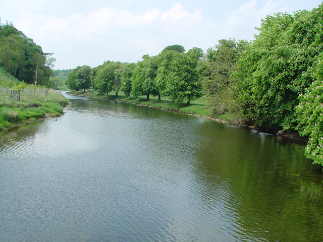
| Burnsall to Grassington | 3.7 miles (6 km) | A delightful waterside walk along the River Wharfe from Burnsall to Grassington in the Yorkshire Dales. It's a very beautiful part of the river with stunning views of Wharfedale and a visit to Linton Falls to enjoy. The route is fairly easy going, running for just a few miles along a section of the waymarked Dales Way long distance trail. You can park in the car park in Burnsall where there is also a Grade II listed grammar school building dating from 1602. The walk starts on Burnsall Bridge and follows the waymarked trail along the western side of the river to nearby Hebden. Here you cross to the other side on the suspension bridge and continue west passing Linton Church which can be reached via stepping stones when the river is low enough. Shortly after you come to the beautiful Linton Falls where there is a bridge with fine views down to the falls. The final section takes you into the town of Grassington where there are lots of nice pubs and tea rooms for refreshments after your walk. View Full Details>> | |
| Castle Bolton | 2.5 miles (4 km) | Visit the wonderful grounds of the 14th century Bolton Castle before exploring the beautiful countryside surrounding the village. It's a short walk to the castle from the village of Castle Bolton. For a fee you can explore the gardens and the maze before climbing the castle for wonderful views over the Yorkshire Dales. You can also learn about the fascinating history of the castle. Mary, Queen of Scots stayed there for six months in the 16th century. After her defeat in Scotland at the Battle of Langside in 1568 she fled to England, posing a threat to the position of the Protestant Queen Elizabeth I. After exploring the castle the walk then heads towards Low Thoresby before visiting the nearby village of Redmire. The attractive little village is the terminus of the Wensleydale Railway. The heritage railway runs 22 miles (35 km) between Northallerton West station and Redmire. It's a great way to see this beautiful area. From Redmire you cross the pretty Apedale Beck and return to the village. To extend your walking in the area you can head south west and visit the fabulous Aysgarth Falls. The falls are one of the most visited attractions of the area and are well worth a visit. The Herriot Way long distance footpath also runs through the area. The circular route takes you through areas of the Yorkshire Dales associated with the vet and author James Herriot. Head south to the River Ure and you can try our Wensleydale Walk which visits Redmire Force waterfall and the vilage of Wensley, which gives its name to the dale of Wensleydale. View Full Details>> | |
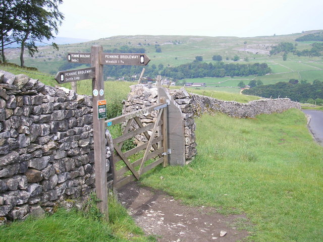
| Catrigg Force | 7.5 miles (12 km) | This circular walk visits the beautiful Catrigg Force waterfall in the Yorkshire Dales. It's a wonderful spot and can be easily reached from Stainforth. This longer walk starts at Settle and involves some more challenging hill climbing. After leaving Settle you climb towards Attimire Scar where you can see a series of caves and interesting limestone formations. You then descend to the waterfall, passing Jubilee Cave, Victoria Cave and Winskill Stones - a 74-acre area of limestone grassland and limestone pavement. The area is also a nature reserve with a wide variety of plants and wildflowers, such as sandwort, horseshoe vetch, meadow saxifrage, mossy saxifrage, mountain everlasting and moonwort. Shortly after passing through Wainskill Stones you come to Catrigg Force. The waterfall has 2 main drops of about 20 feet and a series of smaller waterfalls. It's a delightful area, with peaceful woodland and the Stainforth Beck to enjoy. The route then continues to Stainforth before picking up the Ribble Way and following the River Ribble back to Settle. This lovely waterside section also passes the Stainforth Force Waterfall. View Full Details>> | |
| Cautley Spout | 2.5 miles (4 km) | Cautley Spout is England's highest (cascade) waterfall above ground. It's located near Sedburgh in the Yorkshire Dales National Park. This walk starts at the Cross Keys public house and follows a footpath running alongside the waterfall from Low Haygarth to the top of the spout. It is a steep climb but the footpath is essentially a series of steps so it is quite an easy path to the follow. This is likely to be a very peaceful walk as the area does not attract too many visitors. Ideal if you are looking for some solitude in beautiful surroundings. You could continue your walk by climbing further over the beautiful Howgill Fells where there are magnificent views of the Lake District. Just to the west you will find the highest point of the Howgills at The Calf. You can extend your walk by heading to this great viewpoint and then following the Dales High Way to Sedbergh. If you also use the Pennine Journey long distance trail you can turn it into a longer circular walk. View Full Details>> | |
| Circular Walk in Swaledale | 11.2 miles (18 km) | This 11 mile circular walk around Swaledale takes in some of the highlights of this beautiful area of the Yorkshire Dales. On the way you'll enjoy lovely riverside sections along the River Swale, a series of pretty waterfalls and a visit to the striking Gunnerside Gill. The walk starts from the little village of Gunnerside where you will find a parking area, a pub and tea rooms for refreshments. Here you can also pick up waterside footpaths running west along the River Swale to Muker. Here you turn north and continue along the river to Catrake Force waterfall. It's a beautiful spot comprising of a series of 4 steps each with its own small waterfall. The largest single drop being about 20 feet (6.1 m). Just east of here you will soon come to the noteworthy Kisdon Force. These stunning falls drop 10 metres (33 ft) over two cascades and are surrounded by Kisdon Force Woods with mixed broad-leaved woodland including ash, wych elm and rowan trees. The route then continues east toward Gunnerside Moor. Just south of here you will pass another major highlight of the area at Gunnerside Gill. View Full Details>> | |
| Clapham Yorkshire | 2.2 miles (3.5 km) | The popular village of Clapham makes a great base for exploring the Yorkshire Dales. The village is accessible by public transport via Clapham railway station which is situated 1 mile (1.6 km) south-west of the village. Since the 18th century Clapham has been home to the Farrer family who established their Ingleborough estate. The family owns, and is responsible for, much of the land, walls, woods, fields and moors of the village, surrounding countryside and farms. The village is a popular start point for climbing Ingleborough Mountain and the fascinating glacial erratic boulders at Norber Erratics. This short walk takes you from the village to Ingleborough Cave which is situated just over a mile to the north of the village. It's a lovely area with the pretty Clapham Beck running past Clapham Lake before a peaceful woodland section through Clapdale Wood. The footpaths eventually lead to Ingleborough Cave (formerly known as Clapham Caves), a show cave adjacent to where the water from Gaping Gillresurges. That part of the cave which is open to the public follows a fossil gallery for some 500 metres (1,640 ft). The passage is spacious, and well decorated with stalagmitic formations. After exploring the cave the route returns to the village along the same paths. View Full Details>> | |
| Cotter Force | 0.6 miles (1 km) | This walk visits the lovely Cotter Force waterfall near Appersett in the Yorkshire Dales. The walk starts at the roadside parking area next to Holme Heads Bridge and follows a good footpath along the Cotterdale Beck to the falls. The falls are very pretty, comprising of six steps, each with its own small waterfall. The area is good for birdwatching too. Look out for dippers, grey wagtails, kingfishers and redstarts as you make your way along the trail. There are plenty of good options for continuing your walking in this lovely area. You could visit the nearby Hardraw Force waterfall or climb Great Shunner Fell. The Hawes Circular Walk takes you on a tour of the rivers, becks, waterfalls and hills surrounding the town. View Full Details>> | |
| Cow and Calf and Twelve Apostles | 5 miles (8 km) | This circular walk visits two of the higlights of Ilkley Moor and Burley Moor in West Yorkshire. The walk starts from the Cow and Calf parking area on Hangingstone Road, just to the south east of the town of Ilkley. From here you can pick up footpaths onto the moor, taking you to the famous 'Cow and Calf', a large rock formation consisting of an outcrop and boulder, also known as Hangingstone Rocks. The distinctive rocks are made of millstone grit and are so named because one is large, with the smaller one sitting close to it, like a cow and calf. From here you head west to meet up with the Backstone Beck. A nice footpath runs south along the beck to take you to the Twelve Apostles stone circle. The bronze age stones are an impressive sight, set in an elevated position on Burley Moor, nearly 400 metres above sea level. The circle originally had between 16 and 20 stones, but it is now reduced to 12 stones with a diameter of about 15 metres. After exploring the stones the route continues east across Burley Moor to the pretty Lower Lanshaw Dam. The path passes along the northern end of the water before linking up with the Ebor Way long distance footpath. This will then take you in a north west direction, leading you back to the car park and the finish point of the walk. Here you can enjoy well earned refreshments at the popular Cow and Calf pub. View Full Details>> | |
| Dales High Way | 90.1 miles (145 km) | This long distance waymarked walk runs for about 90 miles across the beautiful countryside of the Yorkshire Dales. View Full Details>> | |
| Dales Way | 78.3 miles (126 km) | This wonderful walk takes you through the fabulous Yorkshire Dales and on into Cumbria and the spectacular Lake District. There are several wonderful waterside stretches to enjoy starting with the River Wharfe at Ilkley before runs along the Rivers Dee and Lune soon follow. A pleasant stroll along the River Kent takes you into the Lake District National Park and then onto the finish point at Bowness. Highlights on the route include the spectacular Linton Falls, the beautiful Burnsall to Grassington section through Wharfedale and the wonderful Bolton Abbey. View Full Details>> | |
| Denby Dale | 5.6 miles (9 km) | This walk visits the village of Denby Dale in West Yorkshire. It makes use of waymarked trails to create a circular walk through the surrounding countryside. On the way there's nice views of the River Dearne and Denby Viaduct, open countryside, woodland trails and some small hill climbs with great views from the high points. The walk starts from Denby Dale railway station, located just to the east of the village. The station lies on the Penistone Line 9.5 miles (15 km) south east of Huddersfield. From here you can pick up a footpath heading south east that will link you up with the Kirklees Way long distance trail. This will lead you east to Dobroyd Hill and Upper Bagden before following woodland trails through Bagden Wood. The route then turns west past Bagden Hall and Bagden Park golf club, passing along the Dearne Way for a while. Around Kitchenroyd you turn north and then west to follow the Kirklees Way into the village of Lower Cumberworth. Trails will then take you south east to Denby Dale, before returning to the train station where the walk finishes. View Full Details>> | |
| Dent Head Viaduct | 8.3 miles (13.3 km) | This circular walk visits the impressive Dent Head Viaduct in Dentdale in the Yorkshire Dales, Cumbria. View Full Details>> | |
| Digley Reservoir | 1.6 miles (2.5 km) | Enjoy an easy circular walk around this delightful reservoir near Holmfirth in the Yorkshire Dales. There are lovely views of the surrounding moorland, woodland and countryside to enjoy as you make your way around the water. The walk starts at the good sized car park at the North Eastern end of the reservoir off Gibriding Lane. You then pick up a good footpath running along the northern end of the reservoir on the Kirklees Way. You pass Bilberry reservoir and head through Digley Wood on the southern side of the water, before returning to the car park using Fieldhead Lane. The reservoir is located about 2 miles from Holmfirth so you could start the walk from the town and follow the Holme Valley Circular Walk to the reservoir as an alternative to parking at the car park. This takes you through an area associated with the sitcom Last of the Summer Wine which was filmed in Holmfirth and the surrounding area. You could also enjoy a stroll along the Digley Brook and River Holme at the eastern end of the reservoir or follow the Kirklees Way to the nearby Brownhill Reservoir and Ramsden Reservoir. View Full Details>> | |
| Druids Temple | 9.3 miles (15 km) | Visit this fascinating replica of Stonehenge, on this lovely circular walk from Masham. The unusual folly is one of the local highlights and with a series of pleasant footpaths around the site it is a popular destination for walkers. The walk starts in the market town of Masham in the Harrogate district of North Yorkshire. The attractive town has some fine Georgian architecture and has some nice riverside footpaths along the River Ure and River Burn. From the town you head west along the Ripon Rowel long distance trail. It will take you towards Micklebury Hill and across Fearby Moor, with nice views of the River Burn. The route then climbs on to the wooded area where you will find the Druids Temple structure. It was built in about 1820 by William Danby of nearby Swinton Park. The site includes a large stone table, a sheltered cave, and an altar stone. It became a folly of national reputation and is still an impressive sight. Situated at over 800ft there are great views over Wensleydale from the Druid's Plantation surrounding the folly. After exploring the folly and the woodland, the walk then descends to High Knowle and the pretty Sole Beck before picking up the Ripon Rowel to take you back to Masham. To extend the walk you could continue west and visit Leighton Reservoir and Roundhill Reservoir. There's some nice trails along the water and up into the surrounding moorland. Around here you can also pick up the Six Dales Trail. View Full Details>> | |
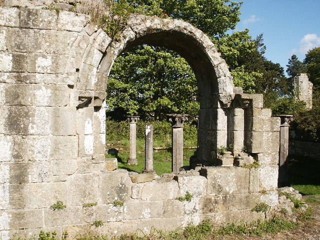
| Easby Abbey | 1.2 miles (2 km) | Visit the fascinating ruins of the 12th century Easby Abbey and enjoy a stroll along the River Swale on this easy walk in Richmondshire. View Full Details>> | |
| Embsay Reservoir | 0.9 miles (1.5 km) | Enjoy a short stroll around this reservoir in North Yorkshire. It's a lovely, quiet spot, with great views across the surrounding moors, hills and countryside. Start the walk from the car park at the south eastern end of the water. It's located at the end of Pasture Road, just to the north of the village of Embsay. You could also walk from the village, if you prefer. From the car park you can directly pick up the nice footpath running around the water. At the northern end there's a moderate climb to Crag Nook, with nice views back down to the water. To extend your walking in the area just head north east and visit the Barden Reservoirs. View Full Details>> | |
| Fountains Fell | 8.1 miles (13 km) | Climb to this prominent fell in the Yorkshire Dales and enjoy wonderful views over the surrounding hills and countryside. The circular walk starts from the beautiful Malham Tarn and climbs to the fell using a section of the Pennine Way National Trail. The route climbs to a height of 668 metres (2,192 ft) with lovely views of the pretty Fountains Fell Tarn below. At the northern tip of the route you have the option of following the Pennine Way north west to Pen y ghent, one of the famous three peaks of Yorkshire. To extend your walking in the area you can explore the Malham Tarn estate with its glacial lake and Tarn Moss Nature Reserve. There's also the climb to Gordale Scar, the fascinating Malham Cove and the beautiful Janet's Foss waterfall to visit on the estate. The route of the Settle Loop also passes just to the south west of the fell. View Full Details>> | |
| Gargrave | 5.9 miles (9.5 km) | This circular walk explores the countryside and canals surrounding this popular village in the Yorkshire Dales. The route makes use of the Pennine Way and the towpath of the Leeds and Liverpool Canal to create a 6 mile round walk. It's a fairly gentle route with little climbing and splendid views of the surrounding Yorkshire Dales hills. You can start and end the walk from the centre of the village which is accessible by train or bus. The area around Gargrave is fantastic for walking and cycling. You could head to Barnoldswick by walking south along the canal or visit the splendid Malham Tarn Estate by heading north along the Pennine Way. You can also enjoy walk along the River Aire by following the Airedale Way which passes through the village. On our Skipton Canal Walk you can follow a lovely section of the Leeds and Liverpool to nearby Skipton. View Full Details>> | |
| Gordale Scar | 4.3 miles (7 km) | This circular walk climbs to the spectacular Gordale Scar in the Yorkshire Dales. It's a popular walk through a wonderful limestone ravine with streams, waterfalls and striking geological features to enjoy. The unique area is about 16 million years old and has its own micro-climate which allows rare wildflowers and plants to thrive iin the gorge. The circular trail runs for just over 4 miles and includes some moderate climbs and a bit of a scramble around the waterfall so a reasonable level of fitness is required. You start in the pretty village of Malham and follow Gordale Lane and Gordale Beck north east to Gordale Scar. Here you will find two waterfalls and overhanging limestone cliffs over 100 metres high. It's a truly stunning sight and well worth the climb from Malham. From Gordale Scar you continue the climb towards Seaty Hill where there are magnificent views of the Yorkshire Dales. The final section descends along country lanes to Malham Village. View Full Details>> | |
| Gouthwaite Reservoir | 5 miles (8 km) | This walk takes you around this delightful reservoir, near Pateley Bridge and Ramsgill. The route makes use of the Nidderdale Way footpath which runs around the reservoir. It's a super place for birdwatching with three viewing areas on the edge of the reservoir. Look out for great spotted woodpecker and nuthatch in the trees around the water. On the reservoir you can spot goosanders, goldeney, mallard, tufted duck and pochard. Other visitors include buzzard, red kite, hen harriers, merlins and kestrels. This walk starts at the car park on the western end of the reservoir but you could also start at Pately Bridge and follow the River Nidd to the reservoir. To extend your walk you could follow the Nidderdale Way to the spectacular limestone gorge at How Stean Gorge. The Six Dales Trail also passes the through the area. If you follow if north you can cross Fountains Earth Moor and visit the nearby Leighton Reservoir. View Full Details>> | |
| Grass Wood | 2.2 miles (3.5 km) | This circular walk explores the Grass Wood Nature Reserve near Grassington in North Yorkshire. View Full Details>> | |
| Grassington | 9.9 miles (16 km) | The North Yorkshire town of Grassington is an excellent base for exploring the beautiful Wharfedale on foot. It is the main residential and tourist centre in Upper Wharfedale and a popular place for walkers. Centred on its small cobbled square are a number of shops, public houses, cafes, restaurants and hotels. There is also the fascinating Grassington Folk Museum which tells the story of the history of Wharfedale. This walk uses the Dales Way and other public footpaths to visit some of the highlights of the area. You'll enjoy riverside paths, waterfalls, rushing becks, historic houses, challenging climbs and wonderful limestone scenery. The walk starts in the centre of the town and follows the Dales Way to the River Wharfe where you pick up the riverside path. It heads south east to the beautiful Linton Falls where there is a great viewpoint from the bridge over the river. The route continues towards Hebden and Burnsall before turning north along the Fir Beck towards Skyreholme. Shortly after you come to the delightful Parceval Hall Gardens. This Grade II listed manor house has 24 acres of formal and woodland gardens to explore and is well worth a small detour from the route. The walk continues to another major highlight of Wharfedale at Troller's Gill. The wonderful limestone gorge includes the pretty Skyreholme Beck which flows through it. The final section of the walk climbs to Grimwith Reservoir. The large reservoir is another must see attraction of the area. It has a splendid circular trail running around the perimeter of the water with a wide variety of water loving birdlife to look out for. To continue your walking in the Grassington area you could head north west of the town to the Grass Wood Nature Reserve. The reserve has miles of woodland trails with lots of wildlife to look out for. View Full Details>> | |
| Grassington Circular Walk | 5 miles (8 km) | A lovely circular walk around Grassington, taking you along the River Wharfe to the village of Hebden before climbing into the countryside above the town. Along the way there's pretty weirs, waterfalls and fabulous views over Wharfdale from the high points. Starting in the town centre you head west to the river where you pick up the Dales Way long distance trail. Follow the trail east past Linton Falls to the stepping stones and suspension bridge where you cross the river. The route then follows the waters of Hebden Beck into the little village of Hebden. It's about the halfway point on the walk, so a nice place to stop for refreshments. After leaving the village you follow High Lane west through some lovely countryside. This section climbs to a height of nearly 800ft so there's great views to enjoy here. If you wish you can head north to Garnshaw House and Edge Top to go even higher. At the end of High Lane you descend back into Grassington where the route finishes. To extend your walking in the area you can try our alternative Walk around Grassington which takes you up to the lovely Grimwith Reservoir. You could also continue south along the Dales Way and visit the wonderful Bolton Abbey where there's some nice trails to follow around the atmospheric ruins of a 12th-century Augustinian monastery. View Full Details>> | |
| Grassington to Conistone Walk | 9.9 miles (16 km) | This walk takes you from Grassington to the nearby village of Conistone. On the way you'll visit the rocky outcrop of Conistone Pie and Conistone Dib, an interesting dry valley in a limestone gorge. The walk starts in Grassington where you can pick up the Dales Way long distance trail. Follow the waymarked path north from the town to Lea Green and Conistone Pie. Here you will find an unusual rock outcrop which is said to resemble an apple pie. From the elevated position of the pie there are splendid views over Wharfdale and Swineber Scar. After taking in the views the route turns south and then west to visit Conistone Dib. The dib is in a dry limestone gorge with more interesting scenery to admire. The path through the dib descends into the attractive village of Conistone where there is a stone arch bridge over the River Wharfe and a noteworthy church which dates from around the 12th century. You can turn it into a circular walk by following Grass Wood Lane south back towards Grassington. View Full Details>> | |
| Grassington to Kettlewell | 5.9 miles (9.5 km) | A linear walk on the Dales Way between these two popular Yorkshire towns. The route includes some wonderful limestone scenery and fabulous, far reaching views from the high points. It's about a 6 mile hike, with some moderate climbs along the way. You pick up the Dales Way in the centre of Grassington and head north, climbing to Lea Green, Old Pasture and Conistone Pie. This unusual limestone outcrop is shaped like a pie and commands great views of Wharfedale and Littondale. The route then descends along Swineber Scar toward Scargill House. The house dates from the eighteenth century and is constructed of stone, rendered and colour-washed, under a stone flag roof. It is now used as a Christian conference Centre run by the Scargill Movement. The route then passes Crookacre barn before coming into Kettlewell. View Full Details>> | |
| Great Shunner Fell | 8.1 miles (13 km) | Climb to the highest point in Wensleydale on this popular walking route in the Yorkshire Dales National Park. The route begins at the village of Hardraw near to the lovely Hardraw Force Walk waterfalls. It then follows the Pennine Way National Trail to the fell top which lies about 4.5 miles north of the village. As such the path is well defined and way-marked. The route continues along the trail to Thwaite where there is an old bridge and some waterfalls. You can turn it into a circular walk by following the Cliff Gate Road south if you prefer. There are fabulous views from the summit of Wensleydale to the south, Ribblesdale to the south west and Swaledale to the north, as well as views into Cumbria and County Durham. To extend your walking in this lovely area you could pick up the 10 mile Hawes Circular Walk which takes you on a tour of the rivers, becks, waterfalls and hills surrounding the town. View Full Details>> | |
| Great Whernside | 4 miles (6.5 km) | Climb to this prominent fell on this walk from Kettlewell to Great Whernside in North Yorkshire. Great Whernside forms the watershed between Wharfedale and Nidderdale, and is on the boundary between the Yorkshire Dales National Park and Nidderdale Area of Outstanding Natural Beauty. You can ascend to the 704 m (2,310 ft) summit from the village of Kettlewell. It's about a 2.5 mile climb and considered by many to be one of the best in the Yorkshire Dales. From the summit there are wonderful views of Pen y ghent, Ingleborough, Whernside, Pendle Hill and the Lake Distirct Mountains. This route climbs to the summit directly from Kettlewell, following a footpath to Hag Dike and then on to the summit. You can turn it into a longer circular route by continuing north from the summit to Blackfell Top and Black Dike and then descending to Starbotton Road. See our Circular Walk around Kettlewell for more details. Kettlewell is a pretty little village with a car park where you can start the walk. After your walk there's good pubs and cafes where you can refresh yourself after your exercise. There's lots of good options for extending your walking in the Kettlewell area. The Dales Way runs through the village so you could pick up the long distance path and head south to the market town of Grassington. Here you can enjoy riverside paths along the River Wharfe and a visit to the pretty Linton Falls. Just to the north is the village of Buckden where you can climb to Buckden Pike. View Full Details>> | |
| Grimwith Reservoir | 4 miles (6.5 km) | Enjoy a circular walk around this lovely reservoir in the Yorkshire Dales. There is a good footpath running around the reservoir with fabulous views of the surrounding countryside. The reservoir is great for bird watching, look out for wildfowl including wigeon, teal, greylag geese and Canada geese on the water. Other winged visitors to the area include ringed plover, northern lapwing, common redshank, curlew, reed bunting, lesser redpoll, whinchat and sedge warbler. The walk starts at the car park at the southern end of the reservoir and heads to Grimwith Moor, crossing Grimwith Beck on the way. You continue to Bracken Haw, cross the pretty Blea Gill and then pass Hebden Moor. The final section passes Hartlington pasture before returning to the car park. If you'd like to continue your walking in the area then you could head to the nearby Linton Falls. Just to the south is the wonderful limestone gorge at Troller's Gill. The reservoir is located close to Grassington and could be reached by following the Dales Way and other footpaths from the town. View Full Details>> | |
| Gunnerside Gill | 5 miles (8 km) | This circular walk in Swaledale takes you through the lovely Gunnerside Gill. It's a beautiful valley with imposing scars, woodland, waterfalls and the pretty Gunnerside Beck running through the centre. View Full Details>> | |
| Hardraw Force Walk | 0.6 miles (1 km) | This walk takes you to the beautiful Hardraw Force waterfall in the Yorkshire Dales. Access to the waterfall is through the 13th century Green Dragon Inn for a small fee. It's worth the fee as the waterfall is England's highest single drop waterfall, falling some 100ft. A footpath takes you through ancient woodland and along the Hardraw Beck to the falls. The falls are in a lovely spot set in the spectacular narrow gorge of Hardraw Scaur. The area includes a new Heritage Centre with information about the falls and facilities such as toilets, showers and a cafe. There's plenty of good options for continuing your walking in the area. You could head to the nearby Cotter Force waterfall where you'll find another good footpath leading to these pretty falls. The Pennine Way also runs past Hardraw so you could pick this up too. The 10 mile Hawes Circular Walk takes you on a tour of the rivers, becks, waterfalls and hills surrounding the town. It visits Hadraw Force so you could pick up the trail to continue your walk. View Full Details>> | |
| Harmby Waterfall Walk | 0.6 miles (1 km) | This short walk explores the pretty waterfall at Harmby in the Lower Wensleydale area of the Yorkshire Dales. This hidden gem is located just off the A road east of Leyburn. It's a very peaceful spot which is particularly impressive after heavy rain. It's located just opposite the Pheasant Inn with a path leading down to the falls. There's another well maintained footpath to follow a short distance with the falls surrounded by attractive foliage. Afterwards you can enjoy a little stroll around the village where there's nice old stone cottages and a delightful little stream running through the centre. You could also head out into the countryside on some of the public paths branching off from the village. View Full Details>> | |
| Hawes | 9.9 miles (16 km) | This circular walk around the market town of Hawes visits three lovely waterfalls and takes you through some beautiful Yorkshire countryside. The town is in a great location for walkers with the lovely scenery of the Yorkshire Dales and some good waymarked footpaths to follow. The walk makes use of the Pennine Way and other public footpaths to visit Hardraw Force, Cotter Force and Aysgill Force waterfalls. The 10 mile route starts in the centre of the town and heads north, crossing the River Ure, before climbing along Hardraw Beck to Hardraw Force Waterfall. The impressive waterfall is England's highest single drop waterfall, falling some 100ft. Access to the waterfall is through the 13th century Green Dragon Inn. The route then climbs west to Bluebell Hill, reaching a height of over 1000ft and providing great views over the surrounding area. From here you descend back to the River Ure, where you head west along the river to Cotterdale Beck and on to Cotter Force Waterfall. The falls are very pretty, comprising of six steps, each with its own small waterfall. From here you head back along the river to Appersett, where you follow the Widdale Beck towards Appersett Viaduct. The route then heads back towards Hawes where you can take a detour south along the Gayle Beck to visit Aysgill Force Waterfall. There's lots of other nice walks to try in the Hawes area. You could try the climb to the splendid Great Shunner Fell. The hill is the highest point in Wensleydale and can be climbed from the village of Hardraw which this walk visits. A few miles to the south east of the town you can visit the lovely Semer Water. View Full Details>> | |
| Hawes to Snaizeholme Walk | 4.3 miles (7 km) | This walk takes you from Hawes to Snaizeholme and the lovely red squirrel trail. View Full Details>> | |
| Herriot Way | 49.7 miles (80 km) | This long distance circular route takes you through areas of the Yorkshire Dales associated with the vet and author James Herriot. The walk begins in the pretty village of Aysgarth in Wensleydale. Here you can admire the wonderful Aysgarth Falls before following the River Ure to Askrigg. The village was used as the fictional Darrowby in the BBC TV series All Creatures Great and Small, based on the books by James Herriot. Just above Askrigg you can visit the lovely Mill Gill and Whitfield Force Waterfalls. After leaving Askrigg you continue to the village of Hardraw where you will find the splendid Hardraw Force Waterfall. The waterfall is England's highest single drop waterfall, falling some 100ft. The route then heads to the market town of Hawes before climbing Great Shunner Fell. It is the highest point in Wensleydale and commands wonderful views over Ribblesdale to the south west and Swaledale to the north, as well as views into Cumbria and County Durham. You descend the mountain to Thwaite and then on to the village of Keld where you will find the beautiful Kisdon Force, East Gill and Catrake Force waterfalls. From Keld you continue across Gunnerside Moor, passing the beautiful valley of Gunnerside Gill. It's a lovely area with a fascinating lead mining history. You can still see several ruined buildings from the period including the remains of Blakethwaite Smelt Mill and the old mine offices. The walk continues east to Healaugh, passing along Mill Gill. You then follow the River Swale into Reeth. You continue to Castle Bolton passing through open moorland with lots of pretty heather. View Full Details>> | |
| Hoffman Kiln Walk | 3.9 miles (6.2 km) | This circular walk visits the Hoffman Kiln in Stainforth, Yorkshire. View Full Details>> | |
| How Stean Gorge | 3.1 miles (5 km) | Visit this spectacular limestone gorge and enjoy a walk through the beautiful Nidderdale countryside. You can park in the village of Middlesmoor and then follow footpaths to the gorge about half a mile south. It's great for walkers with lots of public footpaths along the rushing river and through the surrounding woodland. The area also has an activity centre where you can try caving, rock climbing, abseiling and canoeing. After exploring the gorge you could extend your walk by picking up the Nidderdale Way and following it to the nearby Gouthwaite Reservoir or Scar House Reservoir. View Full Details>> | |
| Hutton Roof Crags and Farleton Fell | 5.3 miles (8.5 km) | Explore some of the finest limestone pavement in the country on this climb to Hutton Roof Crags and Farleton Fell. The scenery is striking with boulders and unusual rock formations covering the landscape. You'll pass across Hutton Roof Crags and climb over Newbiggin Crags before reaching the high point at Farleton Knot. All the way there are magnificent views over the surrounding fells. The area is also a nature reserve with a wide variety of interesting flora and fauna. Look out for fly orchids, lily of the valley and dark red helleborine. Wildlife includes small tortoiseshell and brimstone butterflies with birdlife such as woodpecker, long-tailed tits, redwing, fieldfare and mistle thrush. You may also see roe deer. This circular walk starts in the village of Hutton Roof and follows the Limestone Link over Hutton Roof Crags and Newbiggin Crags before reaching the high point at Farleton Knott. From here there are fabulous views over the Lake District and the Yorkshire Dales. The route then follows country lanes and other footpaths back to Hutton Roof. Hutton Roof Crags is located a couple of miles west of Kirkby Lonsdale. You could start the walk from here and follow the Limestone Link to the crags. To extend your walking in the area you could pick up the Lune Valley Ramble and enjoy a riverside stroll along the River Lune. Also nearby is the beautiful Barbondale where there is a nice walk to Calf Top Hill and along the Barbon Beck. View Full Details>> | |
| Ilkley Moor | 5 miles (8 km) | Visit this geologically fascinating area of West Yorkshire on this challenging and atmospheric circular walk on Ilkley Moor. The moor is in an elevated position above the town with attractive moorland and wonderful views over the surrounding countryside. It's a beautiful place with pretty heather in the summer and a myriad of different footpaths to follow. Ilkley Moor is located just to the south of the town of Ilkley so you could easily reach it from the bus or train station in the centre of the town. Then follow the Dales Way Link south to take you onto the moor. This route, however, starts from the Cow and Calf car park on Hangingstone Road. Near here you will find the well known Cow and Calf rocks. This striking rock formation consists of a large rock and a smaller one, sitting next to each other like a cow and its calf. From the rocks follow the paths west across the moor to Cranshaw Thorn Hill and Keighley Road, where you turn south to Whetstone Gate. The route then turns east to take you to another of the major landmarks on the moor. The Twelve Apostles is a fascinating Bronze Age stone circle with 12 stones made from the local millstone grit. After leaving the Twelve Apostles you head north back towards the car park passing the Backstones stone circle on the way. After your exercise you can enjoy refreshments at the excellent Cow and Calf pub. View Full Details>> | |
| Ilkley Riverside Walk | 5.9 miles (9.5 km) | This walk follows the Dales Way and the River Wharfe from Ilkley to Addingham and Bolton Abbey. The route runs along a lovely section of the river with great views of the surrounding Yorkshire Dales countryside to enjoy on the way. It's about a 6 mile walk on fairly flat, waymarked footpaths. The walk starts in the pretty Riverside Gardens on the south bank of the river. Here you will also find Ilkley Roman Fort where you can see the remains of the outer walls near the town's old Manor House Art Gallery & Museum. Follow the path west past the Old Bridge and Ilkley Golf Club and you will come to Addingham. You continue north through the pretty Low Park before passing Bolton Bridge and arriving at Bolton Abbey. The 12th-century Augustinian monastery is surrounded by lovely woodland and parkland. There's also miles of riverside trails with a series of popular stepping stones to try as well. View Full Details>> | |
| Ilkley to Addingham | 5.3 miles (8.5 km) | This circular walk takes you from Ilkley to Addingham along the River Wharfe. It first uses a section of the Dales Way long distance trail to take you along the river to Addingham. Here you can cross the Wharfe on a Suspension Foot Bridge and return through the countryside via Nesfield, Low Austby and Owler Park. The route is just over 5 miles with some moderate climbs on the return leg. The walk starts from the Roman Fort in the Victorian spa town of Ilkley. A wall, once part of the fort, can still be seen near the town's old Manor House Art Gallery & Museum. From here you can pick up the Dales Way and follow it north west along the river to Addingham. You could head into the village and stop for refreshments at one of the pubs or cafes, at what is roughly the half way point of the route. This walk crosses the river and climbs past the Castleberge Fort. Thought to be an iron age fort (but never properly investigated), it sits atop a sizeable natural hill at a bend in the River Wharfe. From here you continue to Nesfield and Low Austby where you head through the woodland of Owler Park before descending back to the river and the town. View Full Details>> | |
| Ingleborough Mountain | 8.1 miles (13 km) | This walk climbs to Ingleborough, one of Yorshire's Three Peaks, standing at a height of 723 metres (2,372 ft). This circular walk starts in the village of Clapham and takes you along Clapham lake to Clapdale Woods. You continue along Clapham Beck toward Ingleborough Cave. You can take a short detour from the route to visit this show cave which has a long fossil gallery and interesting stalagmitic formations. From the cave you continue to Trow Gill where you will pass through a lovely, wooded limestone ravine before reaching Gaping Gill natural cave. You continue north to the summit where there are fantastic views over the Yorkshire Dales. The descent takes you through Newby Moss to Newby Cote where you pick up a country lane which takes you back to Clapham . If you'd like to continue your walking in the area then you could try climbing the other two of the Yorkshire Dales three peaks:-Pen y ghent and Whernside. On the southern slopes of Ingleborough you will find the fascinating Norber Erratics. The geologically significant set of glacial boulders were probably deposited by melting ice sheets at the end of the last ice age, around 12,000 years ago. They can be reached by heading south from Sulber Nick to Moughton Scar and Crummack Dale. You can also approach the mountain from the north from the famous Ribblehead Viaduct on our Whernside, Ingleborough Circular Walk. This route climbs to the summit via Park Fell and Simon Fell before heading to nearby Whernside. View Full Details>> | |
| Ingleborough Walk from Clapham | 7.5 miles (12 km) | This walk climbs to Ingleborough Cave and Ingleborough Mountain from the Yorkshire village of Clapham. It's a challenging 4 mile hike to the top of the mountain from the village centre. The walk starts in the village and heads north on a nice footpath running along Clapham Beck. There's also a pretty artifical lake and some peaceful woodland trails on this opening section. The route then passes the famous Ingleborough Show Cave before ascending to Gaping Gill. This natural cave is one of the unmistakable landmarks on the southern slopes of the mountain. The cave is a striking 98-metre (322 ft) deep pothole with the stream Fell Beck flowing into it. The next stage takes you past Little Ingleborough before continuing to the Ingleborough summit. At (723 m or 2,372 ft) it is the second-highest mountain in the Yorkshire Dales. It's located in the south-western corner of the Yorkshire Dales, at the highest point of a triangle of land with corners at Ingleton, Ribblehead and Settle. The hill is connected to its nearest higher neighbour, Whernside, by a low col or mountain pass at Ribblehead at approximately 971 feet (296 m). View Full Details>> | |
| Ingleton Falls | 4.5 miles (7.2 km) | One of the loveliest walks in England, this circular trail visits a series of beautiful waterfalls in Ingleton in the Yorkshire Dales. The walk runs for a distance of roughly 4.5 miles, with some moderate climbing on the way. The walk starts at the car park in Ingleton and follows the River Twiss through the woodland of Swilla Glen. You then cross the river at Manor Bridge and soon come to Pecca Falls. These falls consist of five main waterfalls dropping 30 metres over sandstone and slate into deep plunge pools. You then climb to Hollybush Spout, before coming to the spectacular Thornton Force. Here you will find a viewing area where you can watch the river plunge 14 metres over a cliff of limestone. From Thornton Force you head to Ravenray Bridge where you cross the river and begin the return leg. This starts by following Twisleton Lane to Twisleton Hall and Beezley Farm. Here you pick up the River Doe to Beezley Falls and Triple Spout – three beautiful waterfalls all side by side. You continue south along the river passing Rival Falls, and Baxengyhll Gorge where there is a viewing platform with fabulous views of the river and Snow Falls. The final section takes you into the pretty village of Ingleton and then on to the finish point at the car park. The Richmond Way long distance walk passes through Ingleton so you could pick this up to continue your walking in the area. You could also head east and visit the village of Clapham where there's a lovely walk along the Clapham Beck to the fascinating Ingleborough Show Cave. View Full Details>> | |
| Janet's Foss | 1.9 miles (3 km) | Visit this lovely waterfall on this short walk on the National Trust's Malham Tarn Estate. The falls are located just over a mile from the village of Malham. You can pick up a nice footpath which climbs alongside a pretty beck and through garlic scented woodland to the falls for just over a mile. To turn it into a circular walk you could return on Gordale Lane, on the western side of the falls. It's a popular and fairly easy walk, on well surfaced footpaths so great for families with kids. It's well signposted, taking you along Malham Beck and the rushing waters of Gordale Beck. There's also some attractive waterside woodland trails and great views of the surrounding countryside to enjoy. You can extend your walk by continuing along the path to the wonderful Gordale Scar with its limestone cliffs and waterfalls. Continue north and you will soon come to Malham Tarn where there are walking and cycling trails around a large, glacial lake. The Settle Loop circular walking trail passes just to the west of Malham village so this is another good way of exploring the area. View Full Details>> | |
| Jervaulx Abbey | 2 miles (3.2 km) | This walk explores the photogenic ruins of the historic Jervaulx Abbey in North Yorkshire. View Full Details>> | |
| Kilnsey Crag | 1.9 miles (3 km) | This circular walk visits a striking limestone cliff in the village of Kilnsey in Wharfedale. Start the walk near Conistone Bridge where there is a parking area. From here you can follow a footpath north west towards Scar Lathe and Kilnsey Crag. The route then takes you south west down Mastiles Lane which is an old Roman Road. It can be followed all the way to Malham Tarn with full details on the Mastiles Lane Route. This route, however, turns east along the How Gill. This will lead you across Kilnsey Park back to Conistone Bridge. The walk circles around the Kilnsey Park which has a number of attractions to visit. These include a trout farm and nature trails with with wildlife such as red squirrels, angora goats, alpacas and butterflies to look out for on the way. There's also the Café by the Lake where you can relax outside and enjoy fine views over the Yorkshire Dales while enjoying a good home cooked dish from the menu. View Full Details>> | |
| Kirkby Lonsdale | 5.3 miles (8.5 km) | Enjoy a circular walk around this popular Cumbrian town. Kirkby Lonsdale sits on the western edge of the Yorkshire Dales National Park, within the beautiful Lune Valley. It's a delightful place and home to 'Ruskin's View'. He described the view of the River Lune from the churchyard as 'One of the loveliest views in England'. It was painted by J.M.W Turner in the early 19th century. The town is a great base for walkers looking to explore the Cumbrian section of the Yorkshire Dales. This walk starts in the town centre and head's to Devil's Bridge over the Lune. The wonderful 14th century bridge is a grade I listed structure and a Scheduled Ancient Monument. It's a very picturesque spot with the ancient bridge giving lovely views of the river below. At the old bridge you pick up the Lune Valley Ramble long distance waymarked path to take you south along the river towards Nether Burrow. Here you turn north west to the Lancashire village of Whittington. The pretty village has an old church and quaint cottages. The final section of the walk takes you past Whittington Hall and Sellet Hall before returning to the town. View Full Details>> | |
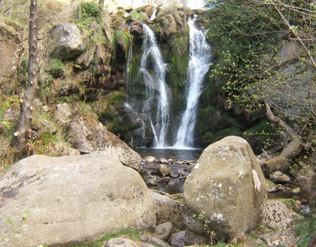
| Kisdon Force | 5 miles (8 km) | This walk visits the stunning Kisdon Force, East Gill and Catrake Force waterfalls in the Yorkshire Dales National Park. The walk begins in Keld and first heads to the nearby Catrake Force. It's a beautiful spot comprising of a series of 4 steps each with its own small waterfall. The largest single drop being about 20 feet (6.1 m).
You then head to East Gill Force - it has two main torrents: the upper falls have an impressive 4.5 metre drop whilst the lower section is a series of stepped cascades that fall three metres as East Gill enters the River Swale. The walk continues east to Kisdon Force waterfalls. These stunning falls drop 10 metres (33 ft) over two cascades and are surrounded by Kisdon Force Woods with mixed broad-leaved woodland including ash, wych elm and rowan trees. The walk then continues along the River Swale towards Muker, passing more pretty waterfalls along the way. You return on the eastern side of the river to Keld. This is a lovely, fairly easy walk with river views, waterfalls, and woodland. The Pennine Way walking trail runs past the falls so you could pick this up if you wanted to continue your walk. Also nearby is the fascinating Gunnerside Gill. Our Circular Walk in Swaledale visits the falls and Gunnerside Gill from the village of Gunnerside. There's also the Muker to Keld Walk, another circular route which visits the waterfalls and uses a section of the Pennine Way long distance trail. The video below shows a similar route but this time starting from Muker. The walk below starts from Keld for more direct access to the falls. View Full Details>> | |
| Knaresborough Round | 19.9 miles (32 km) | This 20 mile circular walk takes you on a tour of the countryside, lakes, rivers, woodland and villages surrounding the historic Yorkshire town of Knaresborough. It's a great way to explore this beautiful part of North Yorkshire. The walk starts by the River Nidd near Knaresborough Castle in the town centre. You then follow the river east towards the village of Goldsborough, home to the Grade II* listed Jacobean mansion of Goldsborough Hall. Woodland sections through Great Wood and Parsonage Wood take you to Flaxby and Coneythorpe. The route continues through several small villages around Farnham including Ferrensby, Occaney, Brearton and Scotton where you will enter the wonderful Nidd Gorge. The beautiful river gorge is a real highlight on the walk with lots of interesting flora and fauna to look out for. The final section takes you towards Starbeck and Gallow Hill before returning to the town. This walk joins with the Harrogate Ringway so you can pick up this trail to further explore the area. View Full Details>> | |
| Leighton Reservoir | 6.2 miles (10 km) | This circular walk visits Leighton and Roundhill Reservoirs before climbing into the surrounding moors for great views back down to the water. You can start the walk from the roadside parking near the bridge and then follow paths along the woodland to Roundhill Reservoir. The route then climbs onto Arnagill Moor, where you will reach a height of over 1200ft. From these high points there are splendid views over the beautiful countryside of Nidderdale. The route then descends through Head Moor before returning to the reservoirs. You could start the walk from nearby Masham if you prefer. Then follow the Ripon Rowel west along the River Burn to the reservoir. The reservoir is located very near to the fascinating Druids Temple. This replica of stonehenge sits on a hill just to the east of the start point for this walk. It's well worth a visit if you have time. The long distance Six Dales Trail also passes the reservoirs. You can pick this up and follow it south across Fountains Earth Moor and visit Gouthwaite Reservoir to extend your exercise. Around here you can also pick up the Nidderdale Way and further explore this lovely area. View Full Details>> | |
| Leyburn | 3.6 miles (5.8 km) | The market town of Leyburn has some lovely trails to follow through beautiful Wensleydale in North Yorkshire. This circular walk from the town visits the pretty little village of Wensley with a riverside section along the River Ure. There's lovely views of the surrounding Yorkshire Dales countryside and a nice country pub in Wensley to visit. Start the walk from Low Wood Lane just to the south west of the main parking areas in the town. Follow the lane south and it will lead you to the river. You can then pick up the riverside path heading west along the Ure to Wensley. The village gives its name to the dale Wensleydale and includes a Grade I listed church dating from 1300. There's also an attractive village green and rows of pretty stone cottages. You can stop for refreshments at the Three Horse Shoes pub where there are great views looking over lower Wensleydale from the beer garden. After exploring Wensley you can follow footpaths back through the countryside to Leyburn. View Full Details>> | |
| Leyburn Shawl Walk | 5 miles (8 km) | This circular walk explores the Leyburn Shawl limestone escarpment in Wensleydale. It's an interesting and attractive area with fine views from the elevated position of the Shawl. The walk starts from the western side of of the market town of Leyburn, next to Leyburn Hall. From here you can pick up a public footpath heading west up onto the Shawl. Here you'll find woodland sections, benches and open areas with wonderful views across the Yorkshire Dales. It's a good path running for two miles to Tullis Cote. Here you turn south, passing waterfalls, before crossing Wensley Park to enter the little village of Wensley. In the village you can enjoy a stroll down to Wensley Bridge and enjoy nice views of the River Ure. From Wensley you pick up a footpath heading north east, which will take you back into Leyburn where the route finishes. View Full Details>> | |
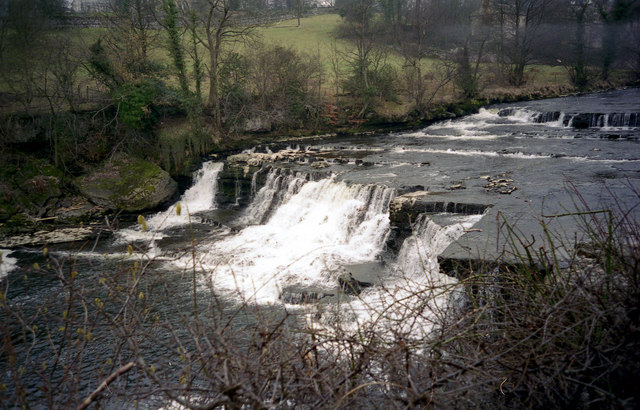
| Linton Falls | 3.1 miles (5 km) | This popular walk from Grassington visits the spectacular Linton Falls in the Yorkshire Dales. You start off in the lovely village of Grassington and soon join the River Wharfe for a waterside stroll which takes you past the falls. There is a bridge across the river which affords fabulous views of the falls below. The route returns to Grassington through countryside footpaths. If you'd like to continue your walking in the area then you could pick up the Dales Way and head along the River Wharfe through the beautiful Wharfedale. Also nearby is the delightful Grimwith Reservoir which has a walking path around its perimeter. Just a few miles to the east is the wonderful limestone gorge at Troller's Gill. View Full Details>> | |
| Malham Cove | 8.7 miles (14 km) | This super walk visits two well known beauty spots in the Yorkshire Dales. The hike to the cove and tarn is one of the most popular walks in Yorkshire. The cove was exposed to a global audience when featured in the flim 'Harry Potter and the Deathly Hallows (Part 1)'. It was used as the hideout for Harry and Hermione when they fled there to avoid capture. It begins at the village of Malham and follows the Pennine Way to the stunning Malham Cove. View Full Details>> | |
| Malham Tarn Estate | 4.3 miles (7 km) | This beautiful spot in the Yorkshire Dales is perfect for a safe cycle or walk. It is run by the National Trust and consists of a beautiful glacial lake, limestone pavements, upland hill farms and flower-rich hay meadows. There are also delightful waterside paths along the tarn and a National Nature Reserve with a bird hide and rare plants. For cyclists there is a nice, easy family cycle trail and more challenging routes for mountain bikers. There are different routes for walkers with a stroll along the shores of Malham Tarn, through the National Nature Reserve and across the fields a favourite. The Settle Loop circular trail passes close to the estate so you could follow the route from the town to the estate. Alternatively there is a good sized car park just south of the tarn. The Pennine Way passes through the estate so you could pick up the trail to extend your walking in the area. If you head south you can visit the nearby Malham Cove. The site includes a hugely impressive curved cliff formation of limestone rock. Climbing north along the Pennine Way will take you to Fountains Fell and Fountains Fell Tarn with magnificent views over the area. View Full Details>> | |
| Masham | 4.3 miles (7 km) | A circular walk exploring the countryside and rivers around the small town of Masham in North Yorkshire. The walk includes lovely riverside stretches along the River Burn and the River Ure. You'll also pass close to the Swinton Estate with its deer park and expansive parkland. The route starts in the town centre which includes a nice Market Place and some fine Georgian architecture. You head east from the town to the River Ure, where you pick up a nice riverside footpath. After about half a mile you turn west to pick up a trail along the River Burn. The river passes close to the village of Swinton which includes Swinton Park. The country house is now a hotel set in 200 acres of parkland, lakes and gardens. You can visit the estate, explore the beautiful gardens and watch out for the resident fallow deer. The walk continues past Swinton Moor before picking up a section of the Ripon Rowel long distance trail. You follow the waymarked trail through the countryside to return to the town. To extend your walking around Masham follow footpaths north from the town to the nearby Marfield Wetlands Nature Reserve. The peaceful reserve is home to a variety of species of bird and includes several ponds located next to the River Ure. If you head south you can visit Hackfall Woods and the villages of Grewelthorpe and Kirkby Malzeard. Other walks in the area include the splendid climb to the fascinating Druids Temple. You can follow the Ripon Rowel from the town to the site, where you will find an early 19th century replica of Stonehenge surrounded by attractive woodland. Also near the town is Leighton Reservoir and Roundhill Reservoir. View Full Details>> | |
| Mastiles Lane | 5.7 miles (9.2 km) | This cycle or walk takes you along the historic Mastiles Lane Roman Road from the village of Kilnsey to Malham Tarn. The lanes is a former Roman marching road, later an important route for monks leading sheep from Fountains Abbey to summer pasture on higher ground. The route runs for about 6 miles with a moderate climb at the start. If you are cycling then a mountain bike is probably best and you may have to walk some of the rougher sections. The route starts in the village of Kilnsey in lovely Wharfedale. The lane starts in the village and heads east past Kilnsey Park which has a number of attractions to visit. These include a trout farm and nature trails with with wildlife such as red squirrels, angora goats, alpacas and butterflies to look out for on the way. The lane continues across Kilnsey Moor, passing the site of an old Roman Camp on the way. Shortly after passing Seaty Hill you come to Malham Tarn where the route finishes. View Full Details>> | |
| Middleham | 6.8 miles (11 km) | This circular walk takes you around the countryside surrounding the North Yorkshire village of Middleham. There's much to enjoy with a visit to the Middleham Gallops, Coverham Abbey, riverside paths along the River Cover and the atmospheric ruins of Middleham Castle. The walk starts in the centre of the village and soon comes to the fascinating 12th century castle. The castle was the childhood home of Richard III and also owned by Richard Neville, 16th Earl of Warwick, known to history as the 'Kingmaker', a leading figure in the Wars of the Roses. For a fee you can explore the castle and learn about the history through interesting exhibitions. You can also enjoy wonderful views of Wensleydale from the elevated viewing platform. After passing the castle the route heads west on footpaths across Middleham Low Moor. This section rises to a height of over 700ft so there are more great views to enjoy here. It is also known as the 'gallops' as it is where racehorses are taken for training from one of the many stables in the village. At Fern Gill you turn south towards Tupgill Park. Also known as 'The Forbidden Corner' the park includes a herb garden and fish temple. The route continues east to Coverham where you will pass the ruins of the 12th century Coverham Abbey. The surviving remains include the ruins of the church, the guesthouse, the gatehouse and several tomb covers with effigies of knights, from the 14th century. The route then heads along the River Cover with woodland trails along the river. You then turn north to return to the village. View Full Details>> | |
| Mill Gill and Whitfield Force Waterfalls | 2.2 miles (3.5 km) | Just above the little village of Askrigg in Wensleydale there is a lovely walking trail along a river with a series of pretty waterfalls and peaceful woodland. This walk starts in the village and follows the footpath to Mill Gill Force and Whitfield Force falls before returning through some beautiful Yorkshire Dales countryside. It's a really pleasant area with good signed paths, the sound of the running water and nice shady woodland. The long distance Herriot Way runs through the village. It takes you through areas of the Yorkshire Dales associated with the vet and author James Herriot. You can pick it up to extend your walking in this lovely area. View Full Details>> | |
| Muker to Keld Walk | 6.8 miles (11 km) | This fine circular walk runs from Muker to Keld in the Yorkshire Dales National Park. On the route you'll enjoy waterside paths along the River Swale and visit a series of beautiful waterfalls. The walk starts in the village of Muker, located at the western end of beautiful Swaledale in North Yorkshire. From the car park you can pick up paths heading north towards the river, passing through the beautiful Muker Meadows which are covered in beautiful wildflowers during the summer months. Riverside paths then take you up to West Arn Gill, Bracken Hill and Kisdon Force Waterfall. These stunning falls drop 10 metres (33 ft) over two cascades and are surrounded by Kisdon Force Woods with mixed broad-leaved woodland including ash, wych elm and rowan trees. After enjoying the falls the route continues past East Stonesdale to Catrake Force. It's another photogenic spot, comprising of a series of 4 steps each with its own small waterfall. The largest single drop is about 20 feet (6.1 m). You continue along the path to Currack Falls or just cross the bridge to Keld. The village is the crossing point of the Coast to Coast Walk and the Pennine Way long-distance footpaths at the head of Swaledale. If you'd like to stop for refreshments then a tea room and small shop operate at Park Lodge from Easter to autumn. Out of season, local volunteers provide a self service café for visitors in the village’s Public Hall. In Keld you can pick up the Pennine Way to return to Muker. The waymarked trail will lead you south past Birk Hill and North Gang Scar before coming into Muker where the walk finishes. View Full Details>> | |
| Norber Erratics | 1.9 miles (3 km) | This walk climbs to this geologically significant set of glacial erratic boulders in the Yorkshire Dales. The Norber erratics can be reached from the nearby village of Austwick. It's a short but quite challenging climb from the village to the rocks which are situated on the southern slopes of Ingleborough Mountain. The fascinating boulders were probably deposited by melting ice sheets at the end of the last ice age, around 12,000 years ago. The walk exposes you to some fine limestone scenery with wonderful views to be enjoyed from the high points. The boulders are dramtically placed with the far reaching dales scenery making a striking backdrop for any photographer. This walk starts in Austwick and takes you north to the boulders on good footpaths. You could also start from the nearby village of Clapham. The walk can be extended by heading north to Thwaite Scars, Crummack Dale and Moughton Scars. Just to the north of Moughton Scars you can pick up the trail to Ingleborough Mountain at Sulber Nick. After your exercise you can refresh yourself in the local pub in Austwick. To further extend your walking in the area you can head west to Clapham where you can enjoy a stroll along Clapham Lake and Clapham Beck to the wonderful Ingleborough Show Cave. See our Clapham Walk for full details. View Full Details>> | |
| Pateley Bridge Circular Walk | 11.2 miles (18 km) | This circular walk around the Yorkshire town of Pateley Bridge makes use of the Nidderdale Way to take you on a tour the countryside, reservoirs, rivers and woodland surrounding the town. It's just over 12 miles in length so it's one you can complete in a day. The town is an excellent base for walks in the Nidderdale area. It is also home to the oldest sweet shop in England and the fascinating Nidderdale Museum. The route starts in the centre of the town and follows the River Nidd north to Gouthwaite Reservoir, passing the village of Wath-in-Nidderdale on the way. The path then heads along the water to Ramsgill with great views across the reservoir. Gouthwaite is very popular with birdwatchers with goosanders, goldeney, mallard, tufted duck and pochard to look out for on the water. At Ramsgill you will find the Yorke Arms, a Michelin-starred restaurant on the village green. Here you turn south along the western side of the reservoir to Heathfield. The walk then heads along the pretty Ashfold Sidebeck towards Pinnacle Hill. On this section of the walk you reach a height of almost 1000ft so there are some really wonderful views over the Yorkshire Dales to enjoy. The final section descends past Pincher Hill with a short woodland section here also. Shortly after you return to the finish point back in Pateley. There are many other great walks around Pateley Bridge to try. You can pick up the Six Dales Trail and explore Wharfedale, Washburndale, Colsterdale, Coverdale, and Wensleydale. The Bewerley Industrial Heritage Trail also passes through Pateley. The fascinating trail explores nearly a thousand years of lead mining history. View Full Details>> | |
| Pen y ghent | 5.6 miles (9 km) | Climb to the 694 m (2,277 ft) summit of Pen y ghent on this challenging circular walk in the Yorkshire Dales. Pen y ghent is probably the most famous and popular of the Yorkshire Three Peaks. The others are Ingleborough and Whernside. This route is the classic ascent from Horton in Ribblesdale via Brackenbottom Scar. It runs for just under 6 miles and includes a challenging ascent of over 1300ft. You start in the village of Horton in Ribblesdale at the car park and follow country lanes towards Brackenbottom. You continue the ascent, picking up the Pennine Way just before reaching the summit. From here there are fabulous views across the Yorkshire Dales. The descent follows the Pennine Way passing Tarn Barn, Horton Scar and Hull Point - the largest natural hole in England. The mountain is located close to the Malham Tarn Estate where you can enjoying cycling and walking trails around the beautiful glacial lake and try another challenging climb to Fountains Fell and Fountains Fell Tarn. View Full Details>> | |
| Ravenstonedale | 3.7 miles (6 km) | There are lots of nice walks to try around the pretty Cumbrian village of Ravenstonedale. The village sits within the Yorkshire Dales National Park on the watershed between the River Lune and River Eden. There's lovely views of the Howgills, riverside paths, limestone pavements and challenging hill climbs to try in this beautiful area. This circular walk starts in the village and heads north along the Scandal Beck to the picturesque Smardale Bridge. You continue along the beck to the impressive Smardale Gill Viaduct. The viaduct is 710 ft (220 m) long and 130 ft (40 m) high. It is surrounded by a delightful nature reserve with a variety of wildlflowers and birds to look out for. After admiring the viaduct the route crosses the Scandal Beck before returning to the village on the opposite side of the water. To extend your walking in the area you could head to nearby Kirkby Stephen and try a nice walk along the River Eden. You can also pick up the Pennine Journey long distance trail around here. If you head south east from the village you can explore the lovely area around Mallerstang and enjoy a climb to Wild Boar Fell for great views over the surrounding area. Around here you can also pick up the Pennine Bridleway and further explore the Pennines on foot or by bike. View Full Details>> | |
| Reeth | 4.1 miles (6.6 km) | Explore beautiful Swaledale on this riverside circular walk in Reeth. There's lovely footpaths to follow along both sides of the river with fantastic views of the surrounding Yorkshire Dales scenery. Highlights on the route include the swing bridge near Reeth, some attractive woodland and the lovely, peaceful river banks. Back in the village you can enjoy refreshments at one of the nice pubs and visit the interesting Swaledale Museum. It covers rural history including life and work in the local area of Swaledale and Arkengarthdale. View Full Details>> | |
| Ribblehead Viaduct | 4 miles (6.5 km) | Enjoy a circular walk around this famous landmark in the Yorkshire Dales. The impressive viaduct carries the Settle-Carlisle Railway across Batty Moss in the valley of the River Ribble at Ribblehead, in North Yorkshire. The Grade II* listed structure is one of England's greatest monuments to Victorian engineering. It is a hugely pictureque spot with the structure surrounded by imposing Yorkshire Hills. You can start the walk from the car park just to the south of the viaduct, off the B6255. You can also visit the viaduct by public transport by catching the train to Ribblehead railway station. It's an interesting little station with a small shop selling memorabilia and a Visitor Centre which includes exhibits about the history of the line and the fight to keep it open. From the car park footpaths head north on the eastern side of the railway line, taking you to Winterscales Farm. Here you turn south west towards Broadrake, before crossing Winterscale Beck and heading back towards the viaduct. After your walk you can enjoy refreshments at the excellent Station Inn. The classic stone pub overlooks the viaduct and has free parking. You can follow the path to the viaduct by using the google street view link below. It shows the surfaced path with views of the viaduct and hills behind. To extend your walking in the area you could continue west and visit Twistleton Scar where there is some splendid limestone scenery. The challenging climb to Whernside can also be started from the same car park. One of the Yorkshire Three Peaks, the mountain stands at a height of 736 m (2,415 ft) with tremendous views towards the Lake District and the coast. Our Whernside, Ingleborough Circular Walk starts and finishes from the viaduct and will take you up to Park Fell and Simon Fell before visiting two of the famous peaks. The long distance Dales Way and Ribble Way both pass near to the viaduct so you could pick up these splendid trails to further explore this area of the Yorkshire Dales National Park. View Full Details>> | |
| Richmond North Yorkshire | 1.2 miles (2 km) | This interesting North Yorkshire town has some lovely riverside trails along the River Swale and two fine long distance trails to try. It sits on the north eastern edge of the Yorkshire Dales National Park where you can visit highlights including Aysgarth Falls and Castle Bolton. This circular walk around the town visits the rushing waters of Richmond Falls and the historic Richmond Castle on the River Swale. Starting at the market place, head along New Street and turn left onto Bridge Street. Cross the river on Richmond Bridge and you can pick up a footpath on the southern side of the water. Follow the path round to the A road and then cross over to the other side. You can then pick up paths on the northern side of the river to Richmond Falls. After wet weather the falls can be very dramatic. The path continues to Richmond Castle which is Grade I listed and dates from the 11th century. The castle has one of the finest examples of Norman buildings in Britain including Scollands Hall, the Great Hall of the castle. There's also an impressive 12th-century keep which is 100 feet (30 m) high. View Full Details>> | |
| Richmond Way | 60.3 miles (97 km) | Travel from Lancaster Castle to Richmond Castle on this lovely walk through Lancashire and Yorkshire. You will travel through the lower Lower Lune Valley with a long riverside section at the start. You then head through the moorlands and fells of the Pennines and on into the valleys of the Yorkshire Dales National Park. Finally, you follow the River Swale into the historic market town of Richmond - gateway to the Yorkshire Dales National Park. The walk passes Ingleton (with the wonderful Ingleton Falls), Ribblehead Viaduct and the picturesque Yorkshire village of Hawes. View Full Details>> | |
| River Aire | 47.2 miles (76 km) | Follow the River Aire from Leeds to Malham Tarn on this splendid long distance walk through the Yorkshire Dales. The walk starts in Leeds city centre, near to the train station and follows the Leeds and Liverpool Canal and the River through the city. You'll pass the wildlife rich Rodley Nature Reserve and the picturesque ruins of Kirkstall Abbey set in a public park on the northern bank of the River Aire. You continue through the woodland of Kirkstall Forge and Calverley Woods before passing the villages of Apperley Bridge and Esholt. You then head through Shipley where a short detour to visit the pretty woods and beck in Shipley Glen is advised. This section also passes the fascinating Victorian model village of Saltaire. View Full Details>> | |
| River Swale Richmond | 3.1 miles (5 km) | A short riverside walk from Richmond along the River Swale to the National Trust owned Hudswell Woods. View Full Details>> | |
| Scaleber Force | 1.9 miles (3 km) | Visit this beautiful waterfall on this short walk from the Yorkshire town of Settle. The waterfall is about a two mile walk from the town, following the Settle Loop along a series of country lanes and tracks. Although a short distance it is quite a challenging route with the waterfall situated in an elevated position above the town. It's a really beautiful spot with the water cascading down several levels to the deep pool below. The walk starts from Settle near the train station and tourist information centre in the town. You then head south along Mitchell Lane, Lambert Lane and High Hill Lane to Scaleber Bridge. Here you will find a sign pointing you to Scaleber Foss along a public footpath. Climb over the wall and follow the path and you will soon come to the falls. Along the way there's some splendid Yorkshire Dales scenery to enjoy. If you prefer a shorter walk you can just park by the roadside on High Hill Lane and follow the little footpath to the waterfall. View Full Details>> | |
| Sedbergh - River Dee - Dentdale | 5 miles (8 km) | A lovely waterside walk through Dentdale in the Yorkshire Dales National Park. The route uses a section of the Dales Way long distance trail to take you from the town of Sedbergh to the village of Dent, about 5 miles to the south east. The valley of the River Dee is a very beautiful and peaceful place, popular with walkers. From Sedbergh you head south from the town centre, crossing the River Rawthey at Millthrop before reaching the Dee at Lenacre. The path runs along the river to the village of Dent where you can enjoy refreshment at the pub before the return leg. To extend the walk you can continue along the Dales Way to the village of Cowgill. This section includes a number of caves and pretty waterfalls. Also just after Dent is the side valley of Deepdale. The dale is accessible by a narrow road which runs from Dent south to Kingsdale and Ingleton. To continue your riverside walking in the area you could try our Sedbergh Circular Walk which will take you along the River Rawthey. View Full Details>> | |
| Sedbergh Circular Walk | 5 miles (8 km) | The Cumbrian town of Sedbergh is a good base for walkers with direct access to the Howgill Fells. It sits on the edge of the Yorkshire Dales National Park and has been officially recognised as Walkers are Welcome town. This circular walk takes you along the River Rawthey and into the countryside surrounding the town. There's wonderful views of the fells and of the River Rawthey and River Dee. The walk uses a section of the long distance Dales Way to take you west along the river for just over a mile. Just after Brigflatts you cross the river and turn east towards Abbot Holme where you cross the River Dee. At Millthrop you cross the Rawthey, passing a weir before returning to the town centre. Sedbergh is handily placed for exploring the Howgill Fells. You could extend your walking in the area by heading north along the Dales High Way and climbing The Calf, the highest point in the range. Around here you can also visit England's highest (cascade) waterfall above ground at Cautley Spout. These walks pass several of the Howgill Fells with wonderful views over the Lake District and the Yorkshire Dales National Park. The long distance Dales Way also passes through the town. You could pick up the trail and follow it south east along the River Dee to Dentdale. View Full Details>> | |
| Semer Water | 3.4 miles (5.5 km) | Semerwater is the second largest natural lake in North Yorkshire, England after Malham Tarn. This lovely circular walk in the Yorkshire Dales takes you around the pretty lake and through the heart of Raydale. You'll pass rivers, becks, a nature reserve and some beautiful countryside. It's a hidden gem so you should enjoy a peaceful and tranquil walk. The walk starts at the car park near Countersett, on the northern end of the lake. You then follow a good footpath past the lake to Marsett, passing Keld Scar waterfall, Crooks Beck and Marsett Beck on the way. You then follow Marsett Lane back to Countersett. The lake is located close to the market town of Hawes where there are nice footpaths to follow to a series of pretty waterfalls. View Full Details>> | |
| Settle Caves and Waterfalls Walk | 9.3 miles (15 km) | This beautiful circuit around Settle visits a series of rushing waterfalls, pretty becks, limestone outcrops and mysterious caves. The walk runs for about 9 miles with some moderate climbing on the opening section before descending back to the town on the second section. The walk starts from the train station in Settle and heads north east, passing the Castlebergh woodland and Barrel Sykes. Follow the footpaths past Langcliffe and then up to Winskill Stones where you will find a 74-acre area of limestone grassland and limestone pavement. From here it is a short walk to Catrigg Force. The picturesque falls have 2 main drops of about 20 feet and a series of smaller waterfalls. It's a delightful area, with peaceful woodland and the Stainforth Beck to see. After enjoying the falls you head south east past the Winskill Stones to the caves. You'll pass Jubilee Cave, Victoria Cave and Attermire Cave. The Victoria Cave contained fossil remains, including mammoth, straight-tusked elephant, cave bear and hippopotamus, Bos primigenius, Rhinoceros leptorhinus and spotted hyenas. The route then continues south, passing Sugar Loaf Hill before turning down High Hill Lane to reach Scaleber Force. The falls are in another lovely location with the water cascading down several levels to the deep pool below. The walk then heads north west, passing Springfield and Upper Settle before returning to the train station. View Full Details>> | |
| Settle Loop | 9.9 miles (16 km) | This circular cycle or walk explores the area surrounding the Yorkshire town of Settle. It's a beautiful area with striking limestone scenery and some challenging climbs with the reward of magnificent far reaching views.
The circuit runs for about 10 miles with views of Malham Tarn, Yorkshire's Three Peaks and Attermire Scar. At the eastern end of the route you have the option of continuing on to the splendid Malham Tarn Estate. Here you can enjoy cycling and walking trails around the beautiful glacial lake and enjoy a climb to Fountains Fell. Just off the route near Settle is the wonderful Scaleber Force. It's located off High Hill Lane near the end of the route and is well worth the short detour. Also nearby is Catrigg Force and Stainforth Force. These are just to the north of Settle and are real highlights of the area. The route makes up part of the Pennine Bridleway so mountain bikers can enjoy the route as well. View Full Details>> | |
| Settle to Malham Cove | 6.1 miles (9.8 km) | This walk visits Malham Cove, one of the highlights of the Yorkshire Dales, starting from the nearby town of Settle. It's a fairly challenging 6 mile hike using a section of the Dales Highway long distance trail. Along the way there's some wonderful limestone scenery and tremendous views over the surrounding countryside. The walk starts at the train station in Settle and heads east to Attermire Cave and Stockdale Farm. You then pass Rye Loaf Hill and Kirkby Fell before turning north east across the Grizedales. There's some truly stunning views around this area which is the high point of the walk. The route then descends to Langscar before picking up the Pennine Way to take you across Ing Scar to the cove. Here you will find a huge curved cliff formation of limestone rock with a vertical cliff face of about 260 feet high. It was formed by a waterfall carrying meltwater from glaciers at the end of the last Ice Age more than 12,000 years ago. After exploring the cove you have the option of continuing north and visiting the beautiful Malham Tarn. View Full Details>> | |
| Simons Seat | 6.2 miles (10 km) | This walk from Bolton Abbey climbs through the Valley of Desolation to Simon's Seat. It's a beautiful, varied walk with waterfalls, rushing becks, heather moorland, woodland trails and spectacular views from the high points. The route is a fairly challenging 3 mile hike to the summit, using a good waymarked path which rises steadily before reaching a peak of 485m (1590ft). The walk starts from the estate car park next to the River Wharfe. Cross the bridge over the river and then turn left to pick up the trail along the Posforth Gill to the Valley of Desolation. You'll pass some pretty waterfalls before heading into the woodland and moorland of the Valley of Desolation. The marked trails then take you along the Great Agill Beck to the interesting rock formations of Truckle Crags. Shortly after you arrive at the 485m peak of Simon's Seat where you can enjoy wonderful views over the countryside of the Yorkshire Dales. View Full Details>> | |
| Six Dales Trail | 37.9 miles (61 km) | This stunning walk passes through six of the beautiful Yorkshire Dales - Wharfedale, Washburndale, Nidderdale, Colsterdale, Coverdale, and Wensleydale. The walk runs from Otley to Middleham passing through the Nidderdale AONB. It includes riverside stretches along the River Washburn near the start of the walk, the River Nidd near Pateley Bridge and the River Ure towards the end of the walk at Middleham. You will also pass a series of lovely reservoirs including Fewston Reservoir, Gouthwaite Reservoir and Leighton Reservoir. One of the chief highlights on the route is Jervaulx Abbey - a 12th century former Cistercian monastery it now stands as an enchanting, atmospheric ruin. Also of interest is the English Heritage owned Middleham Castle where there are fantastic views of Wensleydale from the fascinating site. View Full Details>> | |
| Skipton Canal | 5 miles (8 km) | This is a popular walk taking you from Skipton to Gargrave along the Leeds and Liverpool Canal. The route follows a flat towpath for about 5 miles to Gargrave. Along the way you'll pass aqueducts, barges, bridges and locks. With train stations at both ends of the walk you can get easily get the train back if you wish. The walk starts in Skipton, very close to the train station and heads west past Airville Park. You continue past Thorlby Bridge and Highgate Bridge before coming into Gargrave. Head south from the canal and you will cross the River Aire before coming to the train station. You can turn it into a longer circular walk by heading north east to Flasby where you can pick up the Dales High Way. The long distance trail can then be followed past Flasby Fell to Skipton. At the end of the route you can extend your walk by trying our Gargrave Circular Walk. This explores the countryside surrounding the attractive village using the canal and the Pennine Way long distance trail. Here you can also try the Barnoldswick Canal Walk which will take you to the Lancashire village. At the other end of the route you can explore Skipton Castle which includes some nice woodland trails and a hill climb. View Full Details>> | |
| Skipton Castle | 1.6 miles (2.5 km) | Explore the grounds and woods surrounding this medieval castle in North Yorkshire. The walk takes you along the river which runs past the castle and then into the nearby Skipton Woods where you'll find pleasant woodland trails. You then head up to Park Hill where there are great views of the town and castle. You can also explore the castle grounds with the Tudor courtyard, 12th-century chapel, Conduit Court and twin-towered Norman gatehouse. To extend your walking in the Skipton area you can try our Skipton Canal Walk and enjoy a waterside stroll to Gargrave. The Skipton Circular Walk is another good local option. View Full Details>> | |
| Skipton Circular Walk | 10.9 miles (17.5 km) | This long circular walk around Skipton makes use of the Leeds Liverpool Canal and the long distance Dales High Way to take you on a tour of the area. It's a varied route with some easy waterside walking followed by a challenging hill climb on the southern edge of the beautiful Yorkshire Dales countryside. Starting in Skipton the route first heads west along the canal towpath toward Gargrave. Just before you reach the village you turn north to Ray Bridge Hill and the village of Flasby. This section passes Eshton Bridge with nice views of the pretty Eshton and Flasby Becks. The next section climbs towards Flasby Fell and then on to the notable Sharp Haw Fell which rises to a height of 357 metres (1,171 ft). From here there are terrific views over the canal, the Aire valley, Gargrave, Skipton, Wharfedale and Malhamdale. The bridleway across the fell is also great for cyclists. After taking in the views you descend to Tarn Moor before returning to the town. The final section takes you past the medieval Skipton Castle and along the canal to the finish point. View Full Details>> | |
| Skipton Moor | 5.3 miles (8.5 km) | This circular walk follows different footpaths across Skipton Moor to the east of the town. There's some fine moorland scenery, interesting geological features and wonderful far reaching views from the elevated position of the moor. It's about a 5 mile hike with some moderate climbs along the way, so a reasonable level of fitness is required. The walk starts from the parking area near the Jenny Gill Reservoir, just to the south east of Skipton. From here you can follow paths up onto the moor, heading east towards Potters Gill. You then turn south toward Snow Hill Farm and Middlebrough House where you turn west to High Edge and High Bradley Moor. Around here you can branch off to the north to climb to the 373 metre high point of the moor. There's fabulous views over the town and the countryside of the Yorkshire Dales from here. The route then descends past Standard Crag and Cawder Gill, before returning to the parking area. View Full Details>> | |
| Smardale Gill Viadiuct | 3.1 miles (5 km) | This walk takes you through the pretty Smardale Gill along the trackbed of a disused railway line. It leads to the magnificent Smardale Viaduct. The viaduct was part of the South Durham and Lancashire Union Railway and has 14 arches, is 90 ft (27 m) high and 550 ft (170 m) long. It's an impressive sight with the structure surrounded by the lovely countryside of the Cumbrian hills and the pretty Smardale Beck which runs through the gill. The area is also a managed nature reserve with wildlflowers, woodland and grassland. Look out for flora such as bluebells, primrose and early purple orchid. Wildlife includes goldfinch, field fare and redwing with lots of butterflies around the wildflowers in the summer months. Red squirrels and roe deer can also be seen in the reserve. To extend your walking in the area you could climb Smardale Fell or Crosby Garrett Fell for wonderful views over the surrounding area. You can also approach the viaduct from the south from the pretty villages of Newbiggin On Lune and Ravenstonedale. In nearby Kirkby Stephen you can enjoy lovely walks along the River Eden. View Full Details>> | |
| Stainforth Force | 0.9 miles (1.5 km) | Enjoy a short walk to Stainforth Force waterfall from the North Yorkshire village of Stainforth. Start the walk from the main parking area in the village and head west, crossing the bridge over the river. Just to the south of the bridge you will find the pretty falls. Here the River Ribble falls over a series of limestone ledges into a deep, broad pool. In October you can see leaping Salmon on their annual migration up the River Ribble. View Full Details>> | |
| Swinton Park | 2.1 miles (3.4 km) | Explore the Swinton Estate on this circular walk in North Yorkshire. View Full Details>> | |
| The Calf from Sedbergh | 7 miles (11.2 km) | Climb to the highest top in the Howgills on this challenging walk from Sedbergh. The walk follows a section of the Dales High Way long distance trail so takes place on good paths. It's about a 3.5 mile hike heading north from the town centre. Starting in the eastern part of the town follow Castleshaw Lane north from where it meets with Main Street. This will lead you to a footpath along the pretty Settlebeck Gill towards Arant Haw Fell. The path continues to climb past Rowantree Gains Fold and Calders Fell before coming to the summit of The Calf. From the 676 m (2,218 ft) summit there are fabulous views of the Lakeland peaks, the Yorkshire Three Peaks and many of the nearer Howgill Fells. At the summit you have the option of heading east and visiting Cautley Spout waterfall and then descending south east along Cautley Beck towards Low Haygarth. Around here you can pick up the Pennine Journey trail and return to Sedbergh on this path. This turns the route into a longer circular walk. If you'd like to extend your walking in the Sedbergh area you can try our circular walk which visits the River Rawthey and the River Dee. The Dales Way long distance trail also passes through the town and is a great way to explore this lovely area of the Yorkshire Dales. View Full Details>> | |
| Twistleton Scar | 5 miles (8 km) | Enjoy wonderful views towards Ingleborough and Whernside on this circular walk in the Yorkshire Dales. It's a moderate walk with great limestone scenery and views of the surrounding hills. You can start and finish the walk from the pretty village of Chapel-le-Dale. To extend your walk, head north east and visit the splendid Ribblehead Viaduct. View Full Details>> | |
| Wensleydale | 12.4 miles (20 km) | This walk takes you from the village of Wensley, along the River Ure to Redmire Force and the Aysgarth Falls. It's a nice waterside trail with great views of the beautiful Wensleydale countryside to enjoy. The walk starts in the small Richmondshire village of Wensley, which gives its name to Wensleydale. You then cross Wensley Bridge over the River Ure and pick up the footpaths on the southern side of the river. The trail heads west through the riverside woodland toward Redmire Force waterfall. The multi-drop waterfall is a fine sight, and a much more peaceful area than it's nearby neighbours at Aysgarth. The route continues to Slapestone Wath where there are a number of stepping stones over the river. You could cross the river here and head north to visit Castle Bolton with its fine 14th century castle. This route continues west to the wonderful Aysgarth Falls where there are woodland trails, a nature reserve and an excellent visitor centre. The Herriot Way long distance footpath runs through the area so you could pick this up to extend your walking. The circular route takes you through areas of the Yorkshire Dales associated with the vet and author James Herriot. View Full Details>> | |
| Whernside | 8.1 miles (13 km) | Climb to the highest point in North Yorkshire on this challenging circular walk in the Yorkshire Dales. Whernside is one of the Yorkshire Three Peaks, with the others being Ingleborough and Pen y ghent. The route runs for a distance of just under 8 miles with a steep ascent and descent, meaning a good level of fitness is required. The circular walk begins at Ribblehead and heads to the Blue Clay Ridge via the magnificent Ribblehead Viaduct. You continue your ascent passing the pretty Little Dale Beck and Force Gill where you can see a series of waterfalls. The route then passes Knoutberry Hull and a small tarn before arriving at the 736 m (2,415 ft) Whernside summit. From here there are fantastic views over the Yorkshire Dales, the Lake District and Morecambe Bay. From the summit you descend to Broadrake before crossing the lovely Winterscales Beck. You then follow the beck to Gunnerfleet Farm, and on to the finish point at Ribblehead. To extend your walking in the area you could try our easy circular walk around the magnificent Ribblehead Viaduct. The Grade II* listed structure is one of the England's greatest monuments to Victorian engineering. The long distance Dales Way and Ribble Way both pass near to the mountain so you could pick up these splendid trails to further explore the area. View Full Details>> | |
| Whernside Ingleborough Circular Walk | 13.4 miles (21.5 km) | This challenging circular walk visits two of the famous Yorkshire Three Peaks. You'll climb to Ingleborough before heading up to Whernside from the famous Ribblehead Viaduct. View Full Details>> | |
| Wild Boar Fell | 9 miles (14.5 km) | This circular walk climbs Wild Boar Fell in the Mallerstang area of the Yorkshire Dales National Park. It's one of the best climbs in the Dales with extensive views from the summit. You can start the walk from the small parking area at The Thrang, off the B6259. It's located just to the south of Mallerstang and Outhgill which is another possible start point, though parking is limited here. You could also start from Pendragon Castle, a little further north, as in the video below. From the parking area you pick up a section of the Pennine Bridleway to take you south towards Lock Hill. Here you turn west to High Dolphinsty where you then turn south to climb to the fell summit. You'll pass the wonderful cliffs at The Nab before reaching the 2,323 ft (708 m) summit. Here you will find a series of cairns with fantastic views over the Eden Valley and Mallerstang. The Howgills, Pennines, the Lake District fells, the Yorkshire Three Peaks can also all be seen and, on a clear day, there is a glimpse of the coast at Morecambe Bay. Just to the west of the summit you can take a small detour and visit the pretty Sand Tarn. After taking in the views, the route descends to Swarth Fell and Stubbing Rig before crossing the River Eden. Around here you will pass the impressive Hell Gill Force, the highest waterfall on the river. You then head north along Slade Edge with a riverside section leading you back to Lock Hill and The Thrang. If you enjoy this climb then head to the nearby Nine Standards Rigg to extend your walking in the area. Here you can enjoy more great views of Cross Fell Walk, Great Dun Fell and the Howgills. You could also follow the long distance Pennine Journey north from The Thrang. It will take you to the ruins of the 12th century Pendragon Castle and along the river to Kirkby Stephen. View Full Details>> | |
| Yorkshire Three Peaks | 24.9 miles (40 km) | Visit the famous Yorkshire Dales three peaks of Pen y ghent, Whernside and Ingleborough on this challenging circular walk. View Full Details>> |