Greensand Ridge Walk Map and GPX
![]()
![]() A walk through Bedforshire, Buckinghamshire and Cambridgeshire from Leighton Buzzard to Gamlingay. The route follows a ridge of greensand which rises from the clay vales on either side.
A walk through Bedforshire, Buckinghamshire and Cambridgeshire from Leighton Buzzard to Gamlingay. The route follows a ridge of greensand which rises from the clay vales on either side.
You will pass through Woburn Park, Millbrook, Maulden Woods, Chicksands Wood, Ampthill Park and Sandy with some delightful countrsyside, woodland trails and fabulous views to enjoy.
Greensand Ridge Walk Ordnance Survey Map  - view and print off detailed OS map
Greensand Ridge Walk Open Street Map  - view and print off detailed map
*New* - Walks and Cycle Routes Near Me Map - Waymarked Routes and Mountain Bike Trails>>
Greensand Ridge Walk OS Map  - Mobile GPS OS Map with Location tracking
Greensand Ridge Walk Open Street Map  - Mobile GPS Map with Location tracking
Pubs/Cafes
The Stone Jug is located on the route in the village of Clophill and a fine place to stop for a break and something to eat. It's a place of some historic note having been converted to a pub from a 16th century building. It's name may have something to do with the local quarry stone which the building is mostly constructed from. The pub is nestled on a quiet rural lane has a rear decking area which in the summer months catches all the afternoon and early evening sun - perfect for a relaxing sit down. During the colder months you can sip a mulled wine and relax in the attractive interior beside one of the many fires. You can find the pub in Clophill close to Chicksands and Maulden Wood. The address is 10 Back Street with a postcode of MK45 4BY for your sat navs.
The town of Ampthill is another good pit stop point with the historic Queen's Head a fine choice. This charming 18th century tavern is located in a great spot close to Ampthill Park and the Greensand Ridge walk. There's a nice low-beamed saloon bar and a lounge to relax in here. The pub’s name refers to Catherine of Aragon who was imprisoned in Ampthill Castle while Henry VIII dissolved the monasteries and broke from the church of Rome. You can find them on Woburn Street with a postcode of MK45 2HP for your sat navs.
There's also the on site Ampthill Hub cafe in the park which sells a good range of meals and snacks.
In Old Warden you can visit The Hare and Hounds, a fine thatched pub serving good quality dishes. You can find them at postcode SG18 9HQ. They have a garden area, parking and are also dog friendly. The chocolate box village is also famous for the Shuttleworth Museum of historic airplanes and motor vehicles at Old Warden Aerodrome. The area also includes Old Warden Park where there are some lovely Swiss gardens, parkland walks and pretty lakes.
Dog Walking
Most of the trail is great for dog walking with lots of large woodland areas perfect for your pooch. The Stone Jug pub and the Queen's Head pubs mentioned above are also dog friendly.
Further Information and Other Local Ideas
Near to Clophill you will find the interesting Cainhoe Castle which is worth a small detour from the walk if you have time. The hill is the site of the a former 11th-century Norman castle but today only the turf-covered mound remains, with earthwork banks outlining the bailey enclosure. It's a nice climb to the top though and there are good views of the surrounding countryside from the elevated position of the site. There is a public footpath from the High Street in Clophill, opposite Town Shott, heading east out to the castle. The field has permissive access, so visitors can explore freely.
Near Sandy in Bedfordshire you will pass very close to the Lodge Nature Reserve. The reserve is notable as the headquarters for the RSPB and includes an excellent visitor centre, formal gardens, woodland, heathland and lots of wildlife. It is worth a small detour south from the route near the town of Sandy.
The Clophill and Haynes Circular Walk uses part of the trail to explore the area around these two Bedfordshire settlements.
Just to the south of Clophill there's Silsoe where you can enjoy easy trails around Wrest Park. There's 92 acres of landscaped early eighteenth-century gardens to explore here. You can also enjoy a pleasant stroll around Silsoe village where there are a number of historic properties associated with the park estate.
For more walking ideas in the area see the Bedfordshire Walks, Buckinghamshire Walks and Cambridgeshire Walks pages.
Cycle Routes and Walking Routes Nearby
Photos

Fence line. Edge of Maulden woods on the Greensand Ridge walk. The trail includes a variety of habitats including secluded valleys, and extensive woodlands, providing an ever-changing landscape that supports a rich diversity of wildlife. The area’s sandy soil gives rise to habitats that are unique in the region, including ancient oak and birch woodlands, heathlands covered in heather and gorse, and riverbanks lined with willows and wildflowers. These environments attract a wide array of wildlife, from deer and badgers roaming the wooded areas to kingfishers and otters inhabiting the banks of the River Ivel, which the walk crosses at several points. The rare natterjack toad is also known to thrive in the heathland pockets along the ridge, while birds of prey such as kestrels and buzzards can often be seen circling above the open fields and meadows.

To the south is Stockgrove Park and further along the footpath Greensand Ridge & the Milton Keynes Boundary Walk join together along the same path for a time to cross the A5 and head up past Aspen Farm.

Continues up the hill. The "T" at the top of the hill is a signpost marking the route of local footpaths. Throughout the walk, the changing scenery is complemented by historical landmarks and cultural points of interest, including the grand estate of Woburn Abbey with its landscaped gardens and safari park, the historic market town of Ampthill with its Capability Brown-designed park offering panoramic views, and the town of Sandy, home to the headquarters of the Royal Society for the Protection of Birds, which highlights the area's importance for avian conservation. As the route winds through traditional villages and farmland, it occasionally intersects with the Grand Union Canal near Leighton Buzzard, where the industrial heritage of the region is reflected in the historic locks and waterways.

Line of footpath towards Cople from Greensand Ridge Walk footpath. Field part of Sweetbrier Farm, land rises slightly ahead before the dip over the Greensand Ridge, view in the distance is west of Bedford

Sweetbrier Farm from the footpath. Field has just been 'Combined'; footpath is also Old Warden circular footpath; farmhouse just visible between trees beyond the field.

View of the trail just east of Sandy

A view of Katherine's Cross in Ampthill Park in Bedfordshire. The old Cross was erected in the 18th century to commemorate the time that Katherine of Aragon, first wife of King Henry VIII, was kept under house arrest at Ampthill Castle in 1533. This is the site of Ampthill Castle, and also where the ‘Golden Hare’ was buried as detailed in Kit Williams book ‘Masquerade’. The park is a highlight of the trail with fine views over Bedfordshire from its elevated position.

Looking north towards Lidlington.
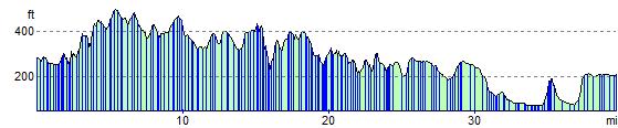
Elevation Profile