Quantocks Walks

Use the links to view full route information including elevation profiles, interactive maps and GPS downloads.
You can also view an overview map of all the routes in the using the Quantocks Walk Map>>
| Route Name | Photo | Distance | Description |
| Bridgwater Bay National Nature Reserve | 2 miles (2.5 km) | Explore this beautiful nature reserve on this short walk in the Somerset Levels. The reserve is situated on the mouth of the River Parrett with lovely views over the estuary to Stert Island and Burnham-on-Sea. It consists of extensive areas of mudflats, sand banks, reed beds and saltmarshes attracting a large number of birds. Look out for shelduck, curlew, redshank and oystercatcher from the excellent elevated bird hide. There is also an abundance of interesting flora with wildflowers and plants including Somerset hair grass,wild thyme, horseshoe vetch and birds-foot-trefoil. Steart Marshes nature reserve is also located on the south side of the peninsula with otters, egrets, owls waders and wildfowl to look out for. The River Parret Trail starts from Bridgwater Bay so you can pick this up to extend your walking in the area. The lovely waterside trail heads south to the nearby village of Combwich and then on to Bridgwater. This walk start from the Steart car park but you could also start from Combwich or Bridgwater and follow the River Parret Trail to the reserve. You could also head west along the estuary towards Hinckley Point Nuclear Power Station. It's a lovely walk with great views of the Sterte Flats and Catsford Common. View Full Details>> | |
| Coleridge Way | 51 miles (82 km) | Travel through the Exmoor National Park and the stunning Quantocks Hills as you walk in the footsteps of poet Samuel Taylor Coleridge. You start off in the pretty village of Nether Stowey, at the foot of the Quantock Hills and head west towards Holford, passing the iron age fort of Dowsborough on the way. You continue through a wooded section at Alfroxton Woods and onto Stowborrow Hill with its resident deer before passing through Bicknoller and Monksilver where you enter Combe Sydenham Country Park. Here you will find a 15th century stately home set in a 500 acres estate which includes a Deer Park and a variety of walks. The route continues through the Brendon Hills climbing to the high point of Lype Hill (1,388 ft) with wonderful views over the Exmoor National Park. You'll pass the villages of Luxborough and Cutcombe before climbing Horner Hill and passing the delightful Dunkery and Horner Woods Nature Reserve where you can enjoy a climb to Dunkery Beacon. The path then descends to the pretty coastal settlements of Porlock and Porlock Weir where there's a delightful harbour and beach. View Full Details>> | |
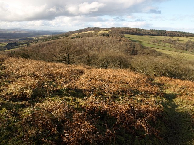
| Cothelstone Hill | 2 miles (3.5 km) | Enjoy heathland, woodland and wonderful views on this circular walk in the Quantocks. It's a lovely area with the groups of beech trees known as the Seven Sisters, bronze age burial mounds and the remains of a folly tower. You should also see several Exmoor Ponies around the hilltop and bluebells in the woodland in the spring. The walk starts at the car park just to the east of the hill, and follows good footpaths to the summit. Here you can enjoy wonderful 360 degree views across the Quantocks towards the Severn Estuary. It's a fabulous spot on a nice clear day. The walk then descends through woodland and past Merridge Hill before returning to the car park. The Samaritans Way South West and the Macmillan Way both cross the hill so you could pick these up to extend your walk. For example you could head north and visit Lydeard Hill and Wills Neck, the highest point in the Quantocks. View Full Details>> | |
| Crowcombe | 8 miles (12.3 km) | This Somerset based village makes a fine start point for exploring the surrounding Quantocks Hills and Brendon Hills. View Full Details>> | |
| Fyne Court | 2 miles (3 km) | Explore the gardens and 65 acre wider estate on this short walk in the Quantock Hills. In the estate you'll find three waymarked walking trails taking you to the most interesting areas on well surfaced paths. You'll visit the fine courtyard with a coach house, stable, library and music room. The trail then takes you into the beautiful gardens with a serpentine lake, boathouse, round-towered folly and a walled garden with ornamental trees and shrubs. There are also lovely woodland sections with beech trees and bluebells in spring. If you'd like to continue your walk then you could pick up the Samaritans Way South West and head up to the nearby Broomfield Hill and Cothelstone Hill where there are fabulous views over the Quantocks. This runs just to the north of the estate. View Full Details>> | |
| Great Wood Quantocks | 2 miles (3 km) | Enjoy miles of cycling and walking trails in this large area of woodland in the Quantocks. There is a red waymarked walking trail starting from the main car park which takes you to Ramscombe on good footpaths. The area has fine trees including ancient oaks, Majestic Douglas firs and Sitka spruce. There are also lovely streams and grassy glades to enjoy a picnic in. Look out for a variety of wildlife including red and roe deer, nightjar and sparrowhawk. The wood has miles of wide paths which are excellent for mountain biking. You can easily extend your ride by continuing along the many bridleways in Seven Wells Wood or Quantock Combe. To extend your walking in the area you could head east to Hawkridge Reservoir and enjoy circular walk around the water. On the south western fringe of the wood you will find Wills Neck, the highest point in the Quantock Hills. View Full Details>> | |
| Hawkridge Reservoir | 2 miles (2.5 km) | Enjoy a circular walk around this pretty reservoir in the Quantock Hills area of Somerset. There's nice footpaths climbing above the reservoir, with lovely views across the water to the surrounding countryside and woodland. You can start your walk from the roadside parking area on Lawyer's Hill. Then follow the road and public footpaths towards Ebsley Cottage at the eastern end of the water. The path then climbs towards Littledown with nice views back down to the reservoir. To extend your walking in the area, head west to the Great Wood where you will find miles of waymarked cycling and walking trails. On the south western fringe of Great Wood you will find Wills Neck, the highest point in the Quantock Hills. View Full Details>> | |
| Hestercombe House | 1 miles (2 km) | Explore the beautiful gardens surrounding this historic country house on the edge of the Quantock Hills. It's a nice place for an afternoon stroll with good footpaths taking you to peaceful woodland, beautiful lakes, a gothick alcove, a Tuscan temple arbour and a folly mausoleum. Hestercombe is generally considered to be one of the finest gardens in England. View Full Details>> | |
| Holford | 3 miles (5.5 km) | This lovely Quantocks village has some nice walks to try through the surrounding woodland and countryside. Just to the south of the village is a large area of woodland with a myriad of tracks and paths to try. The bridleways are also good for mountain bikers. You can pick up the trails from just south of the village. They will take you past Woodlands Hill towards Dowsborough Camp Iron Age Hill Fort. You then pass through Lady's Combe and Holford Combe before returning to the village. You can extend your exercise by visting the adjacent Great Wood or Hodder's Combe. The Coleridge Way also passes through the village and the woods. You can follow the trail from nearby Nether Stowey to visit the site. Similarly the long distance Quantock Greenway passes through Holford so this is another good option. View Full Details>> | |
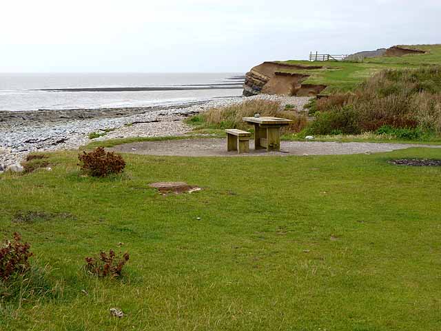
| Kilve Beach and East Quantoxhead | 3 miles (5.5 km) | This circular walk explores a beautiful area of coast and countryside in the Quantocks. View Full Details>> | |
| Lydeard Hill | 2 miles (2.5 km) | Climb to Lydeard Hill in the Quantocks an enjoy splendid views over the surrounding countryside on this short circular walk. You can start your walk from the Lydeard Hill car park on Lydeard Hill Road. It's a good sized parking area with great views, located just a mile east of the village of West Bagborough. From here you can pick up the footpaths to the hill summit which is a short distance from the car park. Head through the gate and then follow the wide paths to the hill top. You can then continue around the hill where there are nice woodland sections and open countryside to enjoy. You can extend your walk by picking up the Samaritans Way South West and following it to the nearby Wills Neck and Cothelstone Hill. View Full Details>> | |
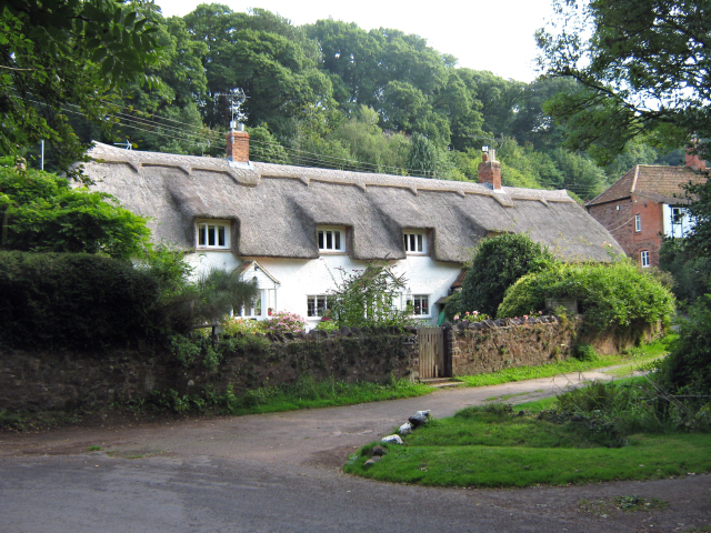
| Nether Stowey | 1 miles (1.6 km) | This picturesque Quantocks village has some nice country and woodland trails to the west and south of the settlement. The village itself is also a very pleasant place for a stroll with delightful cottages, a pretty stream and an old castle to visit. View Full Details>> | |
| North Petherton | 9 miles (14.6 km) | This Somerset based town sits in a nice position on the edge of the Quantocks. It's also close to some pleasant canalside and riverside walking trails. View Full Details>> | |
| Quantock Greenway | 36 miles (58 km) | A splendid figure of eight walk through the stunning Quantock Hils AONB. The walk begins at the pretty village of Broomfield which is the highest village on the Quantock Hills. The first section takes you to the tiny village of West Bagborough and then up a steep climb through Floorey Down and Great Wood. Another long woodland section then follows leading you to the village of Holford on the River Holford. View Full Details>> | |
| Watchet | 7 miles (11 km) | This coastal Somerset town is in a great spot for exploring the nearby Exmoor and Quantock Hills AONB. View Full Details>> | |
| West Bagborough | 9 miles (14 km) | This Quantocks village is in a superb location for starting a walk to the surrounding hills. There's also a very fine 16th century pub for post walk refreshment. View Full Details>> | |
| West Deane Way | 45 miles (72 km) | This wonderful circular walk takes you through the beautiful Somerset countryside including the Quantocks.
The path starts and ends in Taunton on the River Tone and heads north west towards West Bagborough. You continue through Lydeard St Lawrence and Wiveliscombe before a pleasant waterside stretch along the River Tone takes you back to Taunton via Bradford on Tone. In Taunton the trail links with the Bridgwater and Taunton Canal which offers more great opportunities for waterside walking or cycling. View Full Details>> | |
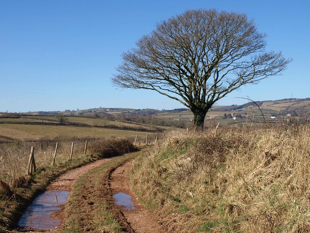
| Wills Neck | 2 miles (3.5 km) | Climb to the highest point in the Quantock Hills on this circular walk in Somerset. Wills Neck stands at a height of 1,261 ft (384 m) and commands wonderful views of Dartmoor, Exmoor, the Brecon Beacons, the Mendips and Blackdown Hills. This walk starts at the Triscombe Stone Car Park and follows the Macmillan Way to the Wills Neck summit. You descend on the Samaritans Way South West. It's a nice walk on decent footpaths with some attractive woodland and great views. The walk can easily be extended by visiting the nearby Bagborough Hill, Lydeard Hill and the interesting Triscombe Quarry. You could also head a couple of miles south and visit the lovely Cothelstone Hill where there are more great views and a herd of Exmoor Ponies. View Full Details>> |