Exmoor Walks

Use the links to view full route information including elevation profiles, interactive maps and GPS downloads.
You can also view an overview map of all the routes in the using the Exmoor Walk Map>>
| Route Name | Photo | Distance | Description |
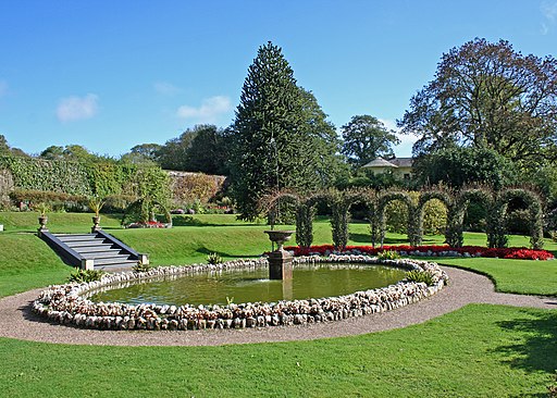
| Arlington Court | 2 miles (2.6 km) | This walk explores the grounds of the National Trust's Arlington Court on the edge of Exmoor in north Devon. View Full Details>> | |
| Bideford | 6 miles (10 km) | This attractive North Devon town has some lovely walks along the estuary of the River Torridge. There's also two significant waymarked trails which pass through the area, a lovely country park and a nature reserve to explore. This circular walk takes you along both sides of the river, using sections of the South West Coast Path and the Tarka Trail long distance trails. It requires a ferry trip from Instow to Appledore which is only available in the summer months. The walk starts on Bideford Long Bridge which connects the old part of the town with East-the-Water on the right bank of the Torridge. It is one of the longest mediaeval bridges in England, being 677 feet (222 yards) long with 24 arches. Cross the bridge to the eastern side and you will come to Chudleigh Fort. The fort was built in about 1642 during the English Civil War. It was then reconstructed in the 19th-century and has been a Grade II listed building since 1949. There is also a nice park with a war memorial here as well. On the eastern side of the water you pick up the Tarka Trail and follow it north to Torridge Bridge, Westleigh and Instow. Instow is a lovely little village with a pretty quay with views over to Appledore on the other side. There is a small river beach and sand dunes, that home some rare species of orchid including the pyramid orchid. From the quay you can pick up a summer ferry to take you over the river to Appledore. Here you can pick up the South West Coast Path and follow it south through Northam to return to Bideford. View Full Details>> | |
| Bossington Hill | 3 miles (4.5 km) | Enjoy fabulous views of the Exmoor coastline on this bracing climb near Porlock. The area also includes attractive flora including bell heather, ling heather and western gorse. Look out for wildlife including buzzards, peregrine falcons, kestrels. The walk starts from the car park at the end of Hill Road, just east of the village of Bossington. You then head north along public footpaths before picking up a section of the South West Coast Path to take you towards the hill summit. From here there are lovely views over the Bristol Channel to the Welsh coast. An alternative route is to follow the coast path from the village of Bossington to Hurlstone Point. Then turn south to reach the hill. You can easily extend the walk by exploring the Holnicote Estate and climbing to Selworthy Beacon. The beacon is located just to the east of Bossington Hill. Also nearby are the settlements of Porlock and Porlock Weir. Porlock Weir is particularly lovely, with 17th century cottages and a delightful harbour. View Full Details>> | |
| Brendon Hills | 5 miles (7.5 km) | Explore the Brendon Hills range on this challenging walk in the Exmoor National Park. The hills are a less well known area of the county so provide an opportunity for a quieter walk in idyllic surroundings. The attractive landscape consists of streams, rivers, rolling hills and wooded valleys. The walk starts from the village of Wheddon Cross near Cuttcombe. You then pick up the Coleridge Way and climb to Lype Hill, the highest point in the range at 1,388 feet (423 m). From here you can enjoy lovely views over the attractive Somerset and Exmoor countryside. The route then passes Lype Common and Colly Hill before descending to the village of Luxborough where you can enjoy refreshments. To continue your walking in the area you can climb the nearby Dunkery Beacon or pick up the Samaritans Way South West. There are also good woodland walking trails if you head north to Croydon Hill Iron Age hill fort from Churchtown. If you continue east along the Coleridge Way you will come to Combe Sydenham Country Park. View Full Details>> | |
| Challacombe | 2 miles (3.8 km) | This small Devon village sits on the edge of the Exmoor National Park. The peaceful area includes pleasant country trails, an old mill and a noteworthy pub dating back to the 1500s. View Full Details>> | |
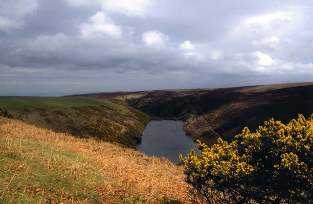
| Clatworthy Reservoir | 5 miles (8 km) | Enjoy a walk around this pretty reservoir in the Brendon Hills on the edge of the Exmoor National Park. There's lovely grassy footpaths running alongside the water with splendid views of the surrounding hills, countryside and woodland. You can park at the car park at the eastern side of the reservoir near to the dam. Then pick up the trails around the perimeter of the water. It's about a 5 mile (8km) walk around the whole reservoir or you can try a shorter nature trail through Clatworthy Wood. Here you'll find beech, oaks, silver birch and rowan trees and some pretty streams. Look out for red deer, roe deer and badgers in this area and geese, grebes and swans on the water. Just to the south of the reservoir you can pick up the West Deane Way long distance trail near Wiveliscombe. Here you can extend your walk by following the trail south along the River Tone towards Ashbrittle and Tracebridge. A few miles to the west you can enjoy more lakeside cycling and walking trails at the larger Wimbleball Lake. Just to the north you can pick up the Samaritans Way South West and explore the Brendon Hills and Combe Sydenham Country Park. View Full Details>> | |
| Coleridge Way | 51 miles (82 km) | Travel through the Exmoor National Park and the stunning Quantocks Hills as you walk in the footsteps of poet Samuel Taylor Coleridge. You start off in the pretty village of Nether Stowey, at the foot of the Quantock Hills and head west towards Holford, passing the iron age fort of Dowsborough on the way. You continue through a wooded section at Alfroxton Woods and onto Stowborrow Hill with its resident deer before passing through Bicknoller and Monksilver where you enter Combe Sydenham Country Park. Here you will find a 15th century stately home set in a 500 acres estate which includes a Deer Park and a variety of walks. The route continues through the Brendon Hills climbing to the high point of Lype Hill (1,388 ft) with wonderful views over the Exmoor National Park. You'll pass the villages of Luxborough and Cutcombe before climbing Horner Hill and passing the delightful Dunkery and Horner Woods Nature Reserve where you can enjoy a climb to Dunkery Beacon. The path then descends to the pretty coastal settlements of Porlock and Porlock Weir where there's a delightful harbour and beach. View Full Details>> | |
| Combe Martin | 7 miles (12 km) | This pretty coastal village is located on the north-west edge of the Exmoor National Park, close to some spectacular coastal scenery. Three significant long distance trails also pass the village so it is easy to explore the area on well maintained, waymarked footpaths. This loop takes you to some of the highlights to the east of the village including the highest point on the South West Coast Path. Starting in the village you pick up the Samaritans Way South West and head east past Lester Cliff and Wild Pear Beach to Little Hangman Cliff. The route climbs east to Great Hangman in the Hangman Hills. There's a cairn and fine views from the 1044 feet (318 metres) high summit here. The route continues past Girt Down to Holdstone Down where you can follow a circular footpath around Holdstone Hill. The route then returns to Combe Martin via Girt Down Farm, Netherton and Knap Down. View Full Details>> | |
| Combe Sydenham Country Park | 1 miles (1.5 km) | This country park consists of 500 acres of woodland, parkland and gardens surrounding a Grade I listed 15th century manor house. The house has an interesting history being previously owned by Elizabeth Sydenham who married Sir Francis Drake. It is alleged that Sir Francis Drake fired a cannonball into the grounds of the manor to warn Elizabeth not to marry another man. The expansive estate is a great place for walking with miles of waymarked trails to follow. There's lots to see with a deer park, herb garden, rose garden and peacock house. You can also stroll along a series of pretty pools with a lovely cascading stream, waterfalls and lots of wildlife to look out for. There is also a hill to climb with a viewpoint proffering great views over the of the Quantock hills and across the Seven Estuary to Wales. If you'd like to continue your walking in the area then you could head further into the Brendon Hills and climb to the high point of Lype Hill for more great views. The Coleridge Way also passes the park so you could pick up this long distance walk and head towards the Brendon Hills or the Quantocks. The little village of Monksilver is a good place to go for a bite to eat after your walk. View Full Details>> | |
| Culbone Church | 4 miles (7.2 km) | Visit England's smallest church on this lovely circular walk in the Exmoor National Park. The route includes coastal views, woodland sections and nice countryside views. The walk starts from the car park in Porlock Weir and heads west along the pretty quay to Worthy Wood. Here you pick up the Worthy Toll Road and follow it up to Yearner Mill Bridge where you turn north west towards the 17th century Parsonage Farm. You descend into the woodland of Withy Combe before coming to Culbone Church. The Grade I listed building is thought to be pre-Norman in origin, with a 13th-century porch, and late-15th-century nave. It seats around 30 people and services are still held there. The walk proceeds through Culbone Combe with pretty streams and attractive walnut and oak woodland. The final section runs through Yearnor Wood, passing the picturesque Worthy Toll Gate before returning to the car park. View Full Details>> | |
| Dulverton to Tarr Steps Walk | 19 miles (30 km) | Follow the River Barle from Dulverton to the famous medieval bridge at Tarr Steps. The walk takes you along a section of the Exe Valley Way long distance footpath with river views and woodland trails along the way. The walk starts in the small town of Dulverton, close to the border with Devon. It's a great base for exploring Exmoor and includes the Exmoor National Park Authority headquarters. Head west from the town centre to Bridge Street where you cross the river on the Barle Bridge. The ancient bridge has 5 stone arches and dates from the middle ages. Follow the riverside path north west, passing Burridge Wood and Northmoor Common before coming to Brewer's Castle Iron Age Hillfort. You continue through Hawkridge before branching off to the right and arriving Tarr Steps. The old clapper bridge is a Scheduled Ancient Monument, dating from the medieval period. View Full Details>> | |
| Dunkery Beacon | 5 miles (7.5 km) | This walk climbs to Dunkery Beacon on Dunkery Hill, the highest point in Exmoor and Somerset. From the 1,705 feet (520 m) summit there are fabulous views over Exmoor, the Brecon Beacons, Bodmin Moor, Dartmoor, the Severn Bridges and the Bristol and English Channels. The walk starts at the Dunkery Hill car park taking you up the hill to the beacon before heading into the delightful Dunkery and Horner Wood National Nature Reserve. The reserve covers 4000 acres/1604 hectares and is owned and managed by the National Trust. It consists of upland heath and woodland with a variety of wildlife including pied flycatcher, wood warbler, lesser spotted woodpecker, redstart and dipper. It also supports 14 of the 16 UK bat species, including barbastelle and Bechstein bats. You should also see several Exmoor Ponies and Exmoor's Iconic Red Deer. At the hill summit there's a handy toposcope where you can see all of the landmarks that are visible. If you would like to continue your walk you could head to the nearby Selworthy Beacon in the Holnicote Estate. Here you can enjoy more fabulous views of the Exmoor coast. The long distance Coleridge Way also passes close to the hill. You could pick this up and head north to the coast and visit Porlock and Porlock Weir. View Full Details>> | |
| Dunster Castle | 8 miles (13 km) | Explore the parkland, woodland and Historic Deer Park surrounding this Norman Castle near Minehead. From the castle there are fabulous views towards the Bristol channel, the Quantock hills and Exmoor. View Full Details>> | |
| Exe Valley Way | 52 miles (84 km) | The walk starts in Starcross on the banks of the River Exe Estuary and heads past the 14th century Powderham Castle and then along the Exeter Canal to Exeter. The next section continues along the River Exe to Tiverton via Thorverton and Bickleigh. The final section takes you from Tiverton into the Exmoor National Park where you will pass through Dulverton and Hawkridge before the finish at Exford in Somerset. This section passes close to the old clapper bridge at Tarr Steps near Dulverton and Withypool. It's well worth a short detour if you have time. Around here you'll also cross the picturesque five arched Landacre Bridge over the River Barle. The route finishes near Dawlish Warren where there is a lovely nature reserve with lots of waders to look out for. You can also pick up the Dawlish Sea Wall and enjoy a stroll along the train line, beach and red sandstone cliffs to nearby Dawlish. View Full Details>> | |
| Exford | 5 miles (8.2 km) | This walk takes you from Exford to nearby Winsford using a section of the Samaritans Way South West long distance trail. The trail runs along the River Exe with some nice countryside and woodland trails on the way. View Full Details>> | |
| Foreland Point | 5 miles (8 km) | This walk visits Foreland Point Lighthouse before exploring Countisbury Common on the Exmoor coast. View Full Details>> | |
| Haddon Hill | 4 miles (6.7 km) | This circular walk explores Haddon Hill in the Brompton Regis area of Somerset. The hill sits in a lovely spot on Exmoor close to the expansive Wimbleball Lake. View Full Details>> | |
| Heddon Valley | 2 miles (3.5 km) | Enjoy an easy waterside walk through the beautiful Heddon Valley in Exmoor. The riverside footpath leads through woodland before the beautiful coast and cliffs of Heddon's mouth come in to view. The walk starts at the National Trust car park and heads north through Heddon's Mouth Wood to the coast through Heddon's mouth with its imposing cliffs. The point where the valley opens out to reveal the sea and cliffs is really lovely. The path then leads down to the pebble beach where you will find a 19th century lime kiln. The area is great for wildlife spotting. Look out for otters and various birds suchs as dippers, grey wagtails and herons. In summer the area is covered with yellow gorse flowers and heather. If you would like to extend your walking in the area then you could head east towards Trentishoe Down for views of the beautiful Elwill Bay. You could also climb the Hangman Hills for tremendous views over Combe Martin. If you head east you will find the lovely wooded cove at Woody Bay with a secluded pebble beach. View Full Details>> | |
| Holnicote Estate | 3 miles (5 km) | This walk visits Selworthy Beacon and Bury castle in the splendid Holnicote Estate in Somerset. You start off in the village of Selworthy next to the church, and head to the nearby Bury Castle where you will find an Iron Age enclosure dating back to 400 B.C. You then climb to the 308 metres (1,010 ft) high Selworthy Beacon where there are marvellous views across Exmoor and the Somerset coast. It is one of the highest points in the Exmoor National Park along with Dunkery Beacon. From the high point you descend on Folly Combe, returning to the church soon after. If you would like to continue your walking in the area you could head to the nearby Dunkery Beacon. It is the highest point in Exmoor and consists of a beautiful nature reserve with woodland walks. You could also pick up the South West Coast Path and head west along this lovely stretch of coastline towards Bossington Hill and Porlock or east toward Minehead. View Full Details>> | |
| Ilfracombe to Combe Martin | 5 miles (8 km) | A popular coastal walk between these two North Devon settlements, using a section of the South West Coast Path. The route runs for a distance of about 5 miles so it's perfect for an afternoon walk. It's undulating path with some moderate climbs but with great views all the way from the elevated position of the cliff top path. The walk starts on the front in Ilfracombe and heads east past Capstone Point where there is a bench and a telescope to enjoy the view. You continue to Beacon Point which marks the northern side of Hillsborough Down and has nice views over Hele Bay. You continue past Samson's Bay and Widmouth Head before passing a series of caves on the outskirts of Combe Martin. The final section passes another fine viewpoint at Lester Point before coming into Combe Martin itself. View Full Details>> | |
| Ilfracombe to Woolacombe Coastal Walk | 8 miles (12.8 km) | The coast path between Ilfracombe and Woolacombe runs for about 8 miles along a series of dramatic cliffs, beautiful bays and lovely beaches. The walk starts on the front in Ilfracombe and climbs to Capstone Point and Capstone Hill. It's a fairly challenging start to the walk but with great views across the town and harbour as your reward. View Full Details>> | |
| Landacre Bridge from Withypool | 4 miles (7 km) | This circular walk takes you from the little village of Withypool to the medieval Landacre Bridge on Exmoor. It uses a section of the long distance Two Moors Way footpath to reach the picturesque scheduled ancient monument which spans the River Barle. Along the way there's lovely views across the National Park with lots of Exmoor Ponies to look out for too. The walk starts in the centre of the village where car parking is available. From here you can pick up a public footpath along the Two Moors Way, heading north west from the village. Follow the path for about a quarter of a mile to Kitridge Lane, where you turn left. The trail then follows the country lane for just over a mile until you reach Landacre Lane on the left. The lane will take you to the stone bridge with its distinctive five arches. It dates from the late medieval period and is Grade II listed. There's lovely views down the river to the moors in all both directions. Shortly after crossing the bridge, you can pick up a footpath on the left. This will take you through the countryside to Brightworthy where you can follow a nice riverside footpath along the Barle back into Withypool. To extend your walking in the Withypool area you can follow the river south along the Two Moors Way to Tarr Steps. Here you will find a medieval clapper bridge set in a beautiful riverside nature reserve. The Withypool to Tarr Steps Circular Walk uses a section of the Two Moors Way to visit the steps. The Exe Valley Way also passes through the village. You could follow it north to Exford and enjoy views of the River Exe. View Full Details>> | |
| Lorna Doone Walk | 5 miles (8.8 km) | Explore Exmoor's beautiful Doone Valley on this fine literary walk. View Full Details>> | |
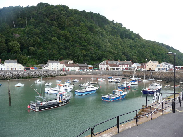
| Lynton and Lynmouth | 7 miles (11 km) | The town of Lynton and village of Lynmouth sit side by side on the Exmoor coast in north Devon. It's a splendid place for walkers with a number of long distance trails passing through the beautiful area. As well as the wonderful coastal views there's also nice woodland trails and riverside paths along the East Lyn River. This 7 mile circular walk visits some of the highlights of the area using waymarked trails on good paths. Starting in the centre of Lynton you first follow a section of the South West Coast Path east towards the picturesque harbour village of Lynmouth. The path descends to the village which sits at the confluence of the West Lyn and East Lyn rivers, in a gorge 700 feet (210 m) below Lynton. You continue towards Countisbury where you can climb to Foreland Point Lighthouse at the most northerly point along the Devon and Exmoor coast. From here there are great views across the Bristol Channel to the Welsh coast. The route then descends back to the hamlet of Countisbury before coming to Watersmeet. The delightful area includes 2000 acres of river gorge and woodland with the opportunity for refreshments at the riverside tea garden at Watersmeet House. The walk then follows a section of the Tarka Trail back to Lynton. There's lots of good options for continuing your walking in the area. One of the highlights is the climb to the Valley of the Rocks. This dry valley contains the geological marvels known as the Lynton Beds. You could follow the South West Coast Path east and visit Culbone Wood and the delightful village of Porlock Weir. You could also follow the Two Moors Way and Tarka Trail south to the Cheriton Ridge in the Exmoor National Park. The Samaritans Way South West also passes through the area. View Full Details>> | |
| Minehead | 6 miles (9.5 km) | Enjoy a coastal walk in this lovely Somerset town. The town includes a pretty harbour, quay and attractive beaches. This route takes you along the West Somerset Coast Path to one of the highlights of the area at Dunster Castle. The walk starts next to Minehead Train Station which is on the West Somerset Railway. You can catch the historic steam locomotives and enjoy views of the Quantocks on the scenic railway. From here you head south past the golf course to Dunster Beach. The beach is a splendid place for a walk with fine sea views and a nature reserve where you can look out for a variety of birdlife. After about a mile or so you can turn south and head past Dunster Station to Dunster Castle. The Norman Castle is surrounded by a lovely deer park where there are miles of footpaths to try. There's also some beautiful gardens and views toward the Bristol channel, the Quantock hills and Exmoor. After exploring the castle grounds the walk returns to the town centre on the same paths. View Full Details>> | |
| Minehead to Porlock Walk | 8 miles (13.5 km) | This walk follows a section of the South West Coast Path from Minehead to Porlock and Porlock Weir along the beautiful North Somerset coast. The walk runs for a distance of just over 8 miles with some moderate climbs to splendid viewpoints on the National Trust's Holnicote Estate. View Full Details>> | |
| Mortehoe Circular | 5 miles (7.5 km) | This circular walk from Mortehoe visits Morte Point, Rockham Bay and Bull Point on the North Devon Coast. It's a lovely section of Exmoor coast with dramatic cliffs, beautiful countryside and pretty beaches. The area is managed by the National Trust so there are good footpaths and facilities in the area. The walk starts from the village of Mortehoe where there is a village car park. You follow a footpath through the countryside to Morte Point where there are some fascinating rock formations and great views towards Lundy Island. You then head east along the coast path to Bull Point, passing the lovely Rockham Bay and beach on the way. You should see lots of pretty wildlflowers in the summer along this stretch. Just after Bull Point you pick up an inland footpath which takes you back to the village. Here you can enjoy refreshments at the Smuggler's Rest pub. You could also visit the Mortehoe Musuem and learn about the interesting history of smuggling and shipwrecks in the area. View Full Details>> | |
| Nutscale Reservoir | 1 miles (1.5 km) | This small reservoir is located on Exmoor near Minehead. The reservoir is in a lovely spot, surrounded by some attractive countryside and hills. There are footpaths and country lanes to follow south from the reservoir to Wilmersham Common. View Full Details>> | |
| Pinkery Pond | 3 miles (5.6 km) | This circular walk visits Pinkery Pond in the Barle Valley area of the Exmoor National Park. View Full Details>> | |
| Porlock and Porlock Weir | 6 miles (9 km) | This circular walk from the town of Porlock uses sections of the South West Coast Path and the Coleridge Way to take you on a tour of the coast and woods surrounding the town. The walk starts in Porock and follows the South West Coast Path east to Bossington before turning west along Porlock Bay to the pretty village of Porlock Weir. View Full Details>> | |
| Samaritans Way South West | 103 miles (166 km) | Starting at Bristol follow the Samaritans Way to Lynton, in Devon, and visit the Avon Gorge, the Chew Valley, the Cheddar Gorge, the Mendips, the Quantock Hills and the Brendon Hills. The walk also takes you through the beautiful Exmoor National Park where you will visit the lovely Doone Valley. Here you can try our lovely Lorna Doone Walk. View Full Details>> | |
| Selworthy | 6 miles (9 km) | This circular walk from the village of Selworthy climbs to Selworthy Beacon before visiting Bossington Hill, the lovely coastline at Hurlstone Point and the splendid pack horse bridge at the village of Allerford. View Full Details>> | |
| Simonsbath | 11 miles (17.5 km) | This small village sits in a remote spot high in the centre of Exmoor. View Full Details>> | |
| South Molton | 2 miles (4 km) | The market town of South Molton is located in a pleasant position in the Mole Valley. It is also close to Exmoor which is a fine place for walkers. View Full Details>> | |
| Tarka Trail | 79 miles (127 km) | This wonderful walk through Devon follows the path taken by Tarka the Otter in the book of that name. It is a circular walk starting and finishing in Barnstaple on the River Taw. After following the river for a short section you will head through Landkey Newton and East Buckland to the Exmoor National Park. The route then reaches Lynmouth where a splendid coastal section that takes you through Ilfracombe, Woolacombe and Croyde. The final section follows the estuary of the River Taw through Braunton and then back into Barnstaple. This part of the route passes the beautiful Braunton Burrows Nature Reserve. View Full Details>> | |
| Tarr Steps | 4 miles (6 km) | This circular walk visits the famous Tarr Steps before a lovely riverside stroll along the River Barle in the Exmoor National Park. It's a popular short walk with attractive woodland running alongside both sides of the fast flowing river. The old clapper bridge is a Scheduled Ancient Monument, dating from the medieval period. It forms part of the Tarr Steps Woodland National Nature Reserve which includes a wide range of interesting flora and fauna. For example, you can see plants including bluebell and honeysuckle in the spring and summer months. You can also look out for wildlife including red deer, dormice and otters as you make your way along the river. The walk starts from the car park just to the east of the bridge. From here it's a short walk to the bridge, which you can cross on foot. The route follows footpaths on both sides of the river, crossing a little footbridge at Great Bradley after about 2 miles. After your walk you can enjoy refreshments at the excellent Tarr Farm Inn, which has great views over the bridge. View Full Details>> | |
| The Hangman Hills | 5 miles (7.5 km) | A challenging circular walk visiting Little Hangman and Great Hangman Hills near Combe Martin in Devon. The walk starts in Combe Martin and heads east to Little Hangman Hill via Lester Point. You continue by climbing the 1044 feet (318 metres) high Great Hangman Hill. It is England's highest sea cliff and the highest point on the South West Coast Path. At the summit you wil find a cairn and can enjoy fabulous views over the surrounding coast and countryside. The route then descends through the countryside to Knap Down, before returning to Combe Martin. Here you can wander through the pretty village, admire the beautiful Combe Martin Bay and reward yourself with refreshments at one of the excellent pubs. There's also fine views over Holdstone Down and towards Lundy Island. In the summer months look out for pretty flowers such as primroses and violets and wildlife including warblers and various coastal birds. If you would like to extend your walking in the area then you could head east along the coast to the lovely Heddon Valley. Here you will find riverside walking trails and the imposing cliffs of Heddon's Mouth. View Full Details>> | |
| Two Moors Way | 90 miles (145 km) | Travel from Ivybridge to Lynmouth through the Dartmoor and Exmoor National Parks on this splendid walk through Devon and Somerset. The walk is generally not strenous taking you through tranquil moorland and the deep and wooded valleys of the moorland edges. The epic route runs for a distance of about 90 miles exposing you to some of the finest scenery in the south west of England. Highlights on the route include the splendid Avon Dam Reservoir and the fascinating old clapper bridge at Tarr Steps near Dulverton. Near Withypool you'll also cross the picturesque five arched Landacre Bridge over the River Barle. View Full Details>> | |
| Valley of the Rocks | 4 miles (6.2 km) | This walk visits the amazing Valley of the Rocks in the Exmoor National Park. The dry valley contains the geological marvels known as the Lynton Beds. These ancient rocks are a spectacular sight and hugely popular with walkers. View Full Details>> | |
| Watersmeet | 5 miles (8 km) | Follow a series of super trails through 2000 acres of river gorge and woodland on this lovely circular walk from Lynmouth to Watersmeet in Exmoor. View Full Details>> | |
| Wimbleball Lake | 7 miles (12 km) | Enjoy cycling and walking trails around this large lake on Exmoor. There is a super walking trail running around the perimeter of the lake. You'll enjoy long waterside sections, many peaceful woodland trails and views of the River Haddeo. This route is the round the lake walk but there are also a number of cycle trails with cycle hire available too. The three well surfaced trails are great for riders of all abilites. The easy green graded trail runs for just over a mile adjacent to the lake. It's perfect for families looking for a safe traffic free ride. It's easy to extend your walk and explore the surrounding countryside. You could enjoy a riverside walk along the River Haddeo near Hartford or you could climb Haddon Hill at the southern end of the lake, and enjoy splendid views across Exmoor. The park has excellent facilites with a cafe, cycle hire and parking available. Wimbleball Lake is located a few miles east of Dulverton where you can visit the popular Tarr Steps. To continue your walking in the area you could head a few miles east and visit Clatworthy Reservoir near Wiveliscombe. Here you will find a great 5 mile walking trail around the perimeter of the lake. Just to the north you can also pick up the Samaritans Way South West and explore the Brendon Hills and Combe Sydenham Country Park. View Full Details>> | |
| Wistlandpound Reservoir | 1 miles (2.4 km) | This pretty reservoir on the edge of Exmoor has a nice walking trail running around the perimeter. View Full Details>> | |
| Withypool to Tarr Steps Circular Walk | 6 miles (10.1 km) | This circular walk from Withypool uses a section of the Two Moors Way to visit the famous Tarr Steps. The first section includes woodland and riverside paths with the return leg taking place on more open country lanes. View Full Details>> | |
| Wiveliscombe | 4 miles (6.4 km) | This historic market town is located near Taunton in the county of Somerset. View Full Details>> | |
| Woody Bay | 2 miles (3 km) | Explore this peaceful wooded cove and enjoy waterfalls, woodland trails and splendid views of the Bristol Channel. Woody Bay is located on the coast of the Exmoor National Park. The Hanging Water stream runs through the woodland with lovely waterfalls and interesting flora and fauna to enjoy. This walk starts at the car park on Sir Robert's Path and takes you through the woodland to the pretty little bay with its secluded pebble beach. If you would like to extend your walking in the area then you could head west along the coast to the lovely Heddon Valley. View Full Details>> | |
| Woolacombe to Croyde | 6 miles (9.5 km) | A fine coastal walk between these two North Devon villages. You'll pass the sand dunes of Woolacombe Warren, the wonderful headland at Baggy Point and the lovely Croyde Bay. It's about a 6 mile walk with somer moderate climbs so a reaonable level of fitness is required. Starting in Woolacombe the path heads south along Woolacombe Sand and Morte Bay. On your left are the attractive hills of Woolacombe Down. You continue along the beautiful long stretch of beach to Putsborough before heading out to Baggy Point. Here you will find sandstone rocks popular with climbers and splendid views towards Lundy Island. The final section runs along the headland before finishing at Croyde Sands. View Full Details>> | |
| Woolacombe to Mortehoe | 4 miles (6.2 km) | This circular walk runs from Woolacombe to Mortehoe via Morte Point. The route runs for about 4 miles using a cliff top path with some moderate climbs. You start on the front in Woolacombe and heads north along the South West Coast Path to Morte Point. Here you will find a series of interesting rock formations and some lovely coastal views to Lundy Island. View Full Details>> |